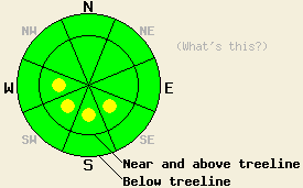
This Avalanche Advisory was published on December 23, 2009:

|
December 23, 2009 at 7:52 am |
|
Near and above treeline, pockets of MODERATE avalanche danger exist in wind loaded areas on SE-S-SW-W aspects, 35 degrees and steeper. Below treeline, avalanche danger is LOW. Deep slab instability is unlikely but not impossible below treeline at this time. |
|
|
|
Forecast Discussion:
Cold air is in place over the forecast area this morning. Combined with an air temperature inversion, temperatures are in the single digits at the valley floors and in the teens to low twenty's in most ridgetop locations. Skies have cleared overnight with plenty of sunshine expected across the region today. Moderate to strong NE winds have persisted for the past 24 hours and are expected to continue.
Observations made yesterday on Silver Peak (Pole Creek area) and on Mt. Judah (Donner Summit area) indicated that NE winds were scouring snow above treeline from NW-N-NE-E aspects and depositing it on SE-S-SW-W aspects (photo). Small, easily skier triggered slabs 5 to 10 inches deep were observed in both areas by mid day. On Mt. Judah, storm snow instability with small isolated natural avalanche activity on NE aspects near treeline (photo) occurred Sunday night and lasted through the early morning hours on Monday. This instability was observed to decrease as the day progressed. Recent observations from around the forecast area indicate that the persistent deep slab instability that has lurked below treeline on NW-N-NE aspects above 8,000' remains in some areas. It has become very difficult to trigger, but it remains.
Avalanche concern #1:
As NE ridgetop winds continue today, pockets of instability in the form of small unstable slabs will persist near and above treeline today. These slabs are expected in wind loaded areas on steep SE-S-SW-W aspects. Most of the slabs will be small today, but could be large enough to contribute to a human triggered avalanche large enough to bury or injure a person in isolated areas, especially if terrain traps are involved.
Avalanche Concern #2:
Persistent deep slab instability has become increasingly unlikely but is not impossible. Concern lingers for below treeline areas above 8,000' on NW-N-NE aspects. The October 19 facet layer (photo) is buried 2 to 4+ feet deep in the snowpack and has become very difficult to trigger. In some areas, this layer has gained enough strength that is no longer a concern. In other areas where this layer remains well developed (soft and sugary) and/or above 8,600' where it sits on top of the early Oct ice mass, the unlikely event of initiating a trigger through the stronger snow above could still cause a deep slab avalanche to occur.
The bottom line:
Near and above treeline, pockets of MODERATE avalanche danger exist in wind loaded areas on SE-S-SW-W aspects, 35 degrees and steeper. Below treeline, avalanche danger is LOW. Deep slab instability is unlikely but not impossible below treeline at this time.
Weather Observations from along the Sierra Crest between 8200 ft and 8800 ft:
| 0600 temperature: | 14 to 20 deg. F. |
| Max. temperature in the last 24 hours: | 18 to 25 deg. F. |
| Average wind direction during the last 24 hours: | Northeast |
| Average wind speed during the last 24 hours: | 45 mph |
| Maximum wind gust in the last 24 hours: | 89 mph |
| New snowfall in the last 24 hours: | 0 to trace inches |
| Total snow depth: | 35 to 56 inches |
Two-Day Mountain Weather Forecast - Produced in partnership with the Reno NWS
For 7000-8000 ft: |
|||
| Wednesday: | Wednesday Night: | Thursday: | |
| Weather: | Sunny skies. | Clear skies. | Sunny skies in the morning, becoming partly cloudy. |
| Temperatures: | 29 to 36 deg. F. | 12 to 18 deg. F. | 30 to 37 deg. F. |
| Wind direction: | NE | E | E |
| Wind speed: | 10 to 15 mph with gusts to 35 mph. | Up to 10 mph. | Around 10 mph. |
| Expected snowfall: | O in. | O in. | O in. |
For 8000-9000 ft: |
|||
| Wednesday: | Wednesday Night: | Thursday: | |
| Weather: | Sunny skies. | Clear skies. | Sunny skies in the morning, becoming partly cloudy. |
| Temperatures: | 32 to 38 deg. F. | 10 to 17 deg. F. | 29 to 36 deg. F. |
| Wind direction: | NE | E | N shifting to E |
| Wind speed: | 25 to 35 mph with gusts to 55 mph. Winds decreasing to 15 to 25 mph with gusts to 45 mph in the afternoon. | 10 to 20 mph with gusts to 40 mph. Gusts decreasing to 30 mph after midnight. | 10 to 15 mph with gusts to 25 mph. |
| Expected snowfall: | O in. | O in. | O in. |


