In partnership with: 
|
December 26, 2009 at 8:00 am |
|
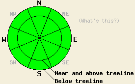
LOW avalanche danger exits at all elevations and on all aspects. LOW danger does not mean no danger. Isolated, deep-slab instability is unlikely but not impossible near and below treeline on NW-N-NE aspects above 8,000 ft. Use normal caution when travelling in the backcountry. |
|
|
|
The winds have shifted back to the southwest ahead of a low pressure system that should move into the forecast area tonight. This system should bring increased cloud cover, cooler temperatures, continued southwest winds and a chance for a little more snow tonight and tomorrow. The forecast calls for 2-5 inches of snow in the Sierra north of Lake Tahoe with lesser amounts farther south. Snow showers and winds should decrease tomorrow afternoon as this system moves out of the area.
We neither made nor received any new observations yesterday. However, observations from across the forecast area continue to show a layer of weak, sugary crystals near the bottom of the snowpack (the Oct. 19th facet layer- photo). Snowpit tests in the Deep Creek (video) area and on Carpenter Ridge (video) this week showed that this layer remains weak. In other areas including Incline Lake Peak, Cold Stream Canyon, Silver Peak, and Mt. Tallac, these tests showed a strengthening trend in this layer. All of the recent observations indicate that the strength and distribution of this layer remains variable. However, the strong well consolidated snow above the facets makes failure of this layer due to human-triggering unlikely.
Human-triggered avalanche activity remains unlikely today; however, it is not impossible. Isolated areas where the weight of a person could break the facets mentioned above may still exist on sheltered, NW-N-NE aspects above 8000 ft. In the unlikely event that avalanche activity does occur due to failure of this layer, the resulting avalanches will release without warning with crowns of 2-4 ft deep. These large avalanches would have dire consequences for those who triggered them. The uncertainty surrounding this layer's strength and distribution make stability evaluations on slopes with this layer unreliable and difficult. For these reasons continued caution in the backcountry is advised.
LOW avalanche danger exits at all elevations and on all aspects. LOW danger does not mean no danger. Isolated, deep-slab instability is unlikely but not impossible near and below treeline on NW-N-NE aspects above 8,000 ft. Use normal caution when travelling in the backcountry.
| 0600 temperature: | 26 deg. F. |
| Max. temperature in the last 24 hours: | 36 deg. F. |
| Average wind direction during the last 24 hours: | East shifting to the southwest after midnight |
| Average wind speed during the last 24 hours: | 15-25 mph |
| Maximum wind gust in the last 24 hours: | 52 mph |
| New snowfall in the last 24 hours: | O inches |
| Total snow depth: | 33-54 inches |
For 7000-8000 ft: |
|||
| Saturday: | Saturday Night: | Sunday: | |
| Weather: | Mostly cloudy | Cloudy with a chance of snow showers | Cloudy with a chance of snow showers in the morning. Snow should decrease in the afternoon. |
| Temperatures: | 27-37 deg. F. | 15-22 deg. F. | 24-31 deg. F. |
| Wind direction: | Southwest | Southwest | South |
| Wind speed: | 10 mph | 10-15 mph with gusts to 25 mph | up to 10 mph |
| Expected snowfall: | O in. | up to 2 in. | up to 2 in. |
For 8000-9000 ft: |
|||
| Saturday: | Saturday Night: | Sunday: | |
| Weather: | Mostly cloudy | Cloudy with a chance of snow showers | Cloudy with a chance of snow showers in the morning. Snow should decrease in the afternoon. |
| Temperatures: | 27-32 deg. F. | 14-19 deg. F. | 20-27 deg. F. |
| Wind direction: | Southwest | Southwest | South |
| Wind speed: | 10-15 mph with gusts to 25 mph | 10-15 mph with gusts to 30 mph | 10-15 mph with gusts to 25 mph |
| Expected snowfall: | O in. | up to 2 in. | up to 2 in. |


This website is owned and maintained by the non-profit arm of the Sierra Avalanche Center. Some of the content is updated by the USDA avalanche forecasters including the forecasts and some observational data. The USDA is not responsible for any advertising, fund-raising events/information, or sponsorship information, or other content not related to the forecasts and the data pertaining to the forecasts.

