In partnership with: 
|
December 29, 2009 at 7:47 am |
|
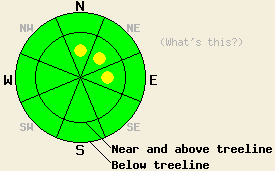
Near and above treeline, pockets of MODERATE avalanche danger exist in wind loaded areas on N-NE-E aspects, 35 degrees and steeper. Below treeline, avalanche danger is LOW. |
|
|
|
A series of small weather systems is moving through the forecast area. New snow of accumulation of 2 to 4 inches fell across most of the forecast area with remote sensors reporting up to 6 inches of new snow in the northern Carson range. Southwest ridgetop winds have decreased from moderate to light in speed this morning. Winds are expected to remain out of the southwest today and increase to strong in speed as the next weather system moves into the forecast area this afternoon. An additional 6 to 12 inches of new snow is expected tonight through Wednesday.
Observations made yesterday on Hidden Peak (West Shore Lake Tahoe area) indicated that recent new snow had bonded well to the old snow surface in near treeline areas along the summit ridgeline on steep N-NE aspects at 9,200'. Below treeline at 8,200' on a NE aspect 32 degree slope, snowpit data indicated that the Oct 19 basal layer had gained considerable strength in this location, contributing to a stable snowpack. Observations made Sunday in the Mount Rose and Donner Summit areas had pointed to short lived instability within the recent storm snow near and above treeline in heavily wind load areas. In below treeline areas, the Oct 19 basal layer is in variable states around the forecast area with excellent strength in some locations and lingering clicking here.
Avalanche concern #1:
Increasing winds this afternoon will cause continued wind transport of last night's new snow. Additional wind loading will occur today on N-NE-E aspects near and above treeline. Small slabs that exist this morning are expected to increase in size this afternoon. Small human triggered avalanches are possible today in heavily wind loaded areas.
Avalanche concern #2:
Deep slab instability involving the Oct 19 facet layer near the base of the snowpack is unlikely but not impossible below treeline on NE wind protected NW-N-NE aspects above 8,000'. Due to very strong snow in the middle and upper portions of the snowpack, failure of this layer is unlikely at this time.
Near and above treeline, pockets of MODERATE avalanche danger exist in wind loaded areas on N-NE-E aspects, 35 degrees and steeper. Below treeline, avalanche danger is LOW.
| 0600 temperature: | 18 to 20 deg. F. |
| Max. temperature in the last 24 hours: | 25 to 33 deg. F. |
| Average wind direction during the last 24 hours: | Southwest |
| Average wind speed during the last 24 hours: | 15 mph |
| Maximum wind gust in the last 24 hours: | 30 mph |
| New snowfall in the last 24 hours: | 2 to 6 inches |
| Total snow depth: | 36 to 58 inches |
For 7000-8000 ft: |
|||
| Tuesday: | Tuesday Night: | Wednesday: | |
| Weather: | Mostly cloudy skies with scattered snow showers in the afternoon. | Cloudy skies with a chance of snow in the evening. Snow after midnight. | Cloudy skies with snow. |
| Temperatures: | 24 to 29 deg. F. | 19 to 24 deg. F. | 24 to 29 deg. F. |
| Wind direction: | SW | SW | W |
| Wind speed: | 10 to 15 mph with gusts up to 30 mph in the afternoon. | 15 to 25 mph with gusts to 40 mph. | 20 to 30 mph with gusts 40 to 55 mph. |
| Expected snowfall: | Trace in. | 3 to 6 in. | 3 to 6 in. |
For 8000-9000 ft: |
|||
| Tuesday: | Tuesday Night: | Wednesday: | |
| Weather: | Mostly cloudy skies with scattered snow showers in the afternoon. | Cloudy skies with a chance of snow in the evening. Snow after midnight. | Cloudy skies with snow. |
| Temperatures: | 18 to 24 deg. F. | 13 to 18 deg. F. | 18 to 24 deg. F. |
| Wind direction: | SW | SW | SW shifting to W in the afternoon. |
| Wind speed: | 15 to 25 mph with gusts to 35 mph in the morning. 25 to 40 mph with gusts to 60 mph in the afternoon. | 30 to 50 mph with gusts 80 to 100 mph. | 25 to 40 mph with gusts 65 to 85 mph in the morning. 20 to 30 mph with gusts to 45 mph in the afternoon. |
| Expected snowfall: | Trace in. | 3 to 6 in. | 3 to 6 in. |


This website is owned and maintained by the non-profit arm of the Sierra Avalanche Center. Some of the content is updated by the USDA avalanche forecasters including the forecasts and some observational data. The USDA is not responsible for any advertising, fund-raising events/information, or sponsorship information, or other content not related to the forecasts and the data pertaining to the forecasts.

