This Avalanche Advisory was published on January 9, 2010:

|
January 9, 2010 at 8:00 am |
|
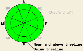
Avalanche danger is LOW for all elevations and aspects. Normal caution is advised. |
|
|
|
Forecast Discussion:
Another round of light precipitation fell across the forecast area yesterday afternoon. With snow levels hovering between 7500' and 8200', areas below 8000' received about .2 " of rain. Above 8200' 1-2" of heavy, wet snow fell along the Sierra Crest. East of Lake Tahoe only about .5 -1" of snow accumulated above 8200'. The small low pressure system that brought this precipitation moved out of the region last night allowing the skies to clear for a few hours. More clouds have started to move into the area this morning as another weak low pressure system approaches the forecast area. This system has even less water associated with it and should only bring a chance for isolated showers through tomorrow morning. A short-lived, high-pressure ridge should replace this low tomorrow bringing clearer skies and calmer winds.
Observations across the forecast area this week show a stable snowpack that continues to gain strength. Yesterday, observations on Angora Peak, Jakes Peak, and in the Mt. Rose backcountry showed that 1-3 inches of soft, melt/freeze snow existed on sun exposed SW-S-SE-E aspects by 11:00 am up to 9400'. Some roller-balls and wet-snow sluffs had occurred SE aspects around 8000' near Angora Peak over the last few days (photos). A mix of breakable and supportable crusts existed on the N-NE aspects on Jake's Peak above 8000'. In the Mt. Rose area some heavy unconsolidated snow remained on the N-NE aspects above 9300'. Below 9300' most aspects had a thin crust on the snow surface.
Avalanche concerns:
Avalanche activity will remain unlikely today. Clear skies last night should have allowed most of the snow surfaces to refreeze. Expect firm refrozen snow and frozen crusts on most aspects up to 9000' this morning. As the snow softens today due to daytime warming or more light rain, some small wet snow instabilities like sluffs and roller-balls could form. Less melting and warming should occur today due to slightly cooler temperatures, less sunshine, and less rain. These factors should prevent widespread wet snow instabilities from forming today. Slab avalanche activity remains unlikely.
Weather Observations from along the Sierra Crest between 8200 ft and 8800 ft:
| 0600 temperature: | 35 deg. F. |
| Max. temperature in the last 24 hours: | 39 deg. F. |
| Average wind direction during the last 24 hours: | Southwest |
| Average wind speed during the last 24 hours: | 25 mph |
| Maximum wind gust in the last 24 hours: | 53 mph |
| New snowfall in the last 24 hours: | Rain below 8000 ft. - .2 inches | Snow above 8000 ft. 1-2 inches |
| Total snow depth: | 37-61 inches |
Two-Day Mountain Weather Forecast - Produced in partnership with the Reno NWS
For 7000-8000 ft: |
|||
| Saturday: | Saturday Night: | Sunday: | |
| Weather: | Mostly cloudy with a slight chance for isolated snow showers this afternoon. Snow level between 7500 -8500 ft. | Mostly cloudy with a slight chance for isolated snow showers. | Mostly cloudy with a slight chance for isolated snow showers in the morning. |
| Temperatures: | 36-43 deg. F. | 22-29 deg. F. | 40-47 deg. F. |
| Wind direction: | Southwest | Southwest | Variable |
| Wind speed: | 10 mph | 10 mph | Light |
| Expected snowfall: | trace in. | trace in. | trace in. |
For 8000-9000 ft: |
|||
| Saturday: | Saturday Night: | Sunday: | |
| Weather: | Mostly cloudy with a slight chance for isolated snow showers this afternoon. Snow level between 7500 -8500 ft. | Mostly cloudy with a slight chance for isolated snow showers. | Mostly cloudy with a slight chance for isolated snow showers in the morning. |
| Temperatures: | 34-41 deg. F. | 22-29 deg. F. | 37-44 deg. F. |
| Wind direction: | Southwest | Southwest | South |
| Wind speed: | 10-15 mph | 10-15 mph | 10 mph |
| Expected snowfall: | trace in. | trace in. | trace in. |


