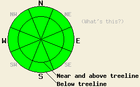
This Avalanche Advisory was published on January 11, 2010:

|
January 11, 2010 at 7:42 am |
|
Avalanche danger is LOW for all elevations and aspects. Normal caution is advised. |
|
|
|
Forecast Discussion:
A change in the weather will occur today as ridgetop winds and cloud cover increase ahead of a significant storm system expected to impact the forecast area late tonight. New snow accumulation of 1 to 2 feet is expected by Wednesday. Snow level is forecast to begin around 7,500' tonight and fall to 5,500' by Wednesday morning. Ridgetop winds shifted to the southwest overnight and are already beginning to increase this morning. An air temperature inversion remains in place with below freezing temperatures below 6,600'. Most remote sensors above 7,000' are reporting air temperatures in the mid to upper 30s.
Despite periods of above freezing air temperatures around the clock, light rain up to 8,500', and at times fog over the past week, a stable snowpack exists. Observations from around the forecast area over the past two weeks have seen significant rounding and strengthening of all portions of the snowpack in nearly all areas. Observations made yesterday on the lower portion of Jake's Peak (West Shore Tahoe area) indicated that the shallow snow pack below treeline at 7,200' on a NE aspect 40 degree slope still held good strength and stability, despite the presence of wet isothermal layers near the top and bottom (pit profile). Observations made yesterday in Horse Canyon outside the Bear Valley Ski Area below treeline at 8,080' on a N aspect 35 degree slope also indicated stable conditions (more info). When persistent crystal types such as facets exist, a few isolated areas of slower stabilization are expected. This was seen in observations made Saturday in Upper Ophir Creek (Mount Rose area) near treeline at 9,190' on a N aspect 28 degree slope where the October 19 facet layer persists in a well developed state (pit profile, photo, and videos). This has not been seen in other areas since mid to late December.
Avalanche concerns:
Snow surface conditions are in a melt freeze state on all aspects, especially below 9,100' throughout the forecast area. Above freezing air temperatures for the past 24 hours at the mid and upper elevations will have allowed for very little to no surface refreeze to have occurred last night. A few small wet snow sluffs may occur today in steep terrain, but wet slab avalanches remain unlikely. Avalanche activity occurring on the October 19 layer is highly unlikely at this time. With the persistence of faceted crystals in this layer in a few isolated areas, continued monitoring is needed to determine if future significant new loading from snow or rain may reawaken this deep slab instability.
Weather Observations from along the Sierra Crest between 8200 ft and 8800 ft:
| 0600 temperature: | 34-39 deg. F. |
| Max. temperature in the last 24 hours: | 44-48 deg. F. |
| Average wind direction during the last 24 hours: | South southwest |
| Average wind speed during the last 24 hours: | 22 mph |
| Maximum wind gust in the last 24 hours: | 36 mph |
| New snowfall in the last 24 hours: | O inches |
| Total snow depth: | 35-59 inches |
Two-Day Mountain Weather Forecast - Produced in partnership with the Reno NWS
For 7000-8000 ft: |
|||
| Monday: | Monday Night: | Tuesday: | |
| Weather: | Mostly cloudy | Cloudy with a slight chance for rain and snow. Snow level 7500 ft. | Snow |
| Temperatures: | 40-47 deg. F. | 32-38 deg. F. | 32-39 deg. F. |
| Wind direction: | Southwest | Southwest shifting to the south after midnight | Southwest |
| Wind speed: | 10 mph increasing to 10-15 mph with gusts to 25 mph in the afternoon | 10-15 mph increasing to 15-25 mph with gusts to 50 mph after midnight | 25-40 mph with gusts to 60 mph |
| Expected snowfall: | O in. | trace in. | 2-5 in. |
For 8000-9000 ft: |
|||
| Monday: | Monday Night: | Tuesday: | |
| Weather: | Mostly cloudy | Cloudy with a slight chance for snow. | Snow |
| Temperatures: | 41-47 deg. F. | 25-32 deg. F. | 28-35 deg. F. |
| Wind direction: | Southwest | Southwest | Southwest |
| Wind speed: | 20-30 mph with gusts to 40 mph increasing to gusts to 50 mph in the afternoon | 30-45 mph with gusts to 75 mph increasing to gusts to 95 mph after midnight | 40-60 mph gusts to 115 mph |
| Expected snowfall: | O in. | trace in. | 2-6 in. |


