In partnership with: 
|
January 12, 2010 at 8:00 am |
|
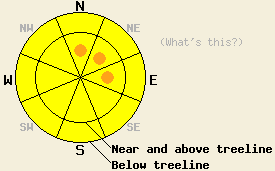
Near and above treeline, avalanche danger will rise to MODERATE around mid day with pockets of CONSIDERABLE danger possible by late day on N-NE-E aspects 35 degrees and steeper. Below treeline, avalanche danger will increase to MODERATE as the day progresses with periods of rain on new snow possible below 6,800'. |
|
|
|
Snow has returned to the forecast area this morning with a significant weather system expected to impact the area through mid day Wednesday. Snow level is right around 6,000' this morning and is expected to fluctuate between 6,000' and 6,500' during the day today, falling below 6,000' tonight. Ridgetop winds shifted from SW to SSW overnight and became strong with gusts over 110 mph. Ridgetop winds are expected to shift back to the SW and remain strong into Wednesday. New snow accumulations of 10 to 22 inches are expected over the next 30 hours in areas above 7,000'.
The past week has seen periods of above freezing air temperatures around the clock, light rain up to 8,500', and at times fog. Observations made in lower elevation areas yesterday on Donner Pass (Donner Summit area) at 7,179' in below treeline cliff area terrain on a NW aspect 32 degree slope (pit profile) and on Sunday on Jake's Peak (West Shore Tahoe area) at 7,200' in below treeline terrain on a NE aspect 40 degree slope (pit profile) both indicated a moist to wet, but still stable snowpack. Observations made Sunday in Horse Canyon outside the Bear Valley Ski Area below treeline at 8,080' on a N aspect 35 degree slope also indicated stable conditions (more info). Observations made Saturday in Upper Ophir Creek (Mount Rose area) near treeline at 9,190' on a N aspect 28 degree slope (pit profile, photo, and videos) and yesterday on Waterhouse Peak (Luther Pass area) below treeline at 9,250' on a N aspect 33 degree slope (pit profile, video) indicated that the October 19 facet layer was not fully rounded and retains faceted properties and could propagate fractures in some areas.
Avalanche concerns:
Avalanche concerns for today are focused on direct action events from new snow and rain. At all elevations, the existing snowpack is in good condition to handle new snow loading. New snow amounts over the next 30 hours are not expected to overburden the Oct 19 facet layer that exists near the base of the snowpack in isolated areas. New snow and strong SW winds will form slabs near and above treeline mainly in wind loaded areas on NW-N-NE-E-SE aspects as the day progresses. Snowpack failure is expected to occur near the old/new snow interface and possibly just below surface crusts where small near crust faceted crystals have been reported. In areas below 6,800', fluctuating snow levels may allow for periods of rain on new snow to occur today, creating small wet snow avalanches in steep terrain on all aspects.
Near and above treeline, avalanche danger will rise to MODERATE around mid day with pockets of CONSIDERABLE danger possible by late day on N-NE-E aspects 35 degrees and steeper. Below treeline, avalanche danger will increase to MODERATE as the day progresses with periods of rain on new snow possible below 6,800'.
| 0600 temperature: | 27 to 30 deg. F. |
| Max. temperature in the last 24 hours: | 40 to 46 deg. F. |
| Average wind direction during the last 24 hours: | South southwest |
| Average wind speed during the last 24 hours: | 40 mph |
| Maximum wind gust in the last 24 hours: | 111 mph |
| New snowfall in the last 24 hours: | trace to 2 inches |
| Total snow depth: | 35 to 62 inches |
For 7000-8000 ft: |
|||
| Tuesday: | Tuesday Night: | Wednesday: | |
| Weather: | Cloudy skies with snow. | Cloudy skies with snow. | Cloudy skies with snow in the morning, then snow showers in the afternoon. |
| Temperatures: | 33 to 40 deg. F. | 22 to 29 deg. F. | 25 to 32 deg. F. |
| Wind direction: | SW | S | S shifting to SW |
| Wind speed: | 20 to 30 mph with gusts to 55 mph. | 15 to 25 mph with gusts to 40 mph. | 15 to 25 mph with gusts to 40 mph. Winds decreasing to 10 to 15 mph with gusts to 25 mph in the afternoon. |
| Expected snowfall: | 3 to 7 in. | 3 to 7 in. | 4 to 6 in. |
For 8000-9000 ft: |
|||
| Tuesday: | Tuesday Night: | Wednesday: | |
| Weather: | Cloudy skies with snow. | Cloudy skies with snow. | Cloudy skies with snow in the morning, then snow showers in the afternoon. |
| Temperatures: | 28 to 35 deg. F. | 17 to 24 deg. F. | 24 to 30 deg. F. |
| Wind direction: | SW | SW | SW shifting to W |
| Wind speed: | 50 to 70 mph with gusts to 110 mph. | 35 to 55 mph with gusts to 110 mph. Gusts decreasing to 90 mph after midnight. | 30 to 45 mph with gusts to 70 mph. Winds decreasing to 25 to 35 with gusts to 60 mph in the afternoon. |
| Expected snowfall: | 4 to 7 in. | 4 to 8 in. | 4 to 7 in. |


This website is owned and maintained by the non-profit arm of the Sierra Avalanche Center. Some of the content is updated by the USDA avalanche forecasters including the forecasts and some observational data. The USDA is not responsible for any advertising, fund-raising events/information, or sponsorship information, or other content not related to the forecasts and the data pertaining to the forecasts.

