In partnership with: 
|
January 15, 2010 at 8:00 am |
|
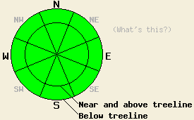
LOW avalanche danger exists on all elevations and aspects today. Avalanche activity will be unlikely but not impossible. Continue to use safe travel techniques and caution when traveling in the backcountry. |
|
|
|
The high-pressure ridge should keep mostly dry weather over the forecast area through Saturday. Daytime highs above 7000' should reach into the mid 40's today. By tomorrow the first in a series of low-pressure systems should move into the forecast area. The wind has already shifted back to the southwest, and some high clouds have moved into the area ahead of this storm. The forecast calls for this first system to weaken and split as it moves into the Central Sierra. Even though it should not produce much (if any) snow accumulation, it should push the high-pressure ridge out of the area and open the door for a series of stronger, wetter storms next week (video from the Reno NWS).
We received two more reports of avalanches that most likely occurred on Wed. The first occurred on a NE-facing, 35 degree slope in the Lost Lake area (near Blue Lakes out of Hope Valley) and may have been human-triggered (photos). The second one occurred on an E-facing, 40 degree slope near Stevens Peak (near Carson Pass) and looked to have been triggered by a natural cornice collapse (photos). Both slides occurred in near or above treeline terrain. We did not receive any reports of avalanche activity that occurred yesterday. Layer bonding tests on Mt. Tallac, Silver Peak, and Castle Peak all showed good bonding between the new snow layers and the old snow surfaces (photos, videos, and pit profiles). Observations in these areas did not reveal any other signs of instability and showed little to no east wind transport. A few skier-triggered sluffs did occur in all three of these areas on north-facing test slopes steeper than 35 degrees. Large, feathery surface hoar existed up to 8000' in these areas. Several inches of soft and unconsolidated snow remained on N-NE aspects in all three of these areas. Below 7500' where less snow fell during the storm "dust on crust" surface conditions existed. Overall observations point to mostly stable snowpack.
Avalanche concerns:
Settlement and stronger bonding in the new snow layers and along the old/new snow interface have decreased the risk of avalanche activity. With mild temperatures, light winds, and little to no new snow forecasted for the next 36 hours, the snowpack should continue to gain strength. Remember LOW danger does not mean no danger. Even though avalanche activity will be unlikely today, avalanches are not impossible. Continue to use safe travel techniques and caution when traveling in the backcountry.
LOW avalanche danger exists on all elevations and aspects today. Avalanche activity will be unlikely but not impossible. Continue to use safe travel techniques and caution when traveling in the backcountry.
| 0600 temperature: | 31-39 deg. F. |
| Max. temperature in the last 24 hours: | 31-41 deg. F. |
| Average wind direction during the last 24 hours: | East until midnight then shifting to the southwest |
| Average wind speed during the last 24 hours: | East: 25-30 mph | Southwest: 15 mph |
| Maximum wind gust in the last 24 hours: | East: 48 mph | Southwest: 27 mph |
| New snowfall in the last 24 hours: | O inches |
| Total snow depth: | 47-70 inches |
For 7000-8000 ft: |
|||
| Friday: | Friday Night: | Saturday: | |
| Weather: | Mostly cloudy | Mostly cloudy | Mostly cloudy with a slight chance of snow showers in the afternoon. |
| Temperatures: | 37-44 deg. F. | 18-25 deg. F. | 32-42 deg. F. |
| Wind direction: | Southwest | South | South |
| Wind speed: | 10-15 mph with gusts to 30 mph | 10-15 mph with gusts to 30 mph increasing to 40 mph after midnight | 15-25 mph with gusts to 45 mph |
| Expected snowfall: | O in. | O in. | trace in. |
For 8000-9000 ft: |
|||
| Friday: | Friday Night: | Saturday: | |
| Weather: | Mostly cloudy | Mostly cloudy | Mostly cloudy with a slight chance of snow showers in the afternoon. |
| Temperatures: | 39-45 deg. F. | 21-28 deg. F. | 32-38 deg. F. |
| Wind direction: | Southwest | Southwest | South |
| Wind speed: | 10-15 mph with gusts to 35 mph increasing to 15-25 mph with gusts to 50 mph this afternoon | 20-30 mph with gusts to 60 mph | 20-30 mph with gusts to 55 mph decreasing to 45 mph this afternoon |
| Expected snowfall: | O in. | O in. | trace in. |


This website is owned and maintained by the non-profit arm of the Sierra Avalanche Center. Some of the content is updated by the USDA avalanche forecasters including the forecasts and some observational data. The USDA is not responsible for any advertising, fund-raising events/information, or sponsorship information, or other content not related to the forecasts and the data pertaining to the forecasts.

