In partnership with: 
|
January 20, 2010 at 7:59 am |
|
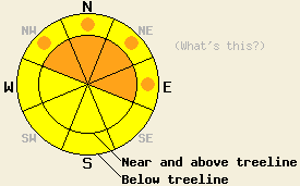
Near and above treeline the avalanche danger is CONSIDERABLE on NW-N-NE-E aspects steeper than 35 degrees. Below treeline pockets of CONSIDERABLE danger exist on open, NW-N-NE-E aspects steeper than 35 degrees. The avalanche danger is MODERATE on all other aspects. As more snow falls today, avalanches will become easier to trigger and more widespread. |
|
|
|
Another 4-7 inches of 14-17% density snow fell across the forecast area over the last 24 hours. This new snow brings the snowfall totals since Sunday to 22-30 inches for most of the central Sierra. Strong southwest winds buffeted the area over the last 24 hours. Along the Sierra crest these winds have averaged 45-55 mph with maximum gusts of over 120 mph. These winds should remain strong through tonight due to another stronger low-pressure-system moving into the region. The forecast calls for this storm to bring another 1-2 feet of snow to the mountains above 7000' in the next 24 hours. By tomorrow snow showers should start to taper off, and the winds should shift to the south and decrease as the storm moves off to the south and east. Click here for a short video summary of the upcoming weather from the Reno NWS.
Yesterday, observations from Jake's Peak (West Shore) and the Frog Lake area (Carson Pass) indicated that several weakness remain in the storm snow. Even though the break in the storm yesterday did allow these weaknesses to gain some strength, layer bonding tests (pit profile and photo) in these areas showed that these weaknesses remain fragile. In the Frog Lake area, skiers triggered small wind slabs on several small, N-facing, wind-loaded test slopes near treeline (details and photos). Skiers also triggered a small avalanche on a steep, wind-loaded slope 50ft away from their ski tracks. Skier-triggered shooting cracks occurred in wind-loaded terrain in the Frog Lake area and on Jake's Peak. Wind-affected snow existed on the snow surface in both these areas. The strong south and southwest winds continued to transport snow from windward aspects to leeward aspects throughout the day (video). Layer bonding tests on Jake's Peak showed that the deeper weak layers have continued to gain strength in that area.
Avalanche Concern #1:
That's right more wind and 1-2 feet of snow means larger, heavier, more widespread wind slabs. These wind slabs will remain the primary avalanche concern today. Human-triggered avalanches involving these wind slabs will be probable today. As the forecast area receives more snow over the next 24 hours, wind slabs will become easier to trigger and natural avalanches will be possible. In heavily wind-loaded areas these wind slabs could easily be several feet deep and entrain, literally, tons of snow. These wind slabs will most likely exist on wind-loaded, NW-N-NE-E aspects near and above treeline. Some pockets of wind slabs could also exist in heavily wind-loaded areas below treeline.
Avalanche Concern #2:
New weakness will form within the new snow that falls today. The added weight of a person could break these weakness causing avalanches to release. Since some weaknesses still exist in the snow that has fallen since Sunday, any slides that do release could step down to these lower weaknesses. Avalanche activity due to these storm snow weaknesses will be possible today on any open slopes steeper than 35 degrees especially later in the day as more snow accumulates.
Avalanche Concern #3:
Even though observations this week indicate that the older weak layers continue to gain strength and that deep slab avalanches are unlikely, they are not impossible in very isolated areas. As more snow accumulates these deeper avalanches become less impossible. With enough added weight the small layer of weak, sugary crystals that exists near the Jan. 11th crust in some areas could break. If this layer does break the resulting avalanches would be large and destructive.
Near and above treeline the avalanche danger is CONSIDERABLE on NW-N-NE-E aspects steeper than 35 degrees. Below treeline pockets of CONSIDERABLE danger exist on open, NW-N-NE-E aspects steeper than 35 degrees. The avalanche danger is MODERATE on all other aspects. As more snow falls today, avalanches will become easier to trigger and more widespread.
| 0600 temperature: | 20 deg. F. |
| Max. temperature in the last 24 hours: | 23 deg. F. |
| Average wind direction during the last 24 hours: | Southwest |
| Average wind speed during the last 24 hours: | 45-55 mph |
| Maximum wind gust in the last 24 hours: | 123 mph |
| New snowfall in the last 24 hours: | 4-7 inches |
| Total snow depth: | 67-94 inches |
For 7000-8000 ft: |
|||
| Wednesday: | Wednesday Night: | Thursday: | |
| Weather: | Snow with isolated, scattered thunderstorms possible this afternoon. | Snow with isolated, scattered thunderstorms possible this evening. | Snow |
| Temperatures: | 20-27 deg. F. | 12-19 deg. F. | 22-29 deg. F. |
| Wind direction: | Southwest | South | South |
| Wind speed: | 20-30 mph with gusts to 35 mph increasing to 50 mph this afternoon | 20-30 mph with gusts to 50 mph | 15-25 mph with gusts to 45 mph |
| Expected snowfall: | 8-12 in. | 6-12 in. | 4-7 in. |
For 8000-9000 ft: |
|||
| Wednesday: | Wednesday Night: | Thursday: | |
| Weather: | Snow with isolated, scattered thunderstorms possible this afternoon. | Snow with isolated, scattered thunderstorms possible this evening. | Snow |
| Temperatures: | 17-24 deg. F. | 9-16 deg. F. | 18-25 deg. F. |
| Wind direction: | Southwest | Southwest shifting to the south after midnight | South |
| Wind speed: | 30-45 mph with gusts to 80 mph increasing to 40-55 mph with gusts to 90 mph | 40-55 mph with gusts to 90 mph decreasing to 25-40 mph with gusts to 75 mph after midnight | 20-35 mph with gusts to 65 mph decreasing to 50 mph in the afternoon |
| Expected snowfall: | 10-15 in. | 8-14 in. | 5-8 in. |


This website is owned and maintained by the non-profit arm of the Sierra Avalanche Center. Some of the content is updated by the USDA avalanche forecasters including the forecasts and some observational data. The USDA is not responsible for any advertising, fund-raising events/information, or sponsorship information, or other content not related to the forecasts and the data pertaining to the forecasts.

