In partnership with: 
|
January 23, 2010 at 7:51 am |
|
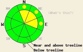
Near and above treeline, avalanche danger is MODERATE on wind loaded N-NE-E aspects, 35 degrees and steeper. Below treeline, avalanche danger is LOW with pockets of MODERATE danger in recently wind loaded areas, 37 degrees and steeper. |
|
|
|
Mostly cloudy skies and scattered snow showers are expected for today as a weather system passes to the north of the forecast area. New snowfall from the past 24 hours measures a trace to 4 inches. Storm totals from the past week measure 4 to 6+ feet by location. Light to moderate westerly to northwesterly ridgetop winds this morning are forecast to decrease this afternoon. Remote sensors are reporting air temperatures above 8,000' in the low to mid teens this morning.
Observations made yesterday on Carpenter Ridge (Independence Lake area) near treeline at 8,600' on a N aspect 34 degree slope revealed unstable slabs just over 1 foot thick in wind loaded areas. Easily skier triggered test slope failure and very easy fracture propagation test scores exposed the storm snow weakness at the base of the snow that fell Thursday night (pit profile, photos, video). The recent storm snow below the unstable surface slab continues to gain strength, keeping observed instability in the top 1 to 2 feet of the snowpack. No evidence of instability was observe in non wind loaded areas.
Avalanche Concerns:
Avalanche concerns for today remain focused on recently wind loaded areas. The greatest areas of instability will be found near and above treeline on N-NE-E aspects. Below treeline, pockets of instability may be found in areas that show evidence of recent wind loading. The storm snow has had some time to settle and stabilize since yesterday. This will make avalanches harder to trigger today than yesterday. That said, human triggered avalanches involving slabs 1 to 2+ feet deep remain possible today and backcountry travelers should continue to exercise caution.
Near and above treeline, avalanche danger is MODERATE on wind loaded N-NE-E aspects, 35 degrees and steeper. Below treeline, avalanche danger is LOW with pockets of MODERATE danger in recently wind loaded areas, 37 degrees and steeper.
| 0600 temperature: | 13 to 15 deg. F. |
| Max. temperature in the last 24 hours: | 20 to 25 deg. F. |
| Average wind direction during the last 24 hours: | Southwest |
| Average wind speed during the last 24 hours: | 25 mph |
| Maximum wind gust in the last 24 hours: | 61 mph |
| New snowfall in the last 24 hours: | trace to 4 inches |
| Total snow depth: | 80 to 110 inches |
For 7000-8000 ft: |
|||
| Saturday: | Saturday Night: | Sunday: | |
| Weather: | Mostly cloudy skies with scattered snow showers. | Mostly cloudy skies. | Mostly cloudy skies with a slight chance of snow in the morning. Snow likely in the afternoon. |
| Temperatures: | 19 to 26 deg. F. | 9 to 16 deg. F. | 26 to 33 deg. F. |
| Wind direction: | NW | S | SW |
| Wind speed: | Around 10 mph in the morning becoming light. | Light winds becoming around 10 mph after midnight. | Around 10 mph. |
| Expected snowfall: | 0 to trace in. | O in. | 1 to 4 in. |
For 8000-9000 ft: |
|||
| Saturday: | Saturday Night: | Sunday: | |
| Weather: | Mostly cloudy skies with isolated snow showers. | Mostly cloudy skies. | Mostly cloudy skies with a slight chance of snow in the morning. Snow likely in the afternoon. |
| Temperatures: | 18 to 24 deg. F. | 10 to 16 deg. F. | 24 to 31 deg. F. |
| Wind direction: | NW | S | SW |
| Wind speed: | 10 to 20 mph with gusts to 35 mph in the morning. | Light winds becoming around 10 mph after midnight. | 10 to 15 mph with gusts to 35 mph. |
| Expected snowfall: | 0 to trace in. | O in. | 1 to 4 in. |


This website is owned and maintained by the non-profit arm of the Sierra Avalanche Center. Some of the content is updated by the USDA avalanche forecasters including the forecasts and some observational data. The USDA is not responsible for any advertising, fund-raising events/information, or sponsorship information, or other content not related to the forecasts and the data pertaining to the forecasts.

