In partnership with: 
|
January 25, 2010 at 8:00 am |
|
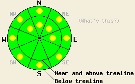
Near and above treeline, pockets of MODERATE avalanche danger exist on wind loaded NW-N-NE-E aspects 35 degrees and steeper. Pockets of MODERATE avalanche danger will also form on slopes that receive rain below 7000' today. Avalanche danger should increase and become more widespread as more snow accumulates. |
|
|
|
Another low-pressure system should move into northern CA today. This system should bring some snow to the forecast area; however, most of the precipitation should fall north of here. The forecast calls for an additional 4-10 inches of snow in the next 24 hours. The winds should remain out of the southwest and increase tonight before they start to decrease again tomorrow as this system moves away. This system should push a wave of warmer air ahead of it causing snow levels to climb to between 6500 and 7000 feet today. Remote sensors already report temperatures in the low 30's up to 7500 feet this morning. The snow level should fall back down to lake level this evening.
Yesterday most layer-bonding tests and observations on Mt. Judah (Donner Summit area), on Tamarack Peak (Mt. Rose area), on Scout Peak (Echo Summit area), and on Poison Peak (Bear Valley area) showed a stable snowpack. One test slope did fail on the far east ridge of Tamarack Peak (video and photo). A small 8 in to 1ft deep avalanche released on this 38 degree, N-facing, wind loaded, near-treeline slope when a skier stepped onto the top of the slope. Other similar test-slopes in the Mt. Rose area and in the other parts of the forecast area mentioned above did not release or even crack in response to a person's weight. The southwest winds continued to transport snow from windward slopes to leeward slopes near and above treeline yesterday. In most areas cold, soft, unconsolidated snow exists on the snow surface.
Avalanche Concern #1:
Continued instability due to fragile wind slabs on wind-loaded slopes will comprise the primary avalanche concern today. The light accumulation and continued southwest winds have caused these slabs to grow some over the last 24 hours. This morning pockets of human-triggerable wind slabs should exist on the most heavily wind-loaded NW-N-NE-E aspects near and above treeline. As more snow and wind impact the forecast area this afternoon and evening, these slabs should grow larger, more widespread, and more sensitive. Any slides that occur should be limited to the upper 1-2 ft of the snowpack.
Avalanche Concern #2:
Rain on snow could cause some avalanche activity below 7000' today. The rain will quickly warm up the recent snow and melt bonds that have formed within making the snow weaker and more unstable. Most instabilities that form due to this weakening should manifest as roller-balls and point-release avalanches today. However isolated small, slab avalanches on slopes steeper than 35 degrees that receive rain could be possible today.
Near and above treeline, pockets of MODERATE avalanche danger exist on wind loaded NW-N-NE-E aspects 35 degrees and steeper. Pockets of MODERATE avalanche danger will also form on slopes that receive rain below 7000' today. Avalanche danger should increase and become more widespread as more snow accumulates.
| 0600 temperature: | 29 deg. F. |
| Max. temperature in the last 24 hours: | 29 deg. F. |
| Average wind direction during the last 24 hours: | Southwest |
| Average wind speed during the last 24 hours: | 36 mph |
| Maximum wind gust in the last 24 hours: | 53 mph |
| New snowfall in the last 24 hours: | 2-5 inches |
| Total snow depth: | 82-112 inches |
For 7000-8000 ft: |
|||
| Monday: | Monday Night: | Tuesday: | |
| Weather: | Chance of snow showers this morning with snow increasing this afternoon. Snow level between 6500 and 7000 ft. | Snow | Snow showers in the morning decreasing in the afternoon. |
| Temperatures: | 27-34 deg. F. | 22-29 deg. F. | 26-33 deg. F. |
| Wind direction: | Southwest | Southwest | Southwest |
| Wind speed: | 10-15 mph with gusts to 25 mph | 15-20 mph with gusts to 40 mph | 10-20 mph with gusts to 40 mph |
| Expected snowfall: | 2-4 in. | 2-5 in. | up to 1 in. |
For 8000-9000 ft: |
|||
| Monday: | Monday Night: | Tuesday: | |
| Weather: | Chance of snow showers this morning with snow increasing this afternoon. | Snow | Snow showers in the morning decreasing in the afternoon. |
| Temperatures: | 23-30 deg. F. | 20-27 deg. F. | 21-28 deg. F. |
| Wind direction: | Southwest | Southwest | Southwest |
| Wind speed: | 15-25 mph with gusts to 55 mph | 25-40 mph with gusts to 75 mph | 20-30 mph with gusts to 60 mph decreasing to 40 mph in the afternoon |
| Expected snowfall: | 2-4 in. | 3-6 in. | up to 2 in. |


This website is owned and maintained by the non-profit arm of the Sierra Avalanche Center. Some of the content is updated by the USDA avalanche forecasters including the forecasts and some observational data. The USDA is not responsible for any advertising, fund-raising events/information, or sponsorship information, or other content not related to the forecasts and the data pertaining to the forecasts.

