This Avalanche Advisory was published on January 26, 2010:

|
January 26, 2010 at 8:00 am |
|
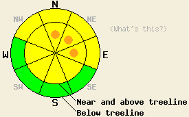
Near and above treeline, pockets of CONSIDERABLE avalanche danger exist on wind-loaded N-NE-E aspects 35 degrees and steeper. Below treeline the avalanche danger is MODERATE on open NW-N-NE-E aspects steeper than 37 degrees. |
|
|
|
Forecast Discussion:
Over the last 24 hours, 7-10 inches of wet, heavy, 17-22%-density snow has fallen across the forecast area. Some snow showers could continue today as the low-pressure system moves out of the area. However these showers should not produce much additional accumulation. The southwest winds should start to decrease this afternoon. By tonight a high-pressure ridge building over the region should cause the winds to shift to the north and east. This high-pressure should also bring clearer skies and an end to the snow showers by tomorrow.
The heavy, new snow layer sits on top of lighter, less dense snow across the forecast area (photo). Skier-triggered shooting cracks started to occur on Castle Peak yesterday afternoon on wind-loaded test slopes. One small (4-6 inch crown, 8 ft wide, and 10ft long) avalanche released on a N-facing, wind-loaded, 38 degree, test slope (photos). The small, newly-formed cornices above these slopes were sensitive to a person's weight. Hand pits and layer bonding tests on Castle Peak and on Porcupine Ridge (south of Heavenly Ski Area) revealed that the bonds between the heavy, new snow and lighter snow below it would break with easy to moderate force. This morning Alpine Ski Patrol reported weaknesses within the new snow that broke in response to light force.
Avalanche Concern #1:
Heavy wind slabs have formed on top of lighter, weaker snow over the last 24 hours. As the southwest winds continue today, these wind slabs will continue to grow. Human-triggering of these wind slabs will be possible today. The best window for natural avalanche activity involving these wind-slabs should have occurred last night and early this morning. However, the possiblity of natural avalanches due to failure of these wind slabs will linger on the most heavily wind-loaded slopes near and above treeline today. Sensitive wind slabs will most likely exist on wind-loaded, N-NE-E aspects steeper than 35 degrees near and above treeline. Large, heavy, and tender cornices will likely lurk above many of these slopes. Use clues like cornices, blowing snow, drifts, ripples, and other wind-created textures to help determine which slopes are wind-loaded.
Avalanche Concern #2:
The heavy, wet snow that sits on top of colder, lighter, weaker snow has created and upside-down snowpack in most of the forecast area. The additional weight of a person could overload the lighter snow and cause it release its hold on the heavy snow above it, resulting in avalanches involving the new snow. Open NW-N-NE-E aspects steeper than 37 degrees above and below treeline will hold best possibilities for these kinds of avalanches. Some loose, point-release activity and roller-balls involving the warm, heavy, wet snow may also continue today.
The bottom line:
Near and above treeline, pockets of CONSIDERABLE avalanche danger exist on wind-loaded N-NE-E aspects 35 degrees and steeper. Below treeline the avalanche danger is MODERATE on open NW-N-NE-E aspects steeper than 37 degrees.
Weather Observations from along the Sierra Crest between 8200 ft and 8800 ft:
| 0600 temperature: | 27 deg. F. |
| Max. temperature in the last 24 hours: | 32 deg. F. |
| Average wind direction during the last 24 hours: | Southwest |
| Average wind speed during the last 24 hours: | 39 mph |
| Maximum wind gust in the last 24 hours: | 90 mph |
| New snowfall in the last 24 hours: | 7 inches |
| Total snow depth: | 89-112 inches |
Two-Day Mountain Weather Forecast - Produced in partnership with the Reno NWS
For 7000-8000 ft: |
|||
| Tuesday: | Tuesday Night: | Wednesday: | |
| Weather: | Cloudy with isolated snow showers. | Cloudy with scattered snow showers becoming partly cloudy after midnight. | Partly cloudy |
| Temperatures: | 27-34 deg. F. | 14-21 deg. F. | 25-32 deg. F. |
| Wind direction: | Southwest | Northeast | East |
| Wind speed: | 10-20 mph with gusts to 35 mph | 10 mph | 10 mph |
| Expected snowfall: | less than 1 in. | less than .5 in. | O in. |
For 8000-9000 ft: |
|||
| Tuesday: | Tuesday Night: | Wednesday: | |
| Weather: | Cloudy with isolated snow showers. | Cloudy with scattered snow showers becoming partly cloudy after midnight. | Partly cloudy |
| Temperatures: | 26-32 deg. F. | 13-20 deg. F. | 22-29 deg. F. |
| Wind direction: | Southwest | West shifting to the northeast after midnight | Northeast |
| Wind speed: | 20-30 mph with gusts to 55 mph decreasing to 40 mph in the afternoon | 15-20 mph with gusts to 35 mph | 10-15 mph with gusts to 25 mph |
| Expected snowfall: | less than 1 in. | less than .5 in. | O in. |


