In partnership with: 
|
February 2, 2010 at 8:00 am |
|
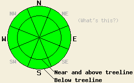
LOW avalanche danger exists on all aspects and at all elevations today. LOW danger only means that avalanches are unlikely. It does not mean that they are impossible. Continue to use caution when traveling in the backcountry. |
|
|
|
The first of a series of low-pressure systems should move into the forecast area today. This weak system should bring more clouds, increased south and southwest winds, and some light snow showers. As this first system moves out of the area, another similar weak low pressure system should take its place on Wednesday.
Yesterday observations along Andesite Ridge (Donner Summit area) revealed one slope where some minor skier-triggered cracking occurred on a small wind-loaded, NE-facing, 42 degree test slope (photo). These cracks only moved about 1 foot away from where they started and did not release the wind-loaded layer. Layer bonding tests on a nearby 38-degree, NE-facing, wind-loaded slope showed a mostly stable snowpack. Other observations in this area agreed with the layer bonding tests and pointed to a mostly stable snowpack. The snow surface remains soft and unconsolidated on most northerly aspects. A thin, breakable sun-crust has started to form on the sun-exposed aspects up to 8200'. Observations on Red Lake Peak (Carson Pass area) showed a similar sun-crust on sun-exposed SE aspects. On the more-exposed, NE-E-facing, wind-affected slopes on Red Lake Peak hard wind-slabs existed on the snow surface. In some areas these wind-slabs sat on top of strong, well-consolidated snow, in others softer snow existed below them. Ski-cuts in this area did not produce any significant failures in these wind-slabs. As on Andesite Ridge, some minor cracking did occur in isolated pockets, but the majority of information pointed to a mostly stable snowpack.
Avalanche Concerns:
Even though most avalanche activity will remain unlikely today, avalanches will not be impossible. Some very isolated pockets of instability that could be triggered by large triggers or smaller triggers in just the right spot may still remain on the most heavily wind-loaded slopes above treeline. Use clues like cornices, blowing snow, drifts, ripples and other wind-created features to determine where wind-slabs exist. Continue to use caution when traveling in the backcountry today. As more snow and wind impact the forecast area tonight and tomorrow, fragile winds slabs could start to reform on wind-loaded slopes.
LOW avalanche danger exists on all aspects and at all elevations today. LOW danger only means that avalanches are unlikely. It does not mean that they are impossible. Continue to use caution when traveling in the backcountry.
| 0600 temperature: | 24 deg. F. |
| Max. temperature in the last 24 hours: | 32 deg. F. |
| Average wind direction during the last 24 hours: | Southwest |
| Average wind speed during the last 24 hours: | 20-30 mph |
| Maximum wind gust in the last 24 hours: | 46 mph |
| New snowfall in the last 24 hours: | O inches |
| Total snow depth: | 70-106 inches |
For 7000-8000 ft: |
|||
| Tuesday: | Tuesday Night: | Wednesday: | |
| Weather: | Cloudy with isolated snow showers in the morning. Snow showers becoming slightly more widespread by this afternoon. | Chance of snow showers this evening becoming more likely after midnight. | Chance of snow. |
| Temperatures: | 33-37 deg. F. | 23-30 deg. F. | 26-33 deg. F. |
| Wind direction: | South | South | Southwest |
| Wind speed: | 10 mph | 10 mph | 10-15 mph with gusts to 25 mph |
| Expected snowfall: | trace in. | up to 2 in. | up to 2 in. |
For 8000-9000 ft: |
|||
| Tuesday: | Tuesday Night: | Wednesday: | |
| Weather: | Cloudy with isolated snow showers in the morning. Snow showers becoming slightly more widespread by this afternoon. | Chance of snow showers this evening becoming more likely after midnight. | Chance of snow. |
| Temperatures: | 26-32 deg. F. | 21-26 deg. F. | 23-29 deg. F. |
| Wind direction: | South | South | Southwest |
| Wind speed: | 10-15 mph with gusts to 25 mph | 10-20 mph with gusts to 30 mph | 10-20 mph with gusts to 30 mph |
| Expected snowfall: | trace in. | up to 2 in. | up to 2 in. |


This website is owned and maintained by the non-profit arm of the Sierra Avalanche Center. Some of the content is updated by the USDA avalanche forecasters including the forecasts and some observational data. The USDA is not responsible for any advertising, fund-raising events/information, or sponsorship information, or other content not related to the forecasts and the data pertaining to the forecasts.

