In partnership with: 
|
February 6, 2010 at 8:00 am |
|
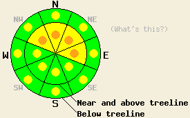
Near and above treeline, avalanche danger is MODERATE on NW-N-NE-E aspects 35 degrees and steeper. Below treeline, pockets of MODERATE danger exist in open wind affected areas 35 degrees and steeper. Near and above treeline, some pockets of CONSIDERABLE danger may develop on NW-N-NE-E aspects 35 degrees and steeper in areas that receive the high end of forecasted snow today. |
|
|
|
Another 1-3 inches of new snow has fallen during the last 24 hours. Snow showers should increase again today due to another low-pressure system moving into CA. The strongest part of this system should impact the Sierra south of the forecast area. However, light snow showers and southwest winds should continue over the Central Sierra today. This system could bring another 3-7 inches of snow to the forecast area over the next 24 hours. The winds should start to decrease this afternoon and shift to the north and east tonight as the low-pressure moves farther south.
Observations in Negro Canyon (Donner Summit area) and in the Bear Valley area yesterday showed a layer of slightly heavier snow on top of lighter snow near the base of the storm snow. In the Bear Valley area this interface seemed to consolidate quickly during the day. By the end of the day ski-cuts on steep, convex test slopes did not produce any failures. In Negro Canyon where the new snow fell on top of a crust, this layer remained more active. Several small, natural and skier-triggered avalanches released within the new snow on wind-loaded, NE-E-facing slopes steeper than 35 degrees. Large, tender cornices that failed several feet away from their edges had also formed in the Negro Canyon area (photos and video).
Avalanche Concerns:
Even though the break in the storm has allowed the weaknesses below yesterday's wind-slabs to gain some strength, more wind and snow today will cause the wind-slabs to grow heavier and more widespread today. The continued wind and snow will also create even larger cornices above wind-loaded slopes. While today's light snowfall may not be enough to cause avalanches on its own, the additional weight of a person on these cornices or the wind-slabs below could easily break the bonds holding them to the slopes today. Human-triggered avalanche activity on wind-loaded slopes steeper than 35 degrees will remain possible both above and below treeline. In the most heavily wind-loaded areas near and above treeline some isolated natural activity could be possible in areas that receive the high end of the forecasted snowfall amounts.
Near and above treeline, avalanche danger is MODERATE on NW-N-NE-E aspects 35 degrees and steeper. Below treeline, pockets of MODERATE danger exist in open wind affected areas 35 degrees and steeper. Near and above treeline, some pockets of CONSIDERABLE danger may develop on NW-N-NE-E aspects 35 degrees and steeper in areas that receive the high end of forecasted snow today.
| 0600 temperature: | 23 deg. F. |
| Max. temperature in the last 24 hours: | 30 deg. F. |
| Average wind direction during the last 24 hours: | Southwest |
| Average wind speed during the last 24 hours: | 30 mph |
| Maximum wind gust in the last 24 hours: | 65 mph |
| New snowfall in the last 24 hours: | 1-3 inches |
| Total snow depth: | 74-110 inches |
For 7000-8000 ft: |
|||
| Saturday: | Saturday Night: | Sunday: | |
| Weather: | Mostly cloudy with scattered snow showers in the morning. Showers becoming more widespread in the afternoon. | Snow in the evening becoming showery after midnight. | Mostly cloudy with scattered snow showers |
| Temperatures: | 28-32 deg. F. | 19-23 deg. F. | 26-31 deg. F. |
| Wind direction: | Southwest shifting to the west | West shifting to the north after midnight | Northeast |
| Wind speed: | 10-15 mph with gusts to 30 mph decreasing to 10 mph in the afternoon | 10 mph | 10-15 mph with gusts to 25 mph |
| Expected snowfall: | 2-4 in. | 1-3 in. | trace in. |
For 8000-9000 ft: |
|||
| Saturday: | Saturday Night: | Sunday: | |
| Weather: | Mostly cloudy with scattered snow showers in the morning. Showers becoming more widespread in the afternoon. | Snow in the evening becoming showery after midnight. | Mostly cloudy with scattered snow showers |
| Temperatures: | 24-29 deg. F. | 15-20 deg. F. | 22-27 deg. F. |
| Wind direction: | Southwest shifting to the west | Northwest shifting to the north after midnight | Northeast |
| Wind speed: | 15-25 mph with gusts to 50 mph decreasing in the afternoon | 10-15 mph with gusts to 30 mph | 10-20 mph with gusts to 30 mph |
| Expected snowfall: | 2-4 in. | 1-3 in. | trace in. |


This website is owned and maintained by the non-profit arm of the Sierra Avalanche Center. Some of the content is updated by the USDA avalanche forecasters including the forecasts and some observational data. The USDA is not responsible for any advertising, fund-raising events/information, or sponsorship information, or other content not related to the forecasts and the data pertaining to the forecasts.

