In partnership with: 
|
February 8, 2010 at 8:01 am |
|
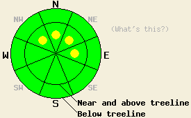
Near and above treeline isolated pockets of MODERATE avalanche danger remain on NW-N-NE-E aspects steeper than 35 degrees. Below treeline the avalanche danger is LOW. |
|
|
|
Another low-pressure sliding down the west coast should start replace the weak high-pressure over the forecast area today. This system should bring increasing cloud cover to the region this afternoon. By tonight the winds should increase shift back to the southwest. The forecast calls snow accumulations of 5 to 11 inches above 7000' by tomorrow afternoon with the heaviest snowfall occurring during the day tomorrow.
Yesterday observations in the Mt. Rose area, in the Donner Summit area, in the Bear Valley area, and on Jake's Peak all continued to indicate that the snowpack is gaining strength in most areas. On Donner Peak some isolated, small shooting cracks did occur on a few steep roll-overs. One small (8in crown) avalanche did occur in this area on a pocket of steep (40 degrees) terrain. In the Bear Valley area near Underwood Bowl and along the east ridge of Tamarack Peak in the Mt. Rose area ski-cuts and weighting test slopes did not cause any signs of instability. Several refrigerator-sized cornice pieces dropped onto N-NE facing, 37-39 degree, wind-loaded slopes along the east ridge of Tamarack Peak did not cause any failures in the slopes below. On Jake's Peak some minor skier-triggered sluffs involving the top 3-4" of snow did occur on steeper (38-40 degree) test slopes. Snowpit information from all of these areas showed good bonding in the recent snow and that the lingering weaknesses continue to grow more inconsistent and harder to break. Observations in these areas also showed several inches of soft, unconsolidated snow remains on most of the northerly aspects. The NE winds did affect the snow surface slightly near ridgelines on the most-exposed N-NE-E aspects. In the Bear Valley area a small melt-freeze crust has started to form on the southerly aspects.
Avalanche Concerns:
Avalanche activity will remain unlikely today in most areas due to continued bonding/settlement within the recent snow, decreased winds, and no new loading over the last 24 hrs. However, some isolated pockets of sensitive wind-slabs where human-triggered avalanches may remain possible could still exist on heavily wind-loaded slopes above treeline. Pockets of instability will be more likely in the Carson Range south and east of Lake Tahoe in areas that received more snow. Use normal caution when traveling in the backcountry.
Near and above treeline isolated pockets of MODERATE avalanche danger remain on NW-N-NE-E aspects steeper than 35 degrees. Below treeline the avalanche danger is LOW.
| 0600 temperature: | 22 deg. F. |
| Max. temperature in the last 24 hours: | 29 deg. F. |
| Average wind direction during the last 24 hours: | Northeast |
| Average wind speed during the last 24 hours: | 10 mph |
| Maximum wind gust in the last 24 hours: | 29 mph |
| New snowfall in the last 24 hours: | O inches |
| Total snow depth: | 73-112 inches |
For 7000-8000 ft: |
|||
| Monday: | Monday Night: | Tuesday: | |
| Weather: | Partly cloudy becoming mostly cloudy with isolated snow showers in the afternoon. | Isolated snow showers in the evening. Snow becoming more widespread after midnight. | Snow |
| Temperatures: | 27-32 deg. F. | 17-22 deg. F. | 23-28 deg. F. |
| Wind direction: | East | Southwest | South shifting to the east in the afternoon. |
| Wind speed: | 10 mph | 10-15 mph with gusts to 25 mph after midnight | 10-15 mph with gusts to 25 mph |
| Expected snowfall: | trace in. | up to 3 in. | 2-8 in. |
For 8000-9000 ft: |
|||
| Monday: | Monday Night: | Tuesday: | |
| Weather: | Partly cloudy becoming mostly cloudy with isolated snow showers in the afternoon. | Isolated snow showers in the evening. Snow becoming more widespread after midnight. | Snow |
| Temperatures: | 23-28 deg. F. | 13-17 deg. F. | 19-24 deg. F. |
| Wind direction: | East | Southwest | South shifting to the east in the afternoon. |
| Wind speed: | 10 mph | 10-15 mph with gusts to 25 mph increasing to 15-25 mph with gusts to 35 mph after midnight | 15-20 mph with gusts to 40 mph |
| Expected snowfall: | trace in. | up to 3 in. | 4-8 in. |


This website is owned and maintained by the non-profit arm of the Sierra Avalanche Center. Some of the content is updated by the USDA avalanche forecasters including the forecasts and some observational data. The USDA is not responsible for any advertising, fund-raising events/information, or sponsorship information, or other content not related to the forecasts and the data pertaining to the forecasts.

