In partnership with: 
|
February 10, 2010 at 7:44 am |
|
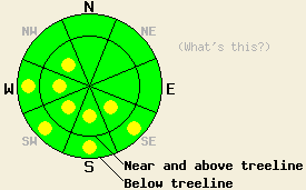
Near and above treeline, pockets of MODERATE avalanche danger exist in wind loaded areas on SE-S-SW-W-NW aspects, 35 degrees and steeper. Below 8,500', pockets of MODERATE avalanche danger will develop in open sun exposed areas on SE-S-SW-W aspects 35 degrees and steeper in response to daytime warming. For all other areas, avalanche danger is LOW. |
|
|
|
High pressure is building over the forecast area this morning. Sunny skies, above freezing air temperatures below 8,000', and light winds are expected by this afternoon. New snow amounts that accumulated mainly yesterday morning range from 1 to 3 inches across the forecast area. Ridgetop winds shifted to the northeast yesterday and increased to moderate in speed overnight. Wind speeds are decreasing this morning with a wind shift to the northwest and west expected this afternoon.
Observations made yesterday on Silver Peak (Pole Creek area) revealed no evidence of instability. Informal tests conducted between 7,200' and 8,300' on N-NE-E aspects above and below treeline found only very minor evidence of slab formation in above treeline areas. No cracking or test slope failure of any kind was observed. In near treeline and below treeline areas the new snow remained unconsolidated with no slab formation. Formal observations made near treeline in a traditionally wind loaded area at 8,030' on a N aspect 32 degree slope yielded no further evidence of instability (pit profile). Several inches of new snow existed on all aspects with plenty of snow available for wind transport.
Avalanche Concern #1:
Northeast ridgetop winds were strong enough to move snow during the past 12 hours. Fresh wind slabs are expected to have formed overnight in near and above treeline areas mainly on SE-S-SW-W-NW aspects. These slabs will likely be 4 to 8 inches deep in many areas, especially below open ridgelines and in gully features.
Avalanche Concern #2:
Air temperatures warming to above freezing in areas below 8,000' may contribute to warming instability as the day progresses. This will mainly occur in open sun exposed areas on SE-S-SW-W aspects below 8,500' near exposed rocks and cliff bands that contribute to increased heating of the recent new snow. A fair amount of roller ball activity is expected today as snow falls off of trees and rocks in sun exposed areas.
Near and above treeline, pockets of MODERATE avalanche danger exist in wind loaded areas on SE-S-SW-W-NW aspects, 35 degrees and steeper. Below 8,500', pockets of MODERATE avalanche danger will develop in open sun exposed areas on SE-S-SW-W aspects 35 degrees and steeper in response to daytime warming. For all other areas, avalanche danger is LOW.
| 0600 temperature: | 18 to 23 deg. F. |
| Max. temperature in the last 24 hours: | 25 to 31 deg. F. |
| Average wind direction during the last 24 hours: | Northeast |
| Average wind speed during the last 24 hours: | 20 mph |
| Maximum wind gust in the last 24 hours: | 48 mph |
| New snowfall in the last 24 hours: | 2 to 3 inches |
| Total snow depth: | 72 to 111 inches |
For 7000-8000 ft: |
|||
| Wednesday: | Wednesday Night: | Thursday: | |
| Weather: | Mostly sunny skies with increasing high clouds in the afternoon. | Mostly cloudy skies. | Mostly cloudy skies. |
| Temperatures: | 30 to 35 deg. F. | 21 to 26 deg. F. | 32 to 37 deg. F. |
| Wind direction: | NE shifting to NW to W | W | SW |
| Wind speed: | 10 to 15 mph with gusts to 25 mph. Winds decreasing to 10 mph in the afternoon. | Around 10 mph. | 10 to 15 mph with gusts to 25 mph in the afternoon. |
| Expected snowfall: | O in. | O in. | O in. |
For 8000-9000 ft: |
|||
| Wednesday: | Wednesday Night: | Thursday: | |
| Weather: | Mostly sunny skies with increasing high clouds in the afternoon. | Mostly cloudy skies. | Mostly cloudy skies. |
| Temperatures: | 23 to 30 deg. F. | 18 to 23 deg. F. | 25 to 32 deg. F. |
| Wind direction: | NE shifting to NW to W | W | W |
| Wind speed: | 15 to 25 mph with gusts to 35 mph. Winds decreasing to 10 mph by the afternoon. | 10 to 15 mph with gusts to 30 mph. | 15 to 25 mph with gusts to 35 mph. Gusts increasing to 45 mph in the afternoon. |
| Expected snowfall: | O in. | O in. | O in. |


This website is owned and maintained by the non-profit arm of the Sierra Avalanche Center. Some of the content is updated by the USDA avalanche forecasters including the forecasts and some observational data. The USDA is not responsible for any advertising, fund-raising events/information, or sponsorship information, or other content not related to the forecasts and the data pertaining to the forecasts.

