In partnership with: 
|
February 13, 2010 at 8:00 am |
|
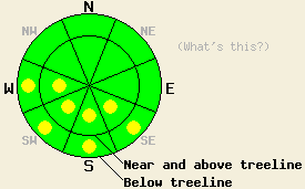
This morning the avalanche danger is LOW for all elevations and aspects. Pockets of MODERATE danger may form on sun-exposed SE-S-SW-W aspects steeper than 35 degrees due to daytime warming today. Use normal caution when traveling in the backcountry. |
|
|
|
The high-pressure ridge over the forecast area should bring warmer temperatures and more sunshine to the region today. The forecast calls for high temperatures of 38-45 degrees F. above 7000' today. The winds started to decrease last night and should continue to weaken during the day today. By tonight more clouds should start to move over the forecast area due to a low-pressure off the Canadian coast. The forecast calls for little to no precipitation from these clouds.
Yesterday, observations from Waterhouse Peak, the south side of Carson Pass, and the Donner Summit area showed shallow (3-6 inches), hard wind-slabs near ridgelines on wind-loaded, N-NE facing slopes near and above treeline. Some human-triggered cracks did occur on a few isolated wind-loaded test slopes on Waterhouse Peak and in the Donner Summit area. However, most of these wind-slabs did not react to the additional weight of a person on top of them. Other observations and snowpit tests in these areas showed a mostly stable snowpack. A sometimes-breakable, sometimes-supportable crust existed on the snow surface up to 8200' on all aspects in these areas. On the southerly aspects this crust persisted up to 9000' on Waterhouse Peak. By mid-day enough melting had occurred for a skier to release some small roller-balls on the lower elevation sun-exposed slopes in the Donner Summit area. Soft, unconsolidated snow remained on the sheltered N-NE aspects above 8200'. A mix of soft snow and hard wind-packed snow existed on exposed N-NE-E aspects above treeline.
Avalanche Concerns:
With daytime highs expected to climb 7-13 degrees higher today than yesterday and more prolonged sunshine, instabilities that form due to daytime warming will comprise the primary avalanche concern today. Most of these wet-snow instabilities should take the form of roller-balls and point-release slides. These slides could entrain enough snow to push a person off course and into trouble. These instabilities will mostly likely exist on sun-exposed SE-S-SW-W aspects below 9000'. Other avalanche activity like wind-slab failure or wet-slab avalanches will remain unlikely but not impossible today. Use normal caution when traveling in the backcountry.
This morning the avalanche danger is LOW for all elevations and aspects. Pockets of MODERATE danger may form on sun-exposed SE-S-SW-W aspects steeper than 35 degrees due to daytime warming today. Use normal caution when traveling in the backcountry.
| 0600 temperature: | 20 deg. F. |
| Max. temperature in the last 24 hours: | 31 deg. F. |
| Average wind direction during the last 24 hours: | West southwest |
| Average wind speed during the last 24 hours: | 30-40 mph |
| Maximum wind gust in the last 24 hours: | 66 mph |
| New snowfall in the last 24 hours: | O inches |
| Total snow depth: | 70-108 inches |
For 7000-8000 ft: |
|||
| Saturday: | Saturday Night: | Sunday: | |
| Weather: | Mostly cloudy this morning becoming mostly sunny this afternoon. | Partly cloudy becoming mostly cloudy. | Mostly cloudy |
| Temperatures: | 38-45 deg. F. | 25-31 deg. F. | 38-45 deg. F. |
| Wind direction: | Southwest | Variable | Southwest |
| Wind speed: | up to 10 mph | Light | up to 10 mph |
| Expected snowfall: | O in. | O in. | O in. |
For 8000-9000 ft: |
|||
| Saturday: | Saturday Night: | Sunday: | |
| Weather: | Mostly cloudy this morning becoming mostly sunny this afternoon. | Partly cloudy becoming mostly cloudy. | Mostly cloudy |
| Temperatures: | 38-44 deg. F. | 23-30 deg. F. | 38-44 deg. F. |
| Wind direction: | Southwest | West shifting to the southwest after midnight | West |
| Wind speed: | 10 mph with gusts to 25 mph | 10 mph with gusts to 25 mph after midnight | 10-15 mph with gusts to 35 mph |
| Expected snowfall: | O in. | O in. | O in. |


This website is owned and maintained by the non-profit arm of the Sierra Avalanche Center. Some of the content is updated by the USDA avalanche forecasters including the forecasts and some observational data. The USDA is not responsible for any advertising, fund-raising events/information, or sponsorship information, or other content not related to the forecasts and the data pertaining to the forecasts.

