In partnership with: 
|
February 18, 2010 at 8:00 am |
|
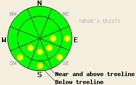
This morning LOW avalanche danger exists for all elevations and aspects. Pockets of MODERATE danger will develop below 9,500' on E-SE-S-SW aspects, 35 degrees and steeper due to daytime warming. |
|
|
|
The forecast calls for another sunny day today with temperatures slightly cooler than yesterday. Daytime highs should only reach into the upper 30's to low 40's above 7000'. The southwest winds which increased yesterday should remain moderate through tomorrow. A low pressure system off the coast should start to affect the forecast area tomorrow and bring some clouds, cooler temperatures, and a slight chance for some isolated afternoon snow showers (more detail and a weather graphic from the NWS here).
Yesterday observations on Cup Lake Peak (near Echo Summit) and Folger Peak (near Ebbetts Pass) both showed 3-5 inches of wet, melt-freeze snow on the SE-S aspects by mid-day. In both of these areas small, wet, skier-triggered sluffs occurred on 35-40 degree, SE facing slopes. None of these sluffs entrained enough snow to pose much of a threat to the skiers. Observers reported roller-balls and point-release slides from earlier in the week in both areas as well. On the northerly aspects a thin, breakable melt-freeze crust existed up to 8800' on sun-exposed slopes in both areas. Below 8000' this crust became thicker and more well defined. On the shadier slopes above 8000' this crust gave way to 2-4" of cold, soft snow. Below the melt-freeze crust and below the wet snow, cold, dry well bonded snow remains on all aspects.
Avalanche Concerns:
Wet-snow instabilities that form due to daytime warming will comprise the main avalanche concern again today. The strong overnight refreeze, today's slightly cooler daytime temperatures, and several days of a melt-freeze cycle should all help make these instabilities smaller and less widespread today. Human-triggered, wet, loose avalanches will remain possible on the most sun-exposed E-SE-S-SW aspects.
This morning LOW avalanche danger exists for all elevations and aspects. Pockets of MODERATE danger will develop below 9,500' on E-SE-S-SW aspects, 35 degrees and steeper due to daytime warming.
| 0600 temperature: | 30 deg. F. |
| Max. temperature in the last 24 hours: | 42-48 deg. F. |
| Average wind direction during the last 24 hours: | West southwest |
| Average wind speed during the last 24 hours: | 20 mph |
| Maximum wind gust in the last 24 hours: | 32 mph |
| New snowfall in the last 24 hours: | O inches |
| Total snow depth: | 66-104 inches |
For 7000-8000 ft: |
|||
| Thursday: | Thursday Night: | Friday: | |
| Weather: | Sunny | Partly cloudy | Mostly cloudy in the morning with a 30% chance of isolated snow showers in the afternoon. |
| Temperatures: | 38-45 deg. F. | 26-32 deg. F. | 32-39 deg. F. |
| Wind direction: | Southwest | Southwest | Southwest |
| Wind speed: | 10-15 mph | 10-15 mph with gusts to 25 mph | 10-15 mph |
| Expected snowfall: | O in. | O in. | trace in. |
For 8000-9000 ft: |
|||
| Thursday: | Thursday Night: | Friday: | |
| Weather: | Sunny | Partly cloudy | Mostly cloudy in the morning with a 30% chance of isolated snow showers in the afternoon. |
| Temperatures: | 36-42 deg. F. | 22-29 deg. F. | 31-37 deg. F. |
| Wind direction: | Southwest | Southwest | Southwest |
| Wind speed: | 10-15 mph with gusts to 30 mph | 10-15 mph with gusts to 30 mph | 10-15 mph with gusts to 25 mph |
| Expected snowfall: | O in. | O in. | trace in. |


This website is owned and maintained by the non-profit arm of the Sierra Avalanche Center. Some of the content is updated by the USDA avalanche forecasters including the forecasts and some observational data. The USDA is not responsible for any advertising, fund-raising events/information, or sponsorship information, or other content not related to the forecasts and the data pertaining to the forecasts.

