In partnership with: 
|
February 21, 2010 at 8:00 am |
|
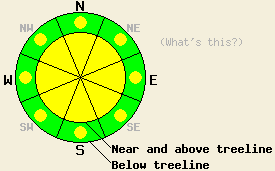
Near and above treeline, avalanche danger in MODERATE on all aspects on slopes 35 degrees and steeper. Below treeline, avalanche danger is LOW with pockets of MODERATE danger in open wind affected areas on all aspects 35 degrees and steeper. A significant variance in localized avalanche danger is anticipated today due to local variances in new snow accumulation. |
|
|
|
A storm system that moved out of ID/MT yesterday and into the forecast area yesterday afternoon continues to bring modest snowfall to the eastern and southern portions of the forecast area this morning. In the Carson Range on the east side of Lake Tahoe, 5 to 8 inches of new snow has fallen since around 1 pm yesterday. Along the Sierra Crest, 4 to 8 inches of new snow has accumulated from roughly Rubicon Peak on the west shore of Lake Tahoe south to Ebbetts Pass. Around 2 to 3 inches of new snow has accumulated along the Sierra Crest in areas north of Rubicon Peak up to Yuba Pass. Up to 14 inches has accumulated in areas around Reno, NV. Air temperatures have shown a cooling trend since the onset of snowfall yesterday afternoon. A second storm system will move into the forecast area today from the west bringing an additional 2 to 6 inches of new snow, mainly along the Sierra Crest. Southwest ridgetop winds were light to moderate in speed yesterday. Winds increased to moderate in speed overnight and are expected to continue today. Winds are forecast to shift to the NE overnight into tomorrow.
Observations made yesterday on Pickett Peak (Luther Pass area) and at Grouse Rocks (Greater Blackwood Canyon area) indicated that the existing snowpack was in good condition to handle new snow loading from the current storm systems (pit profile, photos, video, more info). New snow has fallen on a mix of crust and unconsolidated snow surfaces with graupel noted at the bottom of the new snow layer in both areas. Fair to poor bonding of new snow to crusted old snow surfaces was reported yesterday afternoon on Mt. Tallac (Emerald Bay area) on a SE aspect at 8,400' (more info). Increasing winds overnight are expected to have caused significant drifting of new snow along ridgetops.
Avalanche Concerns:
Avalanche concerns for today focus on new snow. A significant variance in localized avalanche danger is anticipated today due to local variances in new snow accumulation. Up to 8 inches of new snow fell yesterday afternoon under light winds, allowing for significant accumulation on all aspects. This new snow had a high water content, allowing it to form slabs easily. Bonding at the old/new snow interface is expected to have gained strength overnight, but the presence of graupel near the base of the new snow will likely slow down this gain in strength. Increasing winds overnight will have deposited additional snow in lee areas mainly on NW-N-NE-E-SE aspects in open near treeline areas and in above treeline areas. Additional new snowfall today will add to the size of existing slabs. Human triggered avalanches should be anticipated today on all aspects in areas where several inches of new snow has accumulated. In areas that have received the highest amounts of new snow, isolated natural avalanche activity is unlikely but not impossible in wind loaded areas.
Near and above treeline, avalanche danger in MODERATE on all aspects on slopes 35 degrees and steeper. Below treeline, avalanche danger is LOW with pockets of MODERATE danger in open wind affected areas on all aspects 35 degrees and steeper. A significant variance in localized avalanche danger is anticipated today due to local variances in new snow accumulation.
| 0600 temperature: | 17 to 21 deg. F. |
| Max. temperature in the last 24 hours: | 25 to 31 deg. F. |
| Average wind direction during the last 24 hours: | Southwest |
| Average wind speed during the last 24 hours: | 15 mph |
| Maximum wind gust in the last 24 hours: | 45 mph |
| New snowfall in the last 24 hours: | 3 to 8 inches |
| Total snow depth: | 69 to 108 inches |
For 7000-8000 ft: |
|||
| Sunday: | Sunday Night: | Monday: | |
| Weather: | Cloudy skies with snow in the morning. Numerous snow showers in the afternoon. | Cloudy skies with snow showers in the evening. Scattered snow showers after midnight. | Mostly cloudy skies with a chance of snow showers in the morning. |
| Temperatures: | 20 to 27 deg. F. | 6 to 13 deg. F. | 22 to 29 deg. F. |
| Wind direction: | SW | NW shifting to E | E |
| Wind speed: | 10 to 20 mph with gusts to 30 mph. | Around 10 mph. | 10 to 15 mph with gusts to 25 mph. |
| Expected snowfall: | 2 to 5 in. | 2 to 4 in. | 0 to trace in. |
For 8000-9000 ft: |
|||
| Sunday: | Sunday Night: | Monday: | |
| Weather: | Cloudy skies with snow in the morning. Numerous snow showers in the afternoon. | Cloudy skies with snow showers in the evening. Scattered snow showers after midnight. | Mostly cloudy skies with a chance of snow showers in the morning. |
| Temperatures: | 19 to 25 deg. F. | 3 to 10 deg. F. | 18 to 25 deg. F. |
| Wind direction: | SW | W shifting to NE | NE |
| Wind speed: | 20 to 30 mph with gusts to 45 mph. | 15 to 25 mph with gusts to 40 mph. | 10 to 15 mph with gusts to 30 mph. |
| Expected snowfall: | 3 to 6 in. | 3 to 5 in. | 0 to trace in. |


This website is owned and maintained by the non-profit arm of the Sierra Avalanche Center. Some of the content is updated by the USDA avalanche forecasters including the forecasts and some observational data. The USDA is not responsible for any advertising, fund-raising events/information, or sponsorship information, or other content not related to the forecasts and the data pertaining to the forecasts.

