In partnership with: 
|
February 27, 2010 at 7:58 am |
|
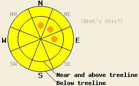
Near and above treeline, avalanche danger is MODERATE with pockets of CONSIDERABLE danger on N-NE-E aspects 35 degrees and steeper. Below treeline, avalanche danger is MODERATE on all slopes 35 degrees and steeper. Large destructive avalanches are possible today. |
|
|
|
The significant storm system that passed to the south of the forecast area is winding down this morning. Cold front passage occurred in the Lake Tahoe Basin between 4 and 5 pm yesterday turning rain to snow. Southwest ridgetop winds have been steadily decreasing in speed post cold front passage and have become light this morning. Since 11 pm last night, air temperatures have shown a cooling trend and snowfall rates have tapered off significantly. The bulk of the new snow accumulation across the forecast area in the past 24 hours occurred between 5 and 11 pm yesterday. The Sierra Crest above 6,800' was targeted and spillover to the Carson Range was better than expected with 7 to 13 inches of new snow in areas north of Hwy 88 and 11 to 16 inches of new snow in areas south of Hwy 88. Continued snow showers with an additional 1 to 4 inches of new snow, light to moderate southwest ridgetop winds, and below freezing air temperatures are expected for today.
Observations made yesterday on Elephant's Back (Carson Pass area) showed increasing SW winds with significant blowing snow occurring in near and above treeline areas by 10am. Snowpit data taken above treeline on a NE aspect at 9,200' indicated that snowpack failure and fracture propagation remained likely at the base of a wind slab within the old snow (photos, video, more info). Observations made on Tamarack Peak (Mount Rose area) also showed significant blowing snow during the early afternoon hours. Snowpit data collected in near treeline terrain at 9,900' on a N aspect 38 slope showed less evidence of snowpack instability and indicated unlikely fracture propagation within the Feb 19-24 snowfall layers (pit profile, more info).
Avalanche Concern #1:
New slabs formed on a variety of aspects yesterday and overnight both above and below treeline. The fairly high water content of the new snow is expected to have formed cohesive slabs allowing for fracture propagation to travel significant distances today. The best widow for natural avalanche activity has already occurred, but human triggered avalanches large enough to bury or injure a person are expected to continue today. The greatest areas of instability are expected near and above treeline on recently wind loaded N-NE-E aspects. Cross loaded NW and SE aspects remain highly suspect as well.
Avalanche Concern #2:
Deep slab avalanches are possible in areas where avalanche activity over the past week (photos, more info) did not remove the Feb 19-24 snow layers. Recent avalanche activity was noted to initiate within the Feb 24 storm snow and then step down to the base of the Feb 19 layer in many areas. This continued step down deep slab instability remains possible today as avalanches initiate within the new snow from the past 24 hours and then step down into deeper old snow layers. This will serve to increase the size and destructive potential of avalanches in areas where this occurs. The Feb 19 layer is anywhere from 2 to 4+ feet deep in the snowpack at this time.
Near and above treeline, avalanche danger is MODERATE with pockets of CONSIDERABLE danger on N-NE-E aspects 35 degrees and steeper. Below treeline, avalanche danger is MODERATE on all slopes 35 degrees and steeper. Large destructive avalanches are possible today.
| 0600 temperature: | 26 deg. F. |
| Max. temperature in the last 24 hours: | 35 to 38 deg. F. |
| Average wind direction during the last 24 hours: | Southwest |
| Average wind speed during the last 24 hours: | 60 mph |
| Maximum wind gust in the last 24 hours: | 110 mph |
| New snowfall in the last 24 hours: | 8 to 16 inches |
| Total snow depth: | 85 to 121 inches |
For 7000-8000 ft: |
|||
| Saturday: | Saturday Night: | Sunday: | |
| Weather: | Cloudy skies with snow showers. | Partly cloudy skies with a slight chance of snow showers in the evening. | Sunny skies. |
| Temperatures: | 24 to 30 deg. F. | 15 to 20 deg. F. | 30 to 37 deg. F. |
| Wind direction: | SW | N | NE |
| Wind speed: | 10 to 15 mph with gusts to 25 mph in the morning. Winds decreasing to 10 mph or less by afternoon. | Around 10 mph. | Around 10 mph in the afternoon. |
| Expected snowfall: | 1 to 3 in. | 0 to trace in. | O in. |
For 8000-9000 ft: |
|||
| Saturday: | Saturday Night: | Sunday: | |
| Weather: | Cloudy skies with snow showers. | Partly cloudy skies with a slight chance of snow showers in the evening. | Sunny skies. |
| Temperatures: | 20 to 25 deg. F. | 18 to 23 deg. F. | 22 to 28 deg. F. |
| Wind direction: | SW | NE | NE |
| Wind speed: | 10 to 20 mph. Gusts to 35 mph in the morning decreasing to 25 mph by afternoon. | 10 to 15 mph with gusts to 25 mph. | 10 to 15 mph with gusts to 25 mph in the afternoon. |
| Expected snowfall: | 2 to 4 in. | 0 to trace in. | O in. |


This website is owned and maintained by the non-profit arm of the Sierra Avalanche Center. Some of the content is updated by the USDA avalanche forecasters including the forecasts and some observational data. The USDA is not responsible for any advertising, fund-raising events/information, or sponsorship information, or other content not related to the forecasts and the data pertaining to the forecasts.

