In partnership with: 
|
March 4, 2010 at 8:00 am |
|
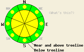
Near and above treeline on slopes 35 degrees and steeper, the avalanche danger is MODERATE on all aspects. Below treeline pockets of MODERATE danger exist on all aspects on slopes steeper than 35 degrees. Large destructive avalanches remain possible. |
|
|
|
During the day yesterday, another 10-12 inches of snow fell along the Sierra Crest north of Carson Pass. Areas south of Carson Pass to Ebbetts Pass reported 12-16 inches of new snow yesterday. Most of the intense snowfall remained west of Lake Tahoe with remote sensors in the Mt. Rose area and in the Carson Range south and east of the lake only reporting 2-3 inches of new snow over the last 24 hours. Snowfall tapered off yesterday evening. The winds remained strong and out of the southwest until mid to late afternoon yesterday. After that the wind speed decreased and the winds became variable in direction. This storm should continue to move east today allowing a high-pressure ridge to build over the area through tomorrow. The forecast calls for mostly sunny skies, light winds, and colder than average temperatures through tonight. Some clouds should start to build over the area by tomorrow afternoon.
Observations from the Munchkins area, Grouse Rocks area (both near Alpine Meadows), Hidden Peak, and Pickett Peak (Luther Pass area) all indicated that weak bonding existed between yesterday's new snow and the snow below it. Skier triggered shooting cracks and sluffs occurred in all of these areas. On Pickett Peak a skier dropped a piece of a cornice onto a small wind-loaded test slope and triggered the release of a small slab. On a nearby test slope a natural cornice failure resulted in similar activity. Along with the widespread signs of unstable snow, several avalanches with crowns about 1 ft deep were reported in the Munchkins area. In the Mt. Rose area more stable conditions existed due to less snow accumulation. Snowpits in the Mt. Rose area and in the Grouse Rocks area indicated that the Feb. 19th layer has gained strength in those areas.
Avalanche Concern #1:
Bonding between the snow that fell yesterday and the snow below it will remain suspect today. Observations yesterday indicated that additional weight on the snowpack (a person, a cornice, etc.) could break these bonds. Human-triggered avalanche activity resulting from these weak bonds will remain possible today especially on wind-loaded N-NE-E aspects and cross-loaded SE and NW aspects near and above treeline where the winds have formed wind slabs and cornices on the leeward slopes. Human-triggered soft slab avalanches will also remain possible below treeline on steep open slopes due to the weak bonds between the new snow and the snow below it. These avalanches could step down to the Feb. 19th interface resulting in large destructive slides.
Avalanche Concern #2:
Today avalanches resulting from the intense March sun on the new snow will be possible. The sun-exposed, cross-loaded SE aspects hold the most potential for this type of avalanche activity. These avalanches could take the form of slabs or point-releases and sluffs.
Avalanche Concern #3:
Even though human-triggered avalanche activity due to weakness at the Feb 19th interface is becoming less likely, deep slab avalanches will remain possible in isolated areas today. This interface had barely strengthened to the point where it could support support the snowpack before the storm. Areas of complex terrain near and above treeline on northerly aspects hold the most potential for triggering these large, deep avalanches. However, these types of slides are not impossible on any steep NW-N-NE facing slopes where this interface remains weak and where the slopes have not already slid. The type of snow layer at this interface and its location, strength, and distribution varies greatly across the forecast area. Digging snowpits down to the older snow and testing the bonding at the Feb 19th interface can help determine whether or not worrisome weaknesses exist at this interface.
Near and above treeline on slopes 35 degrees and steeper, the avalanche danger is MODERATE on all aspects. Below treeline pockets of MODERATE danger exist on all aspects on slopes steeper than 35 degrees. Large destructive avalanches remain possible.
| 0600 temperature: | 13 deg. F. |
| Max. temperature in the last 24 hours: | 22 deg. F. |
| Average wind direction during the last 24 hours: | Southwest until yesterday after 3 pm. Variable between SW, W, NW, and N after that. |
| Average wind speed during the last 24 hours: | Southwest: 25-35 mph | Variable: 5-15 mph |
| Maximum wind gust in the last 24 hours: | 72 mph |
| New snowfall in the last 24 hours: | East of Lake Tahoe: 2-4 inches | Along the Sierra Crest: 10-16 inches |
| Total snow depth: | 94-127 inches |
For 7000-8000 ft: |
|||
| Thursday: | Thursday Night: | Friday: | |
| Weather: | Mostly sunny with a few areas of clouds lingering over the mountains. | Partly cloudy | Mostly cloudy in the morning with clouds becoming more widespread in the afternoon. |
| Temperatures: | 26-31 deg. F. | 15-24 deg. F. | 22-28 deg. F. |
| Wind direction: | Northwest | West | Southwest |
| Wind speed: | 10-15 mph with gusts to 25 mph | 10 mph becoming light after midnight | 10 mph |
| Expected snowfall: | O in. | O in. | O in. |
For 8000-9000 ft: |
|||
| Thursday: | Thursday Night: | Friday: | |
| Weather: | Mostly sunny with a few areas of clouds and lingering over the mountains. | Partly cloudy | Mostly cloudy in the morning with clouds becoming more widespread in the afternoon. |
| Temperatures: | 21-25 deg. F. | 13-20 deg. F. | 23-28 deg. F. |
| Wind direction: | Northwest | West | Southwest |
| Wind speed: | 10-15 mph with gusts to 25 mph | 10 mph becoming light after midnight | 10-15 mph with gusts to 30 mph |
| Expected snowfall: | O in. | O in. | O in. |


This website is owned and maintained by the non-profit arm of the Sierra Avalanche Center. Some of the content is updated by the USDA avalanche forecasters including the forecasts and some observational data. The USDA is not responsible for any advertising, fund-raising events/information, or sponsorship information, or other content not related to the forecasts and the data pertaining to the forecasts.

