In partnership with: 
|
March 8, 2010 at 8:02 am |
|
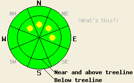
Near and above treeline, pockets of MODERATE avalanche danger will develop on NW-N-NE-E facing slopes steeper than 35 degrees as more snow and wind impact the forecast area this afternoon. Very isolated areas of deep slab instability linger above treeline on NW-N-NE aspects in rocky terrain, 40 degrees and steeper. Below treeline the avalanche danger should remain LOW. If more snow falls than the forecast calls for, the avalanche danger will increase and become more widespread. |
|
|
|
The first of two small low-pressure systems should move into the region this afternoon. Last night the winds shifted back to the west southwest and increased ahead of this system. These winds should remain strong through tonight. Temperatures should start to fall today with afternoon temperatures falling into the teens above 8000'. The forecast calls for up to 6 inches of snow for the Sierra Crest in the next 24 hours. Snowfall should start this afternoon and continue through midnight tonight. This system should move out to the region overnight. Click here for a web graphic from the Reno NWS showing this system and its impacts.
Yesterday, crown profiles on Saturday's skier-triggered avalanche in the Mini Hall (a steep NW facing chute) showed that the avalanche occurred on the 55-degree, north-facing, mostly-unsupported, wall of this chute. The crown ranged in depth from 6 inches near the rocks where the skier triggered the slide to 2.5 ft on the other end of the slide. This slide was only about 30 ft wide at the crown (photos and video). A thin layer of small, weak sugary snow grains at the Feb 19th interface broke when the skier weighted the shallow, unsupported side of the slope and the fracture propagated along this layer into the deeper part of the slope. Layer bonding tests and fracture propagation tests at the crown indicated that breaking this weak layer in the deeper area of the snowpack requires a large amount of force. However, the same tests in shallow part of the snowpack where the weak layer is much closer to the surface showed that small amounts of force (like a person) could still break this layer. These tests also showed that once this layer breaks the fracture could still propagate through the snowpack from shallow areas to deeper areas along this layer. Observations on other less steep N-NW aspects on Angora Peak indicated a mostly stable snowpack. A melt-freeze crust had formed on the snow surface up to 8000' on the more sun-exposed, westerly aspects. This crust remained supportable until mid-afternoon when the sun turned it into wet, heavy snow. This melt-freeze crust also existed on most slopes below 7000' in this area. Above 8000', on the N-NW aspects 4-6 inches of soft unconsolidated snow existed on the surface.
Avalanche concern #1: New wind slabs
With more wind and snow forecasted over the next 24 hours, wind slabs will again rise to the top of the avalanche concern list. Small wind slabs will start to form on the wind-loaded NW-N-NE-E aspects near and above treeline once the snow starts. Even though natural avalanches will remain unlikely today due to a lack of new snow, adding a person on top of these slabs could cause them to break away from the snowpack as small avalanches later today. Any of these avalanches that do occur should remain small today due to a lack of significant new snow accumulation. However, even small avalanches have the potential for serious consequences in the the right kind of terrain, as Saturday's slide on Angora Peak illustrates. If more snow falls than forecasted these wind slabs will grow larger, more widespread, and easier to trigger. Avalanches resulting from failure of these wind-slabs could still step down to the Feb 19th layer in isolated areas of complex, steep terrain.
Avalanche Concern #2: Deep slabs
Very isolated areas of deep slab instability still lurk above treeline on pockets of very steep (over 40 degrees), rocky, complex terrain on NW-N-NE aspects where a shallow snowpack allows the Feb 19 weak layer to live closer to to the surface. Human triggered avalanche activity on this layer remains unlikely except in these very isolated pockets of extreme terrain where a trigger in the right spot on the slope could still break the bonds between this weak layer and the snow above it.
Near and above treeline, pockets of MODERATE avalanche danger will develop on NW-N-NE-E facing slopes steeper than 35 degrees as more snow and wind impact the forecast area this afternoon. Very isolated areas of deep slab instability linger above treeline on NW-N-NE aspects in rocky terrain, 40 degrees and steeper. Below treeline the avalanche danger should remain LOW. If more snow falls than the forecast calls for, the avalanche danger will increase and become more widespread.
| 0600 temperature: | 23 deg. F. |
| Max. temperature in the last 24 hours: | 39 deg. F. |
| Average wind direction during the last 24 hours: | Northeast shifting to the west and southwest after 6 pm yesterday |
| Average wind speed during the last 24 hours: | Northeast: 10 mph | West southwest: 30-35 mph |
| Maximum wind gust in the last 24 hours: | 70 mph |
| New snowfall in the last 24 hours: | O inches |
| Total snow depth: | 86-121 inches |
For 7000-8000 ft: |
|||
| Monday: | Monday Night: | Tuesday: | |
| Weather: | Scattered snow showers this morning. Snow becoming likely this afternoon. Temperatures falling during the afternoon. | Snow likely in the evening. Snow showers tapering off and becoming scattered after midnight. | Mostly cloudy |
| Temperatures: | 27-35 deg. F. | 7-17 deg. F. | 19-26 deg. F. |
| Wind direction: | Southwest | Southwest shifting to the west after midnight | Northwest shifting to the west |
| Wind speed: | 10-15 mph with gusts to 30 mph increasing to 20-30 mph with gusts to 50 mph | 15-25 mph with gusts to 40 mph decreasing to 10 mph after midnight | 5-10 mph with gusts to 25 mph |
| Expected snowfall: | up to 3 in. | up to 3 in. | O in. |
For 8000-9000 ft: |
|||
| Monday: | Monday Night: | Tuesday: | |
| Weather: | Scattered snow showers this morning. Snow becoming likely this afternoon. Temperatures falling to 12-17 degrees during the afternoon. | Snow likely in the evening. Snow showers tapering off and becoming scattered after midnight. | Mostly cloudy |
| Temperatures: | 21-27 deg. F. | 4-12 deg. F. | 11-19 deg. F. |
| Wind direction: | Southwest | Southwest | West |
| Wind speed: | 30-50 mph with gusts to 70 mph | 25-40 mph with gusts to 60 mph decreasing to 15-25 mph with gusts to 40 mph after midnight | 10-20 mph with gusts to 30 mph |
| Expected snowfall: | up to 3 in. | up to 3 in. | O in. |


This website is owned and maintained by the non-profit arm of the Sierra Avalanche Center. Some of the content is updated by the USDA avalanche forecasters including the forecasts and some observational data. The USDA is not responsible for any advertising, fund-raising events/information, or sponsorship information, or other content not related to the forecasts and the data pertaining to the forecasts.

