In partnership with: 
|
March 11, 2010 at 7:21 am |
|
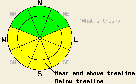
Areas of MODERATE avalanche danger will exist today at all elevations on sun exposed E-SE-S-SW-W aspects, 35 degrees and steeper. For all other areas, avalanche danger is LOW. |
|
|
|
Sunny skies, light winds, and air temperatures near and above freezing are expected for today. Ridgetop winds shifted from northeast to northwest overnight and have become light. Warming at the mid and upper elevations began around 1 am this morning in response to the shift to a more westerly flow aloft. A dramatic change in the weather will occur tomorrow as winds and precipitation chances increase ahead of an approaching storm system.
Observations made yesterday on Powerhouse Peak (Luther Pass area) showed that moderate NE ridgetop winds were scouring snow from northerly aspects and creating some light wind loading on E-SE-S-SW-W aspects in near and above treeline areas. Cornices that had previously formed on N-NE aspects were weak, but intentional collapse of these cornices onto the slopes below yielded no significant signs of slab instability. Snowpit data collected near treeline at 9,230' on a N aspect 37 degree previously wind loaded slope revealed no additional evidence of slab instability (pit profile, more info). Observations made on Donner Peak (Donner Summit area) in near treeline terrain at 7,500' on N-NE-E aspects also revealed no significant evidence of slab instability. Some small natural point release avalanches were observed on N-NE-E aspects during the morning hours and a few roller balls were noted in more direct sun exposed areas during the afternoon hours (photos, more info).
Avalanche concern #1: Warming instability
The combination of warming air temperatures and March solar radiation is expected to create areas of warming instability today. Small natural point release avalanches are possible in sun exposed areas, especially near exposed rocks. Larger human triggered wet loose snow avalanches are expected today in sun exposed areas, mainly on E-SE-S-SW-W aspects. Small human triggered slab avalanches are possible in areas that received wind loading yesterday under NE winds. Recently wind loaded areas near and above treeline that see significant warming today on E-SE-S-SW-W will be the most suspect for slab activity. This instability should be limited to the top layer of recent new snow.
Avalanche Concern #2: Deep slab instabilty
Failure of the slow to bond February 19 weak layer that exists 2 to 4 feet deep in the snowpack remains a lingering concern in very, very isolated areas. If this weak layer is to be found, it will likely be in the southern half of the forecast area in near and above treeline terrain between 8,000' to 9,000' on NW-N-NE aspects that are steeper than 40 degrees and have exposed rocks. Any avalanche activity that occurs on this weak layer will occur within larger areas of seemingly stable snow.
Areas of MODERATE avalanche danger will exist today at all elevations on sun exposed E-SE-S-SW-W aspects, 35 degrees and steeper. For all other areas, avalanche danger is LOW.
| 0600 temperature: | 16 to 26 deg. F. |
| Max. temperature in the last 24 hours: | 26 to 28 deg. F. |
| Average wind direction during the last 24 hours: | Northeast shifting to northwest |
| Average wind speed during the last 24 hours: | 15 mph |
| Maximum wind gust in the last 24 hours: | 35 mph |
| New snowfall in the last 24 hours: | 0 to 1 inches |
| Total snow depth: | 93 to 125 inches |
For 7000-8000 ft: |
|||
| Thursday: | Thursday Night: | Friday: | |
| Weather: | Partly cloudy skies. | Partly cloudy skies. | Mostly cloudy skies with a chance of snow. |
| Temperatures: | 34 to 39 deg. F. | 25 to 30 deg. F. | 32 to 37 deg. F. |
| Wind direction: | NW shifting to SW | SW | SW |
| Wind speed: | Light winds | 10 to 15 mph with gusts to 25 mph after midnight. | 15 to 25 mph with gusts to 40 mph. Winds increasing to 25 to 35 mph with gusts to 50 mph in the afternoon. |
| Expected snowfall: | O in. | O in. | Up to 6 in. |
For 8000-9000 ft: |
|||
| Thursday: | Thursday Night: | Friday: | |
| Weather: | Partly cloudy skies. | Partly cloudy skies. | Mostly cloudy skies with a chance of snow. |
| Temperatures: | 30 to 35 deg. F. | 23 to 28 deg. F. | 25 to 30 deg. F. |
| Wind direction: | NW shifting to SW | SW | SW |
| Wind speed: | 10 to 15 mph | 15 to 25 mph with gusts to 40 mph after midnight. | 30 to 45 mph with gusts to 70 mph. Winds increasing to 50 to 70 mph with gusts to 100 mph in the afternoon. |
| Expected snowfall: | O in. | O in. | Up to 6 in. |


This website is owned and maintained by the non-profit arm of the Sierra Avalanche Center. Some of the content is updated by the USDA avalanche forecasters including the forecasts and some observational data. The USDA is not responsible for any advertising, fund-raising events/information, or sponsorship information, or other content not related to the forecasts and the data pertaining to the forecasts.

