In partnership with: 
|
March 19, 2010 at 6:40 am |
|
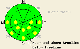
Early this morning, avalanche danger is LOW for all elevations and aspects. Pockets of MODERATE avalanche danger will develop at all elevations on E-SE-S-SW-W aspects 37 degrees and steeper in response to daytime warming. |
|
|
|
High pressure is building over the forecast area. Sunny skies, above freezing air temperatures and decreasing winds are expected for today. Ridgetop winds remain moderate in speed out of the northeast this morning and are expected to shift to the north and become light to moderate in speed this afternoon. Remote sensors are reporting air temperatures above 8,000' in the upper 20s this morning.
Observations made yesterday on Silver Peak (Pole Creek area) showed snow surface conditions that were a mix of melt freeze snow at all elevations on E-SE-S-SW-W aspects and cold snow not affected by melt freeze on N-NE aspects above 8,200'. This is very similar to snow surface conditions seen in other areas over the past few days (more info). Snowpit data collected at 7,900' on a large open ESE aspect 30 degree slope revealed a snowpack that was around 4 feet deep and showed evidence of past and present free water at all heights within the snowpack. Free water drainage from the snowpack appeared established at this location (pit profile, more info). Clear skies last night and below freezing air temperatures are expected to have allowed for a strong overnight refreeze of surface snow.
Avalanche concerns: Warming instability
Avalanche concerns for today continue to focus on wet snow instability. Expect areas of instability to form, especially by mid afternoon on E-SE-S-SW-W aspects at all elevations. Very isolated areas of wet snow instability are possible on NW-N-NE aspects below 7,500'. Any instability will most likely take the form of loose snow avalanches involving the top few inches of wet surface snow. Deep wet slab instability remains unlikely at this time.
Early this morning, avalanche danger is LOW for all elevations and aspects. Pockets of MODERATE avalanche danger will develop at all elevations on E-SE-S-SW-W aspects 37 degrees and steeper in response to daytime warming.
| 0600 temperature: | 26 to 30 deg. F. |
| Max. temperature in the last 24 hours: | 41 to 43 deg. F. |
| Average wind direction during the last 24 hours: | Northeast |
| Average wind speed during the last 24 hours: | 35 mph |
| Maximum wind gust in the last 24 hours: | 63 mph |
| New snowfall in the last 24 hours: | O inches |
| Total snow depth: | 85 to 123 inches |
For 7000-8000 ft: |
|||
| Friday: | Friday Night: | Saturday: | |
| Weather: | Sunny skies. | Clear skies. | Sunny skies. |
| Temperatures: | 43 to 50 deg. F. | 26 to 32 deg. F. | 48 to 55 deg. F. |
| Wind direction: | NE shifting to N | Variable | SW |
| Wind speed: | 10 to 15 mph with gusts to 30 mph. | Light winds | Light winds increasing to 10 to 15 mph in the afternoon. |
| Expected snowfall: | O in. | O in. | O in. |
For 8000-9000 ft: |
|||
| Friday: | Friday Night: | Saturday: | |
| Weather: | Sunny skies. | Clear skies. | Sunny skies. |
| Temperatures: | 42 to 48 deg. F. | 26 to 32 deg. F. | 44 to 51 deg. F. |
| Wind direction: | NE shifting to N | NW shifting to NE after midnight. | SW |
| Wind speed: | 15 to 25 mph with gusts to 65 mph in the morning. Winds decreasing to 10 to 15 mph with gusts to 35 mph in the afternoon. | Up to 10 mph. | Up to 10 mph in the morning. Winds increasing to 10 to 15 mph with gusts to 25 mph in the afternoon. |
| Expected snowfall: | O in. | O in. | O in. |


This website is owned and maintained by the non-profit arm of the Sierra Avalanche Center. Some of the content is updated by the USDA avalanche forecasters including the forecasts and some observational data. The USDA is not responsible for any advertising, fund-raising events/information, or sponsorship information, or other content not related to the forecasts and the data pertaining to the forecasts.

