In partnership with: 
|
March 20, 2010 at 7:01 am |
|
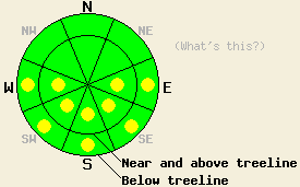
This morning, LOW avalanche danger exists for all elevations and aspects. Pockets of MODERATE avalanche danger will quickly develop at all elevations on E-SE-S-SW-W aspects 37 degrees and steeper in response to daytime warming. |
|
|
|
Remote sensors above 8000' reported overnight lows between 37 and 40 degrees F (several degrees above freezing). Below 7000' the sensors reported overnight lows in the low 30's indicating a slight temperature inversion. The high pressure over the forecast area will keep temperatures warm with daytime highs forecasted to reach into the upper 40's to mid 50's at all elevations again today. The winds should remain light but shift to the southwest. By tomorrow, some cloud cover could develop over the area due to a low-pressure system approaching the Pacific Northwest.
Yesterday morning a hard, supportable, thick, frozen crust existed on the snow surface on the E-SE-S-SW-W aspects due to a solid refreeze the night before. By 10:30 am on Rose Knob Peak, enough melting had occurred for 2-4 inches of soft "corn" snow to form on the sun-exposed E-SE-S aspects between 9700' and 7400'. In the more shaded areas the snow surface remained frozen all the way down to 7400' until at least 11 am. Cold, dry snow still remained on the northerly aspects above 9000'. On the more exposed northerly slopes, a mix of wind scoured surfaces and wind packed snow existed on the snow surface. Softer snow may still exist on high-elevation sheltered northerly aspects. Similar snow surface conditions have been observed in other areas over the past few days (more info).
Avalanche concerns: Warming instability
Even though air temperatures remained above freezing last night, clear skies will have allowed the snowpack to lose enough heat for a decent overnight refreeze (radiational cooling). This refreeze will not be as strong as yesterday's. The snow surface should melt and soften more quickly this morning as the sun hits the snow and the air temperatures start to climb. Enough melting and warming could occur for wet-snow instabilities to form today on the sun-exposed E-SE-S-SW-W aspects. Very isolated areas of wet-snow instability are possible on NW-N-NE aspects below 7,500'. These wet-snow instabilities will most likely manifest as loose snow avalanches, roller-balls, and pinwheels involving the top few inches of wet surface snow. Sinking into wet snow above your boot tops indicates that enough melting has occurred for wet-snow instabilities to pose a threat and that the time has come to move on to a less melted more supportable aspect.
This morning, LOW avalanche danger exists for all elevations and aspects. Pockets of MODERATE avalanche danger will quickly develop at all elevations on E-SE-S-SW-W aspects 37 degrees and steeper in response to daytime warming.
| 0600 temperature: | 38 deg. F. |
| Max. temperature in the last 24 hours: | 50-54 deg. F. |
| Average wind direction during the last 24 hours: | Northeast shifting to the southwest yesterday afternoon/evening |
| Average wind speed during the last 24 hours: | Northeast: 15 mph | Southwest: 10 mph |
| Maximum wind gust in the last 24 hours: | 35 mph |
| New snowfall in the last 24 hours: | O inches |
| Total snow depth: | 85-121 inches |
For 7000-8000 ft: |
|||
| Saturday: | Saturday Night: | Sunday: | |
| Weather: | Sunny | Clear | Partly cloudy |
| Temperatures: | 49-56 deg. F. | 23-30 deg. F. | 43-50 deg. F. |
| Wind direction: | Southwest | Southwest | Southwest |
| Wind speed: | 10 mph | 10-15 mph | 10-15 mph with gusts to 25 mph increasing to 10-20 mph with gusts to 30 mph |
| Expected snowfall: | O in. | O in. | O in. |
For 8000-9000 ft: |
|||
| Saturday: | Saturday Night: | Sunday: | |
| Weather: | Sunny | Clear | Partly cloudy |
| Temperatures: | 49-55 deg. F. | 22-29 deg. F. | 42-48 deg. F. |
| Wind direction: | Southwest | Southwest | Southwest |
| Wind speed: | 10-15 mph with gusts to 25 mph | 15-25 mph decreasing to 10-15 mph with gusts to 35 mph after midnight | 10-15 mph with gusts to 30 mph increasing to 20-30 mph with gusts to 45 mph in the afternoon |
| Expected snowfall: | O in. | O in. | O in. |


This website is owned and maintained by the non-profit arm of the Sierra Avalanche Center. Some of the content is updated by the USDA avalanche forecasters including the forecasts and some observational data. The USDA is not responsible for any advertising, fund-raising events/information, or sponsorship information, or other content not related to the forecasts and the data pertaining to the forecasts.

