In partnership with: 
|
March 21, 2010 at 7:00 am |
|
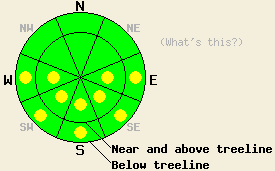
LOW avalanche danger exists for all elevations and aspects. Some isolated pockets of MODERATE avalanche danger may develop on sun-exposed E-SE-S-SW-W aspects 37 degrees and steeper below 9000' due to daytime warming if the forecast area receives more sun than forecasted or the temperatures climb higher than forecasted. |
|
|
|
The southwest winds increased yesterday and last night due to a low-pressure system north of the forecast area. These southwest winds should continue to increase today with winds along the ridge tops averaging 35-55 mph and gusts reaching up to 100 mph. This low pressure should also push a thick layer of high clouds over the region today. The forecast calls for daytime highs to only reach into the upper 30's and low 40's above 7000' today. By tomorrow, a dry cold front should settle over the region causing the winds and temperatures to decrease.
Yesterday, a layer of thin high clouds and strong winds prevented most of the snow surfaces above 7500' from thawing very much. On Red Lake Peak near Carson Pass only 1/2 to 1 inch of soft corn snow had formed on the surface of the sun-exposed E-SE-S aspects between 8600' and 9600' by 1pm. Below this several inches of firm frozen melt/freeze snow existed. The less sun-exposed aspects remained frozen. On the exposed northerly aspects a mix of wind-scoured and wind packed snow surfaces existed. Observations from lower elevation areas west of the forecast area near Cisco Grove (west of Donner Summit) showed that a sometimes breakable, sometimes supportable melt freeze crust existed on the northerly aspects up to 7800'. The E-SE-S aspects had a few inches of soft corn snow on them by 11 am in this area. Remote sensors indicated that overnight lows dropped a few degrees below freezing in most areas last night and that skies remained mostly clear. These two things will have allowed a strong overnight refreeze.
Avalanche concerns:
A strong overnight refreeze, increased cloud cover, and cooler daytime highs will all work to limit the melting and warming that occurs in the snowpack today. Less warming and melting means less wet snow instabilities. If the forecast area receives more sun than forecasted or the temperatures climb higher than forecasted, enough melting and warming could occur for wet-snow instabilities to form today on some isolated sun-exposed E-SE-S-SW-W aspects. Any wet-snow instabilities that do form today should be limited to small loose snow avalanches, roller-balls, and pinwheels involving the top few inches of wet surface snow.
LOW avalanche danger exists for all elevations and aspects. Some isolated pockets of MODERATE avalanche danger may develop on sun-exposed E-SE-S-SW-W aspects 37 degrees and steeper below 9000' due to daytime warming if the forecast area receives more sun than forecasted or the temperatures climb higher than forecasted.
| 0600 temperature: | 29 deg. F. |
| Max. temperature in the last 24 hours: | 44 deg. F. |
| Average wind direction during the last 24 hours: | Southwest |
| Average wind speed during the last 24 hours: | 35-50 mph |
| Maximum wind gust in the last 24 hours: | 70 mph |
| New snowfall in the last 24 hours: | O inches |
| Total snow depth: | 83-120 inches |
For 7000-8000 ft: |
|||
| Sunday: | Sunday Night: | Monday: | |
| Weather: | Thick high clouds | Thick high clouds | Partly cloudy in the morning becoming sunny in the afternoon. |
| Temperatures: | 38-45 deg. F. | 27-35 deg. F. | 37-46 deg. F. |
| Wind direction: | Southwest | Southwest | West |
| Wind speed: | 10-15 mph with gusts to 35 mph increasing to 15-25 mph with gusts to 50 mph | 15-25 mph decreasing to 10-15 mph after midnight - gusts to 45 mph | 10-15 mph with gusts to 30 mph |
| Expected snowfall: | O in. | O in. | O in. |
For 8000-9000 ft: |
|||
| Sunday: | Sunday Night: | Monday: | |
| Weather: | Thick high clouds | Thick high clouds | Partly cloudy in the morning becoming sunny in the afternoon. |
| Temperatures: | 35-42 deg. F. | 24-29 deg. F. | 30-38 deg. F. |
| Wind direction: | Southwest | Southwest | West |
| Wind speed: | 35-55 mph with gusts to 100 mph | 20-35 mph with gusts to 85 mph decreasing to 15-20 mph with gusts to 45 mph after midnight | 10-15 mph with gusts to 30 mph |
| Expected snowfall: | O in. | O in. | O in. |


This website is owned and maintained by the non-profit arm of the Sierra Avalanche Center. Some of the content is updated by the USDA avalanche forecasters including the forecasts and some observational data. The USDA is not responsible for any advertising, fund-raising events/information, or sponsorship information, or other content not related to the forecasts and the data pertaining to the forecasts.

