In partnership with: 
|
March 23, 2010 at 6:58 am |
|
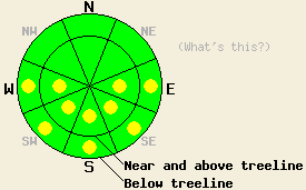
Early this morning, avalanche danger is LOW for all elevations and aspects. Some pockets of MODERATE avalanche danger will develop today on sun-exposed E-SE-S-SW-W aspects 37 degrees and steeper in response to daytime warming. |
|
|
|
High pressure continues to build over the forecast area in the wake of the weak weather system that exited that region yesterday morning. Sunny skies, above freezing air temperatures and moderate speed ridgetop winds are expected for today. Winds shifted from southwest to east yesterday evening and will continue through today. Remote sensors above 8,000' are reporting air temperatures in the upper teens and low 20s this morning.
Observations made yesterday on Mt. Judah (Donner Summit area) revealed that well developed melt freeze conditions existed on all aspects up to the summit at 8,300'. By 10:30am, the snow surface on S aspects below 7,600' was starting to become unsupportable. Snowpit data collected at 7,500' on a SE aspect 37 degree slope indicated that free water was present in the top two thirds of the seven foot deep snowpack. At the time of observations, melt water was percolating the top 14 inches of the snowpack with the leading edge of free water acting as a weak layer in layer bonding tests. Evidence of past free water from the mid February melt freeze cycle was evident in the lower third of the snowpack (pit profile). Full drainage of the snowpack was noted in nearby shallower areas where the overall snowpack was less than three feet deep.
Avalanche concerns:
Avalanche concerns for today continue to focus on warming instability. A solid overnight refreeze occurred last night creating widespread frozen snow surface conditions early this morning. As the day progresses, pockets of wet snow instability will form in sun exposed areas on E-SE-S-SW-W aspects. Once the top few inches of frozen snow surface melts, several feet of wet snow will exist in the upper portion of the snowpack in most sun exposed areas. Recent observations indicate that wet loose avalanche activity is the most likely form of instability today, however, a very isolated wet slab avalanche is not impossible.
Early this morning, avalanche danger is LOW for all elevations and aspects. Some pockets of MODERATE avalanche danger will develop today on sun-exposed E-SE-S-SW-W aspects 37 degrees and steeper in response to daytime warming.
| 0600 temperature: | 18 to 22 deg. F. |
| Max. temperature in the last 24 hours: | 44 to 47 deg. F. |
| Average wind direction during the last 24 hours: | southwest to east |
| Average wind speed during the last 24 hours: | 35 mph |
| Maximum wind gust in the last 24 hours: | 62 mph |
| New snowfall in the last 24 hours: | O inches |
| Total snow depth: | 79 to 119 inches |
For 7000-8000 ft: |
|||
| Tuesday: | Tuesday Night: | Wednesday: | |
| Weather: | Sunny skies. | Clear skies. | Sunny skies in the morning, becoming partly cloudy. |
| Temperatures: | 43 to 50 deg. F. | 19 to 26 deg. F. | 41 to 48 deg. F. |
| Wind direction: | E | E shifting to S | SW |
| Wind speed: | 10 to 20 mph with gusts to 30 mph. Winds decreasing to 5 to 15 mph. | Around 10 mph. | Around 10 mph in the morning increasing to 10 to 20 mph with gusts to 35 mph in the afternoon. |
| Expected snowfall: | O in. | O in. | O in. |
For 8000-9000 ft: |
|||
| Tuesday: | Tuesday Night: | Wednesday: | |
| Weather: | Sunny skies. | Clear skies. | Sunny skies in the morning, becoming partly cloudy. |
| Temperatures: | 38 to 45 deg. F. | 19 to 26 deg. F. | 36 to 43 deg. F. |
| Wind direction: | E | E shifting to S | SW |
| Wind speed: | 35 to 45 with gusts to 60 mph. WInds decreasing to 10 to 20 mph with gusts to 30 mph in the afternoon. | Around 10 mph. | Around 10 mph in the morning increasing to 15 to 25 mph with gusts to 45 mph in the afternoon. |
| Expected snowfall: | O in. | O in. | O in. |


This website is owned and maintained by the non-profit arm of the Sierra Avalanche Center. Some of the content is updated by the USDA avalanche forecasters including the forecasts and some observational data. The USDA is not responsible for any advertising, fund-raising events/information, or sponsorship information, or other content not related to the forecasts and the data pertaining to the forecasts.

