In partnership with: 
|
April 2, 2010 at 6:59 am |
|
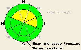
Near and above treeline MODERATE avalanche danger exists on the NW-N-NE-E aspects 35 degrees and steeper. Below treeline LOW avalanche danger exists. As another storm impacts the forecast area this afternoon and tonight, the avalanche danger will increase and could reach CONSIDERABLE on wind-loaded slopes near and above treeline during the night. |
|
|
|
Yesterday up to 3 inches of new snow fell on isolated parts of the forecast area as the last storm exited the region. Another low pressure system should start to move into the forecast area today. The southwest winds have already started to increase ahead of this system. The forecast calls for the winds to average between 45 and 60 mph with gusts to 100 mph by this afternoon. These winds should continue through tonight. This system should push some warmer air into the Sierra today before cooling back down into the teens overnight. Snow should start this afternoon and continue through the night bringing another 5-9 inches to the mountains above 7000'. By tomorrow this system should start to move eastward putting an end to the snow showers and causing the winds and cloud cover to decrease.
Snowpit data and observations from Stevens Peak (near Carson Pass) and Rubicon Peak (West Shore area) both showed that the upper snowpack continues to settle and gain strength. The weaknesses (graupel and some density changes) that formed during the storm have also gained strength and seem to be keeping up with the snow above them. Several inches of soft, light snow remained on the sheltered N-NE aspects in both of these areas yesterday. On the exposed N-NE aspects in these areas, stronger than forecasted winds started to form wind slabs near the ridgelines yesterday. On Rubicon Peak some minor cracking started to occur in the afternoon due to this new wind loading. On the E-SE-S-SW-W aspects in these areas a breakable sun crust existed on the snow surface.
Avalanche concerns: Wind Slabs
As the winds increase and start to transport more snow today, new winds slabs will continue to form even before snowfall starts this afternoon. Human triggered avalanches involving these new wind slabs will be possible. Most of these slabs should remain relatively small and isolated until it starts snowing today. Once the snow starts to fall, these slabs will quickly grow in size and become more widespread. As the snow and winds continue avalanche activity will become more likely. The most likely areas for avalanches will be on wind-loaded NW-N-NE-E aspects in near and above treeline terrain. However, instabilities could start to develop due to the strong winds and new snow on pockets of terrain at lower elevations by this evening. Careful snowpack observations can help determine where slabs have formed and where they have not. The best recreation and safest conditions will be on slopes where slabs have not formed and the snow remains soft and light.
Near and above treeline MODERATE avalanche danger exists on the NW-N-NE-E aspects 35 degrees and steeper. Below treeline LOW avalanche danger exists. As another storm impacts the forecast area this afternoon and tonight, the avalanche danger will increase and could reach CONSIDERABLE on wind-loaded slopes near and above treeline during the night.
| 0600 temperature: | 16 deg. F. |
| Max. temperature in the last 24 hours: | 23 deg. F. |
| Average wind direction during the last 24 hours: | Southwest |
| Average wind speed during the last 24 hours: | 25-30 mph |
| Maximum wind gust in the last 24 hours: | 62 mph |
| New snowfall in the last 24 hours: | 0-2 inches |
| Total snow depth: | 103-152 inches |
For 7000-8000 ft: |
|||
| Friday: | Friday Night: | Saturday: | |
| Weather: | Mostly cloudy with a chance of snow showers in the morning. Snow becoming more likely and more widespread this afternoon. | Snow | Cloudy with a slight chance (20%) of snow showers in the morning. Showers should taper off in the afternoon. |
| Temperatures: | 33-40 deg. F. | 16-23 deg. F. | 34-40 deg. F. |
| Wind direction: | Southwest | Southwest | Southwest |
| Wind speed: | 10-20 mph with gusts to 35 mph increasing to 25-35 mph with gusts to 60 mph in the afternoon | 20-35 mph with gusts to 60 mph | 10-20 mph with gusts to 40 mph decreasing to 30 mph in the afternoon |
| Expected snowfall: | up to 2 in. | 3-6 in. | trace in. |
For 8000-9000 ft: |
|||
| Friday: | Friday Night: | Saturday: | |
| Weather: | Mostly cloudy with a chance of snow showers in the morning. Snow becoming more likely and more widespread this afternoon. | Snow | Cloudy with a slight chance (20%) of snow showers in the morning. Showers should taper off in the afternoon. |
| Temperatures: | 29-36 deg. F. | 15-22 deg. F. | 27-35 deg. F. |
| Wind direction: | Southwest | Southwest | Southwest |
| Wind speed: | 20-30 mph with gusts to 85 mph increasing to 45-60 mph with gusts to 100 mph in the afternoon | 45-60 mph with gusts to 100 mph decreasing to 30-45 mph with gusts to 75 mph after midnight | 20-35 mph with gusts to 60 mph |
| Expected snowfall: | up to 2 in. | 4-7 in. | trace in. |


This website is owned and maintained by the non-profit arm of the Sierra Avalanche Center. Some of the content is updated by the USDA avalanche forecasters including the forecasts and some observational data. The USDA is not responsible for any advertising, fund-raising events/information, or sponsorship information, or other content not related to the forecasts and the data pertaining to the forecasts.

