In partnership with: 
|
April 9, 2010 at 6:57 am |
|
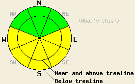
This morning the avalanche danger is LOW. The avalanche danger will increase to MODERATE at all elevations on E-SE-S-SW-W aspects 35 degrees and steeper due to daytime warming. |
|
|
|
The winds shifted back to the east and northeast last night. These east winds should continue today along with dry, sunny weather. By tonight, the winds should start to shift to the southwest, and clouds should start to build over the forecast area as a low pressure system approaches the region. The south and southwest winds should increase tomorrow due to this low pressure. By tomorrow afternoon some light snow showers could start to occur over the mountains.
Point-release avalanches, roller balls, and pin wheels continued to occur yesterday on Red Lake Peak near Carson Pass. Skiers triggered some of these wet surface instabilities and others occurred naturally. Most of yesterday's instabilities remained small. However, observers reported several larger point-release slides that most likely occurred on Tuesday or Wednesday on E-SE-S facing slopes on Echo Peak, Mt. Tallac, Maggie's Peak, and Jake's Peak. On Red Lake Peak below 9000', the snow on the sun-exposed, southerly slopes still has not gone through enough melt-freeze cycles to transition into good corn snow. Once the sun hits these slopes and melts the surface crusts, the snow becomes heavy, wet, and sticky at these elevations. On more-exposed, higher-elevation, E-SE-S facing slopes in the Red Lake Peak area where Tuesday night's strong east winds scoured away some of the recent snow, a more supportable snowpack with a few inches of soft, wet snow on the surface existed by noon yesterday. The sun even affected the more northerly aspects and created variable sun crusts on any surfaces that received any amount of sunshine. Some pockets of soft snow may still remain on the most shaded northerly aspects. Last night low temperatures in the low 20's and clear skies should have allowed the snowpack to undergo a solid refreeze.
Avalanche concerns: Warming instability
The solid overnight refreeze and light east to northeast winds will help keep the snowpack frozen for a little longer today. However, the intense April sunshine and daytime highs in the forties will still cause enough warming and melting in the snowpack to allow wet-snow instabilities to form on the sun-exposed E-SE-S-SW-W aspects. These instabilities should continue to grow less widespread as the snowpack undergoes more melt-freeze cycles. Roller balls, pinwheels, and point-release avalanches should comprise most of the instabilities today. Even though wet slab avalanches are unlikely today, they are not impossible. Avalanches large enough to bury or injure a person remain possible today.
This morning the avalanche danger is LOW. The avalanche danger will increase to MODERATE at all elevations on E-SE-S-SW-W aspects 35 degrees and steeper due to daytime warming.
| 0600 temperature: | 22 deg. F. |
| Max. temperature in the last 24 hours: | 41 deg. F. |
| Average wind direction during the last 24 hours: | Southwest shifting to the east northeast last night |
| Average wind speed during the last 24 hours: | Southwest: 25-30 mph | East northeast: 15 mph |
| Maximum wind gust in the last 24 hours: | 54 mph |
| New snowfall in the last 24 hours: | O inches |
| Total snow depth: | 107-154 inches |
For 7000-8000 ft: |
|||
| Friday: | Friday Night: | Saturday: | |
| Weather: | Sunny | Partly cloudy | Mostly cloudy with a 20% chance of snow showers in the afternoon. |
| Temperatures: | 45-50 deg. F. | 26-34 deg. F. | 41-46 deg. F. |
| Wind direction: | East | East | South |
| Wind speed: | 10 mph | 10-15 mph | 10 mph increasing to 15-25 mph with gusts to 35 mph in the afternoon |
| Expected snowfall: | O in. | O in. | up to 1 in. |
For 8000-9000 ft: |
|||
| Friday: | Friday Night: | Saturday: | |
| Weather: | Sunny | Partly cloudy | Mostly cloudy with a 20% chance of snow showers in the afternoon. |
| Temperatures: | 37-45 deg. F. | 24-29 deg. F. | 32-40 deg. F. |
| Wind direction: | East | East shifting to the southwest after midnight | South |
| Wind speed: | 10-20 mph with gusts to 30 mph | 10-15 mph with gusts to 30 mph | 10-15 mph with gusts to 30 mph increasing to 25-40 mph with gusts to 60 mph in the afternoon |
| Expected snowfall: | O in. | O in. | up to 1 in. |


This website is owned and maintained by the non-profit arm of the Sierra Avalanche Center. Some of the content is updated by the USDA avalanche forecasters including the forecasts and some observational data. The USDA is not responsible for any advertising, fund-raising events/information, or sponsorship information, or other content not related to the forecasts and the data pertaining to the forecasts.

