In partnership with: 
|
April 11, 2010 at 6:56 am |
|
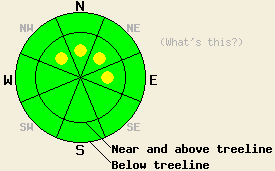
This morning, avalanche danger is LOW for all elevations and aspects. After the onset of snowfall, pockets of MODERATE danger will form near and above treeline on NW-N-NE-E aspects 35 degrees and steeper. Avalanche danger will likely to increase to CONSIDERABLE during the evening and overnight hours with natural avalanche activity possible. |
|
|
|
A significant storm system will move into the forecast area today. Light precipitation is expected to begin around mid day and continue through the afternoon hours. Snow level is expected to begin around 6,000' today and fall to 4,500' or lower as the storm progresses. High intensity snowfall is expected to begin around 5pm this evening and continue during the overnight hours. New snow amounts of 7 to 12 inches are expected over the next 24 hours. Ridgetop winds have remained moderate in speed out of the south to southwest over the past 24 hours. South to southwest ridgetop winds are expected to increase in speed today with gusts to 90 mph.
Observations made around the forecast area over the past few days have shown widespread melt freeze conditions in sun exposed areas on all aspects. Surface crusts of varying thickness exist in nearly all areas with the only exception being on northerly aspects above 8,000' that receive no direct sun whatsoever. With April sun angles equivalent to September sun angles, these areas are few and few between. Snowpit data collected yesterday on Silver Peak (Pole Creek area) in open near treeline terrain at 7,910' on a SE aspect 30 degrees slope revealed a well bonded snowpack in good condition to handle new snow loading (pit profile). This matches well with other recent observations from around the forecast area (more info).
Avalanche concerns: Storm snow
Avalanche concerns for most of the day today are few. Wet snow instability is not expected today. A small amount of snow surface melting will occur as air temperatures climb above freezing, especially below 8,000', but this is not expected to cause areas of instability. Once a few inches of new snow accumulate later today, pockets of instability are expected as small wind slabs form in wind loaded areas. This will mainly occur near and above treeline on NW-N-NE-E aspects and is not expected to become significant until the late afternoon or evening hours if the timing of snowfall today plays out as forecast.
This morning, avalanche danger is LOW for all elevations and aspects. After the onset of snowfall, pockets of MODERATE danger will form near and above treeline on NW-N-NE-E aspects 35 degrees and steeper. Avalanche danger will likely to increase to CONSIDERABLE during the evening and overnight hours with natural avalanche activity possible.
| 0600 temperature: | 26 to 31 deg. F. |
| Max. temperature in the last 24 hours: | 34 to 41 deg. F. |
| Average wind direction during the last 24 hours: | South southwest |
| Average wind speed during the last 24 hours: | 45 mph |
| Maximum wind gust in the last 24 hours: | 72 mph |
| New snowfall in the last 24 hours: | O inches |
| Total snow depth: | 104 to 151 inches |
For 7000-8000 ft: |
|||
| Sunday: | Sunday Night: | Monday: | |
| Weather: | Cloudy skies with scattered snow showers in the morning. Numerous snow showers in the afternoon. | Cloudy skies with snow. | Mostly cloudy to cloudy skies with snow showers likely. |
| Temperatures: | 33 to 40 deg. F. | 21 to 26 deg. F. | 27 to 34 deg. F. |
| Wind direction: | S | S | SW |
| Wind speed: | 20 to 35 mph with gusts 45 to 55 mph. | 20 to 35 mph with gusts to 60 mph. Gusts decreasing to 50 mph after midnight. | 15 to 25 mph with gusts to 40 mph. |
| Expected snowfall: | Up to 2 in. | 5 to 10 in. | 2 to 4 in. |
For 8000-9000 ft: |
|||
| Sunday: | Sunday Night: | Monday: | |
| Weather: | Cloudy skies with scattered snow showers in the morning. Numerous snow showers in the afternoon. | Cloudy skies with snow. | Mostly cloudy to cloudy skies with snow showers likely. |
| Temperatures: | 28 to 35 deg. F. | 14 to 21 deg. F. | 23 to 28 deg. F. |
| Wind direction: | S | S | SW |
| Wind speed: | 50 to 70 mph with gusts to 90 mph. | 50 to 70 mph with gusts to 90 mph. Winds decreasing to 40 to 55 mph with gusts to 70 mph after midnight. | 20 to 30 mph with gusts to 45 mph. |
| Expected snowfall: | Up to 2 in. | 5 to 10 in. | 2 to 5 in. |


This website is owned and maintained by the non-profit arm of the Sierra Avalanche Center. Some of the content is updated by the USDA avalanche forecasters including the forecasts and some observational data. The USDA is not responsible for any advertising, fund-raising events/information, or sponsorship information, or other content not related to the forecasts and the data pertaining to the forecasts.

