In partnership with: 
|
April 13, 2010 at 7:00 am |
|
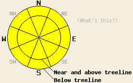
MODERATE avalanche danger exists on all aspects and at all elevations on slopes 35 degrees and steeper due to lingering wind slabs, poor bonding between the new snow and the crusts below it, and the formation of warming instabilities during the day today. If slopes receive more sunshine than forecasted the avalanche danger on sun-exposed southerly slopes may increase. |
|
|
|
Another 2-4 inches of snow fell in the mountains north of Hwy 50 in the last 24 hours. South of Hwy 50, 4-6 inches of new snow accumulated. The winds and cloud cover should start to decrease today as the storm moves east. Temperatures should also start to warm back up today and tomorrow with daytime highs climbing into the low to mid 40's at all elevations tomorrow. By tomorrow afternoon, more clouds and stronger southerly winds should return to the forecast area due to a low-pressure system north of the region.
Slab avalanches up to 2 ft in depth occurred on Hidden Peak (West Shore), Jake's Peak (West Shore), and on Elephant's Back (Carson Pass) on wind-loaded, N-NE facing, 35-40 degree slopes near and above treeline yesterday (for photos and more information see the observations page). Skiers and snowboarders triggered the slides on Hidden Peak and on Jake's Peak, and the interface between the new snow and the old crusts below it served as the weak layer. On Elephant's Back, the avalanche released naturally (most likely due to a natural cornice failure) and failed within the new snow. Shooting cracks also occurred in these areas in wind-affected, near and above treeline terrain. Below treeline in these areas, poor bonding existed between the new snow and the crusts below it; however, the light, new snow did not exhibit as many slab characteristics. Some soft slabs and several loose snow sluffs did occur in the below treeline terrain on slopes steeper than 35 degrees. Observations from Tamarack Peak in the Mt. Rose area showed much less new snow and generally less instability.
Avalanche Concern #1: Wind Slabs
The wind slabs that have formed on wind-loaded NW-N-NE-E aspects will remain the primary avalanche concern today. The largest and most tender of these slabs will exist on near and above treeline slopes. Large tender cornices will also exist above many of these slopes. Even though some settlement and consolidation in the new snow should make these wind slabs slightly more difficult to trigger today, human-triggered avalanches large enough to bury or injure a person involving these wind-slabs will remain possible.
Avalanche Concern #2: Warming Instabilities
Instabilities formed as the new snow starts to warm up today will comprise the second avalanche concern. The E-SE-S-SW-W aspects near and below treeline will hold the best potential for these types of instabilities. These instabilities will become larger and more widespread on any slopes that receive sunshine today. Most of these warming instabilities should take the form of point-release avalanches and other surface instabilities; however, some slab avalanches may be possible as well.
Avalanche Concern #3: Storm Snow
Below treeline, poor bonding between the new snow and the old crusts will continue to present a problem. Human-triggered sluffs and loose snow avalanches involving the new snow and running on the old crusts will remain possible today. Some soft slabs may also exist in open wind affected areas below treeline.
MODERATE avalanche danger exists on all aspects and at all elevations on slopes 35 degrees and steeper due to lingering wind slabs, poor bonding between the new snow and the crusts below it, and the formation of warming instabilities during the day today. If slopes receive more sunshine than forecasted the avalanche danger on sun-exposed southerly slopes may increase.
| 0600 temperature: | 21 deg. F. |
| Max. temperature in the last 24 hours: | 26 deg. F. |
| Average wind direction during the last 24 hours: | Southwest |
| Average wind speed during the last 24 hours: | 25-35 mph |
| Maximum wind gust in the last 24 hours: | 72 mph |
| New snowfall in the last 24 hours: | North of Hwy 50: 2-4 inches | South of Hwy 50: 4-6 inches |
| Total snow depth: | 110-160 inches |
For 7000-8000 ft: |
|||
| Tuesday: | Tuesday Night: | Wednesday: | |
| Weather: | Mostly cloudy with some isolated snow showers | Mostly cloudy in the evening becoming partly cloudy | Partly cloudy in the morning becoming mostly cloudy in the afternoon |
| Temperatures: | 33-40 deg. F. | 20-27 deg. F. | 39-47 deg. F. |
| Wind direction: | Southwest | Southwest shifting to the south | South |
| Wind speed: | 10 mph | 10 mph | 10-15 mph with gusts to 30 mph |
| Expected snowfall: | O in. | O in. | O in. |
For 8000-9000 ft: |
|||
| Tuesday: | Tuesday Night: | Wednesday: | |
| Weather: | Mostly cloudy with some isolated snow showers | Mostly cloudy in the evening becoming partly cloudy | Partly cloudy in the morning becoming mostly cloudy in the afternoon |
| Temperatures: | 25-35 deg. F. | 17-25 deg. F. | 32-39 deg. F. |
| Wind direction: | Southwest | South | South |
| Wind speed: | 10-15 mph | 10 mph | 10-20 mph with gusts to 35 mph |
| Expected snowfall: | O in. | O in. | O in. |


This website is owned and maintained by the non-profit arm of the Sierra Avalanche Center. Some of the content is updated by the USDA avalanche forecasters including the forecasts and some observational data. The USDA is not responsible for any advertising, fund-raising events/information, or sponsorship information, or other content not related to the forecasts and the data pertaining to the forecasts.

