In partnership with: 
|
April 15, 2010 at 6:49 am |
|
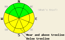
MODERATE avalanche danger will form on E-SE-S-SW-W aspects at all elevations on slopes 35 degrees and steeper due to daytime warming. |
|
|
|
A high pressure over the forecast area today will bring warmer temperatures, clearer skies, and a light southerly wind to the area. Today's daytime highs should reach 10 degrees higher than yesterday's and push up into the upper 40's even above 8000'. Another weak disturbance due to the low pressure north and west of the area should pass through the region tomorrow afternoon. Increased southwest winds, some cloud cover, and slightly cooler temperatures will be the main effects of this disturbance.
Shallow, cold, soft snow remained on the north aspects of Incline Lake Peak above 8600' yesterday. On the more sun-exposed E-SE-S aspects, 1-3 inches of soft, wet snow existed on top of a firm and supportable melt-freeze crust. Since much less snow fell in this area during the last storm, the recent snow on these aspects is much closer to becoming good corn snow than the snow along the crest. Hand pits and ski cuts on test slopes showed good bonding between the recent snow and the snow below it on all aspects in this area yesterday. A few small roller balls did occur near SE-S facing cliffs; however, these did not entrain enough snow to pose much of a threat to backcountry travelers. Overnight lows in the 20's and clear skies should have allowed the snowpack to undergo a solid overnight refreeze.
Avalanche Concern #1: Warming Instabilities
Wet-snow instabilities that form due to daytime warming will again comprise the primary avalanche concern today. The intense April sunshine, lack of significant cloud cover, and daytime highs in the 40's and even low 50's will all work to make these instabilities more widespread today. The E-SE-S-SW-W aspects will hold the best potential for these types of instabilities. However, wet-snow instabilities could form on any slopes that receive significant sunshine including some of the more northerly aspects. Most of these warming instabilities should take the form of point-release avalanches and other surface instabilities; however, some wet-slab avalanches may be possible in isolated areas as well.
MODERATE avalanche danger will form on E-SE-S-SW-W aspects at all elevations on slopes 35 degrees and steeper due to daytime warming.
| 0600 temperature: | 23-28 deg. F. |
| Max. temperature in the last 24 hours: | 29-39 deg. F. |
| Average wind direction during the last 24 hours: | South southwest |
| Average wind speed during the last 24 hours: | 35 mph |
| Maximum wind gust in the last 24 hours: | 78 mph |
| New snowfall in the last 24 hours: | O inches |
| Total snow depth: | 106-155 inches |
For 7000-8000 ft: |
|||
| Thursday: | Thursday Night: | Friday: | |
| Weather: | Partly cloudy | Partly cloudy becoming mostly cloudy after midnight | Mostly cloudy with a slight chance of showers |
| Temperatures: | 45-52 deg. F. | 25-35 deg. F. | 42-49 deg. F. |
| Wind direction: | South | Southwest | Southwest |
| Wind speed: | 10 mph | 10 mph | 10-15 mph |
| Expected snowfall: | O in. | O in. | O in. |
For 8000-9000 ft: |
|||
| Thursday: | Thursday Night: | Friday: | |
| Weather: | Partly cloudy | Partly cloudy becoming mostly cloudy after midnight | Mostly cloudy with a slight chance of snow showers |
| Temperatures: | 38-48 deg. F. | 30-38 deg. F. | 34-43 deg. F. |
| Wind direction: | South | South | South shifting to the southwest |
| Wind speed: | 10-15 mph with gusts to 25 mph | 10-15 mph | 10 mph increasing to 15-25 mph with gusts to 35 mph |
| Expected snowfall: | O in. | O in. | O in. |


This website is owned and maintained by the non-profit arm of the Sierra Avalanche Center. Some of the content is updated by the USDA avalanche forecasters including the forecasts and some observational data. The USDA is not responsible for any advertising, fund-raising events/information, or sponsorship information, or other content not related to the forecasts and the data pertaining to the forecasts.

