In partnership with: 
|
April 16, 2010 at 6:43 am |
|
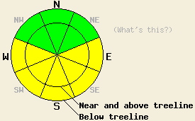
Avalanche danger is MODERATE on E-SE-S-SW-W aspects at all elevations on slopes 35 degrees and steeper due to warming instability and poor overnight refreeze. Very, very isolated pockets of instability linger on northerly aspects. Normal caution is advised. |
|
|
|
A weak weather system will pass to the north of the forecast area today. Most locations will see partly to mostly cloudy skies today. A few brief showers with no significant precipitation may occur in isolated areas. Increasing cloud cover over the forecast area late yesterday and overnight has kept air temperatures warm with above freezing air temperatures in all areas below 8,000'. Above 8,000', air temperatures are above freezing in some locations and just below freezing in other locations. Air temperatures are expected to warm into the upper 30s to upper 40s in most locations today. Ridgetop winds shifted from south to southwest yesterday morning and have remain light to moderate in speed. Winds are forecast to remain light to moderate in speed out of the southwest into tomorrow.
Observations made yesterday on Red Lake Peak (Carson Pass area) revealed melt freeze conditions on all E-SE-S aspects traveled above treeline between 8,000' and 9,600'. A good snow surface refreeze occurred in this area Wednesday night. At 11:45 am yesterday, unsupportable wet snow over cold recent storm snow existed on E aspects that had been wind loaded during the last storm. Supportable melt freeze conditions existed on SE-S aspects that had been more wind scoured during that last storm. Near Frog Lake (Carson Pass area), snowpit data collected near treeline at 8,830' on a N aspect 40 degree slope revealed very isolated pockets of hard slab instability. The weak layer existed around 10 inches below the snow surface where a higher density slab sat on top of lower density recent storm snow. Fracture propagation tests produced very repeatable failures and indicated that fracture propagation was likely in this area (pit profile, video). Ski cuts performed on other portions of the same slope and on adjacent slopes produced no further evidence of instability.
Avalanche Concern #1: Warming Instability
Cloud cover over the forecast area last night is expected to have greatly inhibited snow surface refreeze. A weak refreeze is expected to have occurred above 8,000' to 9,000'. A very weak refreeze and possibly no overnight refreeze is likely in areas below 8,000'. This will allow for the possibility of human triggered wet loose and possibly wet slab avalanches to occur throughout the day, beginning during the early morning hours. Any wet slab avalanche activity could be large enough to bury or injure a person.
Avalanche Concern #2: Hard slabs
Very, very isolated pockets of hard slab instability linger on northerly aspects. These unstable slabs were noted yesterday to exist in areas where a supportable high density wind crust sits on top of lower density recent storm snow. These slabs will be difficult to trigger today, but may have significant destructive potential due to the hardness of the slab. These pockets of instability will exist within larger areas of stable snow. Due to the nature of hard slab instabilities, an avalanche may occur after several people have traveled the slope and not until a person is well out onto the slope, increasing the likelihood of burial.
Avalanche danger is MODERATE on E-SE-S-SW-W aspects at all elevations on slopes 35 degrees and steeper due to warming instability and poor overnight refreeze. Very, very isolated pockets of instability linger on northerly aspects. Normal caution is advised.
| 0600 temperature: | 30 to 36 deg. F. |
| Max. temperature in the last 24 hours: | 46 to 50 deg. F. |
| Average wind direction during the last 24 hours: | South shifting to southwest |
| Average wind speed during the last 24 hours: | 20 mph |
| Maximum wind gust in the last 24 hours: | 49 mph |
| New snowfall in the last 24 hours: | O inches |
| Total snow depth: | 104 to 153 inches |
For 7000-8000 ft: |
|||
| Friday: | Friday Night: | Saturday: | |
| Weather: | Mostly cloudy skies in the morning, becoming partly cloudy. | Partly cloudy skies in the evening, then clearing. | Sunny skies in the morning becoming partly cloudy. |
| Temperatures: | 43 to 50 deg. F. | 23 to 30 deg. F. | 47 to 54 deg. F. |
| Wind direction: | SW | SW | S shifting to SW |
| Wind speed: | 10 to 15 mph with gusts up to 25 mph in the afternoon. | 10 to 15 mph with gusts to 25 mph in the evening. | Up to 10 mph. |
| Expected snowfall: | O in. | O in. | O in. |
For 8000-9000 ft: |
|||
| Friday: | Friday Night: | Saturday: | |
| Weather: | Mostly cloudy skies in the morning, becoming partly cloudy. | Partly cloudy skies in the evening, then clearing. | Sunny skies in the morning becoming partly cloudy. |
| Temperatures: | 38 to 45 deg. F. | 25 to 32 deg. F. | 43 to 50 deg. F. |
| Wind direction: | SW | SW | SW |
| Wind speed: | 10 to 20 mph with gusts to 30 mph. Winds increasing to 15 to 25 mph with gusts to 40 mph in the aftenoon. | 15 to 25 mph with gusts to 40 mph. Winds decresing to 10 to 15 mph with gusts to 25 mph after midnight. | 10 to 15 mph with gusts to 25 mph. |
| Expected snowfall: | O in. | O in. | O in. |


This website is owned and maintained by the non-profit arm of the Sierra Avalanche Center. Some of the content is updated by the USDA avalanche forecasters including the forecasts and some observational data. The USDA is not responsible for any advertising, fund-raising events/information, or sponsorship information, or other content not related to the forecasts and the data pertaining to the forecasts.

