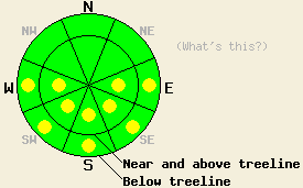
This Avalanche Advisory was published on April 17, 2010:

|
April 17, 2010 at 6:45 am |
|
Early this morning, avalanche danger is LOW for all elevations and aspects. Pockets of MODERATE danger will form at all elevations on E-SE-S-SW-W aspects in response to daytime warming. Very isolated areas of instability may exist on northerly aspects. Normal caution is advised. |
|
|
|
Forecast Discussion:
High pressure is building over the forecast area. Cloud cover decreased overnight and will allow for plenty of sunshine today. A weak air temperature inversion is in place this morning with the coldest air below 7,000'. Remote sensors are reporting air temperatures above 8,000' in the upper 20s to mid 30s this morning. Air temperatures are expected to rise into the mid 40s to low 50s above 7,000'. Ridgetop winds have remained light to moderate in speed out of the southwest for the past 48 hours and are expected to continue through tonight.
Observations made yesterday on Silver Peak (Pole Creek area) revealed melt freeze conditions on all aspects up to the summit at 8,300'. Areas below 7,400' showed evidence of very weak or no overnight refreeze. Better than expected overnight refreeze occurred above 7,800' with supportable corn conditions on SE aspects at 11:45 am. Test pits dug near treeline at 8,000' on a N aspect 35 degree slope and above treeline at 8,200' on a N aspect 30 degree slope found no evidence instability. Observations made on Round Top Peak (Carson Pass area) indicated that melt freeze conditions were less widespread at higher elevations with cold, dry snow and slight wind effect on N-NE aspects above 9,000ft. Cloud cover and locally moderate to strong SW winds prevented the snow surface on exposed E-SE aspects from melting. In some areas, sheltered E-SE aspects showed evidence of having undergone only a very weak overnight refreeze with a soft breakable surface crust. No signs of instability were observed and no additional pockets of the hard slab instability observed in the area on Thursday (more info) were discovered.
Avalanche Concern #1: Warming Instability
Decreasing cloud cover and near to below freezing air temperatures are expected to have allowed for a decent refreeze of wet surface snow last night due to radiational cooling. In many areas, the snowpack has undergone enough transformation since the last storm that more supportable melt freeze conditions will exist, allowing for good recreation during the late morning hours. As the day progresses, pockets of wet snow instability will become increasingly widespread in steep terrain mainly on E-SE-S-SW-W aspects and possibly in isolated sun exposed areas on mid and lower elevation NW-N-NE aspects. Once enough melting occurs that the snow surface is no longer supportable, the transition to unstable conditions can occur very rapidly.
Avalanche Concern #2: Hard slabs
Very, very isolated pockets of hard slab instability linger in near and above treeline terrain on northerly aspects above 8,500'. This instability was noted Thursday in the Carson Pass area and may exist in other areas where a supportable high density wind affected surface slab sits on top of lower density recent storm snow. These pockets of instability will exist within larger areas of stable snow. Due to the nature of hard slab instabilities, an avalanche may occur after several people have traveled the slope and not until a person is well out onto the slope, increasing the likelihood of burial.
The bottom line:
Early this morning, avalanche danger is LOW for all elevations and aspects. Pockets of MODERATE danger will form at all elevations on E-SE-S-SW-W aspects in response to daytime warming. Very isolated areas of instability may exist on northerly aspects. Normal caution is advised.
Weather Observations from along the Sierra Crest between 8200 ft and 8800 ft:
| 0600 temperature: | 28 to 36 deg. F. |
| Max. temperature in the last 24 hours: | 38 to 45 deg. F. |
| Average wind direction during the last 24 hours: | Southwest |
| Average wind speed during the last 24 hours: | 25 mph |
| Maximum wind gust in the last 24 hours: | 46 mph |
| New snowfall in the last 24 hours: | O inches |
| Total snow depth: | 101 to 150 inches |
Two-Day Mountain Weather Forecast - Produced in partnership with the Reno NWS
For 7000-8000 ft: |
|||
| Saturday: | Saturday Night: | Sunday: | |
| Weather: | Sunny skies. | Partly cloudy skies. | Partly cloudy skies in the morning then clearing. |
| Temperatures: | 45 to 52 deg. F. | 29 to 34 deg. F. | 49 to 56 deg. F. |
| Wind direction: | SW | SW | S |
| Wind speed: | Up to 10 mph. | 10 to 15 mph in the evening becoming light. | Light winds around 10 mph in the afternoon. |
| Expected snowfall: | O in. | O in. | O in. |
For 8000-9000 ft: |
|||
| Saturday: | Saturday Night: | Sunday: | |
| Weather: | Sunny skies. | Partly cloudy skies. | Partly cloudy skies in the morning then clearing. |
| Temperatures: | 41 to 48 deg. F. | 30 to 36 deg. F. | 44 to 51 deg. F. |
| Wind direction: | SW | SW | S |
| Wind speed: | 10 to 20 mph with gusts to 30 mph. | 10 to 15 mph with gusts up to 30 mph in the evening. | 10 to 15 mph with gusts up to 25 mph in the afternoon. |
| Expected snowfall: | O in. | O in. | O in. |


