In partnership with: 
|
April 19, 2010 at 6:15 am |
|
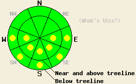
Early this morning, the avalanche danger is LOW for all elevations and aspects. As the sun hits the snow and the day warms up, pockets of MODERATE danger will quickly form on the E-SE-S-SW-W aspects 35 degrees and steeper at all elevations. |
|
|
|
The high pressure over the forecast area should bring one more day of warm weather to the region today. The forecast calls for daytime highs just a few degrees cooler than yesterday. A strong, cold, spring storm should start to replace this high pressure later this afternoon. The winds and cloud cover should start to increase, and temperatures should start to fall this evening. By tonight snow should start to fall across the forecast area. The forecast calls for this storm to intensify during the day on Tuesday and for several inches of accumulation in the Sierra. For more information see the Reno NWS website.
Yesterday, 2-4 inches of soft, wet, corn snow existed on top of a supportable melt-freeze crust on the E-SE-S facing aspects up to 10,000' on Relay Peak in the Mt. Rose backcountry by 11am. A firm melt-freeze crust existed on the more NE facing slopes up to 9800'. The due N facing aspects between 9000' and 10,000' still had cold, dry wind-buffed snow on the surface. Below 9000' a firm melt-freeze crust existed most northerly aspects, and 2-3 inches of sticky, wet snow existed in any areas that had sun-exposure. Ski-cuts, ski pole probes, and quick hand pits all indicated a snowpack that should be able to support this week's new snow load.
Avalanche Concerns:
Another day with some intense April sunshine and daytime highs that make people want to trade boots for flip-flops will again melt the bonds holding the snowpack together. As these bonds melt, the snow will weaken and wet-snow instabilities may form. Overnight lows above freezing and hot days have shortened the time available for the snowpack to gain strength by refreezing during the last 2 days. The melting and weakening of the snowpack should occur quickly again today due to these weaker, shorter refreezes. As the clouds and winds increase and the temperatures decrease this evening, the snowpack should start refreeze. If these changes in the weather happen earlier in the day, wet-snow instabilities should be less widespread. Wet-snow instabilities should be most prevalent on E-SE-S-SW-W aspects; however, mid and lower elevation NW-N-NE aspects may hold pockets of these types of instabilities as well. Clues like pinwheels, roller-balls, and sinking into wet snow above your boot tops can help determine which slopes have warmed up enough for significant wet-snow instabilities to form.
Early this morning, the avalanche danger is LOW for all elevations and aspects. As the sun hits the snow and the day warms up, pockets of MODERATE danger will quickly form on the E-SE-S-SW-W aspects 35 degrees and steeper at all elevations.
| 0600 temperature: | 35-38 deg. F. |
| Max. temperature in the last 24 hours: | 53-58 deg. F. |
| Average wind direction during the last 24 hours: | Variable shifting to southwest after 4 pm yesterday |
| Average wind speed during the last 24 hours: | Before 4pm yesterday: 5-10 mph | After 4 pm yesterday: 20 mph |
| Maximum wind gust in the last 24 hours: | 32 mph |
| New snowfall in the last 24 hours: | O inches |
| Total snow depth: | 98-147 inches |
For 7000-8000 ft: |
|||
| Monday: | Monday Night: | Tuesday: | |
| Weather: | Partly cloudy becoming mostly cloudy later in the day. | Cloudy chance of snow after midnight. | Snow |
| Temperatures: | 49-56 deg. F. | 28-35 deg. F. | 30-37 deg. F. |
| Wind direction: | South | Southwest | Southwest |
| Wind speed: | 10-15 mph increasing to 15-25 mph with gusts to 45 mph in the afternoon | 20-30 mph with gusts to 50 mph | 20-30 mph gusts to 50 mph |
| Expected snowfall: | O in. | up to 1 in. | 2-6 in. |
For 8000-9000 ft: |
|||
| Monday: | Monday Night: | Tuesday: | |
| Weather: | Partly cloudy becoming mostly cloudy later in the day. | Cloudy chance of snow after midnight. | Snow |
| Temperatures: | 48-54 deg. F. | 24-31 deg. F. | 26-33 deg. F. |
| Wind direction: | South | South shifting to the southwest | Southwest |
| Wind speed: | 10-20 mph with gusts to 35 mph increasing to 25-35 mph with gusts to 60 mph in the afternoon | 30-45 mph with gusts to 70 mph increasing to 35-55 mph with gusts to 85 mph after midnight | 30-40 mph with gusts to 75 mph decreasing to 20-30 mph with gusts to 45 mph in the afternoon |
| Expected snowfall: | O in. | up to 1 in. | 4-7 in. |


This website is owned and maintained by the non-profit arm of the Sierra Avalanche Center. Some of the content is updated by the USDA avalanche forecasters including the forecasts and some observational data. The USDA is not responsible for any advertising, fund-raising events/information, or sponsorship information, or other content not related to the forecasts and the data pertaining to the forecasts.

