In partnership with: 
|
April 24, 2010 at 7:00 am |
|
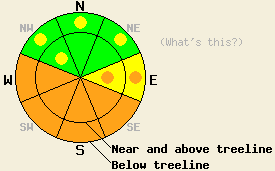
The avalanche danger will rise to CONSIDERABLE again today on the sun-exposed SE-S-SW-W aspects steeper than 35 degrees due to daytime warming. Pockets of CONSIDERABLE danger may also form on E aspects. On the cross-loaded NW aspects near and above treeline and the NW-N-NE aspects below treeline pockets of MODERATE avalanche danger exist. |
|
|
|
The high pressure ridge over the region should keep the weather sunny and warm again today. Daytime highs should climb back into the mid 40's to low to 50's at all elevations above 7000'. The winds should increase some during the day today due to a small low pressure system north of the forecast area. By tomorrow, these winds should calm back down.
Numerous avalanches occurred yesterday due to daytime warming. On Castle Peak (near Donner Pass), point release avalanches started to move by 10:30 am on southerly aspects up to 8700'. Snowpit observations on a SE aspect on Castle Peak showed that the recent snow has not had time to develop drainage channels for the melt-water to flow through. Wind-loading by the recent NE winds had created wind slabs 1-2 ft deep on these aspects as well. One natural wet-slab avalanche about 100 ft. wide was reported on a steep, SE aspect on Mt. Tallac around 1:30 pm. This slide started at about 9000', and debris from this slide extended for about 1000 ft. downhill. Ski cuts on steep test slopes triggered large roller balls and pinwheels on the low to mid elevation northerly aspects on Castle Peak and on Talking Mt. ( near Echo Summit). Observations showed a thin, breakable crust on the sheltered northerly aspects up to 8600'. On the more exposed northerly aspects, the recent NE winds left the old, hard snow surface exposed in many places. As soon as the sun hit the snow surface on most aspects, the snow became wet, heavy, and sticky yesterday. Remote sensors show that overnight temperatures did not drop below freezing even at the highest elevations in most areas making last night's refreeze weak at best.
Avalanche Concern #1: Wet snow instabilities
Daytime highs in the mid 40's to low 50's at all elevations, intense sunshine, a weak overnight refreeze, and new snow without good drainage channels through it will make wet snow instabilities the main avalanche concern today. Until those drainage channels develop in the new snow, melt water caused by the intense sunshine and warm air temperatures will pool in the recent snow and weaken the bonds holding the snow in place. Enough melting and weakening could easily occur for human-triggered and natural wet snow avalanches to happen today. Point-release avalanche should comprise most of these avalanches; however, some wet slab avalanches could also occur today as the snowpack warms up. The sun-exposed W-SW-S-SE-E aspects will hold the best potential for these wet snow instabilities; however, pockets of warming instabilities could also exist on the low to mid elevation northerly aspects. These slides could be large enough to bury or injure a person.
The avalanche danger will rise to CONSIDERABLE again today on the sun-exposed SE-S-SW-W aspects steeper than 35 degrees due to daytime warming. Pockets of CONSIDERABLE danger may also form on E aspects. On the cross-loaded NW aspects near and above treeline and the NW-N-NE aspects below treeline pockets of MODERATE avalanche danger exist.
| 0600 temperature: | 32-37 deg. F. |
| Max. temperature in the last 24 hours: | 45-51 deg. F. |
| Average wind direction during the last 24 hours: | Northeast until midday yesterday becoming variable after that |
| Average wind speed during the last 24 hours: | Northeast: 15-20 mph | Variable: 5-10 mph |
| Maximum wind gust in the last 24 hours: | 46 mph |
| New snowfall in the last 24 hours: | O inches |
| Total snow depth: | 90-143 inches |
For 7000-8000 ft: |
|||
| Saturday: | Saturday Night: | Sunday: | |
| Weather: | Sunny | Clear in the evening becoming partly cloudy after midnight | Sunny with a few clouds developing in the afternoon |
| Temperatures: | 49-56 deg. F. | 28-36 deg. F. | 49-56 deg. F. |
| Wind direction: | East shifting to the West | West | Variable |
| Wind speed: | 10-20 mph with gusts to 30 mph | 10-15 mph with gusts to 30 mph decreasing after midnight | Light |
| Expected snowfall: | O in. | O in. | O in. |
For 8000-9000 ft: |
|||
| Saturday: | Saturday Night: | Sunday: | |
| Weather: | Sunny | Clear in the evening becoming partly cloudy after midnight | Sunny with a few clouds developing in the afternoon |
| Temperatures: | 46-52 deg. F. | 26-33 deg. F. | 48-54 deg. F. |
| Wind direction: | East shifting to the West | West shifting to the northwest | South |
| Wind speed: | 10-15 mph increasing to 15-20 mph with gusts to 45 mph | 10-20 mph with gusts to 45 mph | up to 10 mph |
| Expected snowfall: | O in. | O in. | O in. |


This website is owned and maintained by the non-profit arm of the Sierra Avalanche Center. Some of the content is updated by the USDA avalanche forecasters including the forecasts and some observational data. The USDA is not responsible for any advertising, fund-raising events/information, or sponsorship information, or other content not related to the forecasts and the data pertaining to the forecasts.

