In partnership with: 
|
November 21, 2010 at 7:55 am |
|
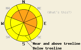
Near and above treeline, avalanche danger is CONSIDERABLE danger on NW-N-NE-E-SE aspects, 35 degrees and steeper. Below treeline, avalanche danger is MODERATE in open wind affected areas, 35 degrees and steeper. |
|
|
|
Another high intensity snowfall event occurred last night. New snow amounts for the past 24 hours are 14 to 21 inches along the Sierra Crest and 9 to 15 inches along the Carson Range. This brings storm totals since Friday afternoon up to 15 to 39 inches. Another 5 to 10 inches of additional accumulation is expected to occur above 7,000' today. Ridgetop winds remain moderate to strong out of the southwest this morning and are forecast to continue into tomorrow. Data from remote ridgetop wind speed sensors for the last 24 hours appears in error, so assumptions have been made based on yesterday's field observations and the wind speed forecast. Air temperatures at 8,000' are in the mid teens this morning and are expected to remain in the mid teens throughout the day.
Observations were made yesterday on Lincoln Ridge (Yuba Pass area), Andesite Ridge (Donner Summit area), and Elephant's Back (Carson Pass area). Observations from all three of these areas indicated good bonding at the old/new snow interface and minimal instabilities within the storm snow in wind protected areas. In wind affected areas, minor cracking and significant wind loading was observed, indicating a likely presence of unstable slabs in wind loaded avalanche start zones. For snowpit profiles and photos click here. No signs of natural or human triggered avalanches were observed, however visibility of surrounding terrain was generally poor.
Avalanche Concerns:
Avalanche concerns for today continue to focus on the new snow. The best window for natural avalanche activity associated with this storm cycle occurred last night. However, with continued snowfall and wind transport today, natural avalanches remain possible. Human triggered avalanches are likely in wind loaded areas. Snowpack failure that occurs today is expected to occur within the storm snow in wind affected areas. The areas of greatest concern for slab avalanches are near and above treeline on wind loaded NW-N-NE-E-SE aspects. Concern for unstable slabs also exist below treeline in open wind affected areas on all aspects.
Near and above treeline, avalanche danger is CONSIDERABLE danger on NW-N-NE-E-SE aspects, 35 degrees and steeper. Below treeline, avalanche danger is MODERATE in open wind affected areas, 35 degrees and steeper.
| 0600 temperature: | 14 to 16 deg. F. |
| Max. temperature in the last 24 hours: | 20 to 22 deg. F. |
| Average wind direction during the last 24 hours: | Southwest |
| Average wind speed during the last 24 hours: | estimated at 37 mph |
| Maximum wind gust in the last 24 hours: | estimated at 65 mph |
| New snowfall in the last 24 hours: | 9 to 21 inches |
| Total snow depth: | 15 to 45 inches |
For 7000-8000 ft: |
|||
| Sunday: | Sunday Night: | Monday: | |
| Weather: | Cloudy skies with snow showers. | Cloudy skies with snow. | Cloudy skies with snow showers. |
| Temperatures: | 13 to 20 deg. F. | 10 to 17 deg. F. | 16 to 23 deg. F. |
| Wind direction: | SW | SW | SW |
| Wind speed: | 15 to 25 mph with gusts to 40 mph. | 10 to 20 mph with gusts to 30 mph. | 15 to 25 mph with gusts to 35 mph. |
| Expected snowfall: | 5 to 10 in. | 4 to 8 in. | Up to 3 in. |
For 8000-9000 ft: |
|||
| Sunday: | Sunday Night: | Monday: | |
| Weather: | Cloudy skies with snow showers. | Cloudy skies with snow. | Cloudy skies with snow showers. |
| Temperatures: | 12 to 18 deg. F. | 6 to 13 deg. F. | 12 to 19 deg. F. |
| Wind direction: | SW | SW | SW |
| Wind speed: | 25 to 35 mph with gusts to 60 mph. | 25 to 35 mph with gusts to 50 | 25 to 40 mph with gusts to 60 mph. |
| Expected snowfall: | 5 to 10 in. | 4 to 8 in. | Up to 4 in. |


This website is owned and maintained by the non-profit arm of the Sierra Avalanche Center. Some of the content is updated by the USDA avalanche forecasters including the forecasts and some observational data. The USDA is not responsible for any advertising, fund-raising events/information, or sponsorship information, or other content not related to the forecasts and the data pertaining to the forecasts.

