In partnership with: 
|
November 23, 2010 at 7:59 am |
|
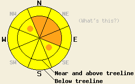
Near and above treeline on slopes steeper than 35 degrees, CONSIDERABLE avalanche danger exists on N-NE-E aspects with pockets of CONSIDERABLE danger on the NW and SE aspects. On all other aspects above treeline and on all aspects below treeline, the avalanche danger is MODERATE. The most likely time for natural avalanches and easily human-triggered avalanches will be during the period of intense snowfall and strong winds forecasted to occur through midday today. |
|
|
|
A strong, fast-moving, very cold front should move through the forecast area today. As the edge of this front reaches the region this morning, snowfall rates and winds should rapidly increase and remain intense for a few hours. The forecast calls for snowfall rates of 3 inches per hour and sustained winds of 50-60 mph with gusts to 100 mph above treeline. By this afternoon snowfall, winds, and temperatures should start to decrease as the edge of the cold front moves rapidly south and east. Tonight skies should start to clear and the winds should begin shifting to the east and northeast and decrease even more. The cold front will leave behind a mass of cold air that could push low temperatures near zero for the next few nights. Expect a cold but sunny day during the day tomorrow with daytime highs only reaching into the upper teens in the mountains. The valleys may be even colder due to a temperature inversion.
Observations on Powderhouse Peak (Luther Pass area), on Silver Peak (Pole Creek drainage), and on Tamarack Peak (Mt. Rose backcountry) all showed significant settlement in the recent snow. Even with this settlement this snow remains unconsolidated and soft making for some strenuous trail breaking. Snowpits and layer bonding tests in these areas all indicated that the existing snow had also gained some strength. Ski cutting wind-loaded and non-wind-loaded test slopes in these areas did not result in any avalanche activity. Some very small and isolated cracking did occur on the most wind-affected test slopes in the Mt. Rose area and on Silver Peak. Near and above treeline in these areas, observers also reported wind slabs that were more supportable than the non-wind-affected snow. Overnight remote sensors have reported continued southwest winds strong enough to transport snow and an additional 4-12 in. of new snow.
Avalanche Concern #1: Wind Slabs
Intense snowfall of 3 inches per hour and increased winds this morning will combine to create new wind slabs on the wind-loaded aspects today. These wind slabs could become more than 3 ft. thick in just a few hours. These wind slabs will form on top of previous wind slabs and soft unconsolidated snow. This rapid loading and slab formation will make natural avalanches possible today and human-triggered avalanches likely. These wind slabs will be most prevalent on the NW-N-NE-E-SE aspects near and above treeline, but they could also form on any wind-affected slope. These wind slabs will be the most sensitive to failing during the period of high intensity snowfall and winds this morning. If the intense snowfall continues longer than forecasted, these slabs will become even larger and more fragile.
Avalanche Concern #2: Storm Snow
Even in non-wind-loaded areas the intense snowfall will load the current snowpack so quickly that it may have trouble supporting this new load. During the intense snowfall this morning, the additional weight of a skier, boarder, or snowmobiler may be enough to trigger soft slab avalanches on any slope steeper than 35 degrees. Like the wind slabs, these soft slabs will be most fragile during the the period of high intensity snowfall this morning. If the intense snowfall continues longer than forecasted these slabs will become larger and more fragile.
Near and above treeline on slopes steeper than 35 degrees, CONSIDERABLE avalanche danger exists on N-NE-E aspects with pockets of CONSIDERABLE danger on the NW and SE aspects. On all other aspects above treeline and on all aspects below treeline, the avalanche danger is MODERATE. The most likely time for natural avalanches and easily human-triggered avalanches will be during the period of intense snowfall and strong winds forecasted to occur through midday today.
| 0600 temperature: | 18 deg. F. |
| Max. temperature in the last 24 hours: | 21 deg. F. |
| Average wind direction during the last 24 hours: | Southwest |
| Average wind speed during the last 24 hours: | 25 mph |
| Maximum wind gust in the last 24 hours: | 46 mph |
| New snowfall in the last 24 hours: | 4-12 inches |
| Total snow depth: | 34-66 inches |
For 7000-8000 ft: |
|||
| Tuesday: | Tuesday Night: | Wednesday: | |
| Weather: | Heavy snow with snowfall rates up to 3 in./hr in the morning decreasing to showers in the afternoon | Partly cloudy with isolated snow showers before midnight. Becoming clear after midnight. | Sunny |
| Temperatures: | 23 to 30 deg. F. | -2 to 5 deg. F. | 13 to 20 deg. F. |
| Wind direction: | Southwest shifting to the West in the afternoon | West shifting to the Northeast after midnight | Northeast |
| Wind speed: | 20-35 mph with gusts to 50 mph | 10-20 mph with gusts to 50 mph decreasing to 10 mph after midnight | 10 mph |
| Expected snowfall: | 8-14 in. | 0-.5 in. | O in. |
For 8000-9000 ft: |
|||
| Tuesday: | Tuesday Night: | Wednesday: | |
| Weather: | Heavy snow with snowfall rates up to 3 in./hr in the morning decreasing to showers in the afternoon | Mostly cloudy with isolated snow showers before midnight. Becoming clear after midnight. | Sunny |
| Temperatures: | 18 to 24 deg. F. | 0 to 6 deg. F. | 13 to 19 deg. F. |
| Wind direction: | Southwest shifting to the West in the afternoon | West shifting to the North after midnight | Northeast |
| Wind speed: | 50-60 mph with gusts to 100 mph decreasing to 35-45 mph with gusts to 70 mph in the afternoon | 15-25 mph with gusts to 50 mph decreasing to 10 mph with gusts to 30 mph after midnight | 15-20 mph with gusts to 35 mph |
| Expected snowfall: | 10-16 in. | 0-.5 in. | O in. |


This website is owned and maintained by the non-profit arm of the Sierra Avalanche Center. Some of the content is updated by the USDA avalanche forecasters including the forecasts and some observational data. The USDA is not responsible for any advertising, fund-raising events/information, or sponsorship information, or other content not related to the forecasts and the data pertaining to the forecasts.

