In partnership with: 
|
November 26, 2010 at 7:57 am |
|
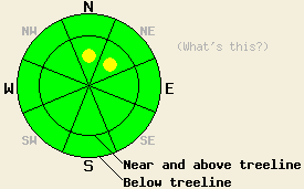
Near and above treeline, very isolated pockets of MODERATE avalanche danger may exist on N-NE aspects, 37 degrees and steeper. For all other areas, avalanche danger is LOW. |
|
|
|
The ridge of high pressure that has brought sunny skies to the forecast area for the past two days is beginning to shift east ahead of an approaching storm system. Warming air temperatures and increasing southwest winds are expected today before another round of snowfall occurs tomorrow. An air temperature inversion is in place this morning with the coldest air below about 7,700'. Ridgetop winds shifted from east to southwest overnight with increasingly stronger gusts expected as the day progresses. This will serve to mix out the air temperature inversion in the mountains and allow for near to above freezing air temperatures today at nearly all elevations.
Observations made yesterday on Castle Peak (Donner Summit area) revealed minor east wind transport of snow, continued settlement, and increasing strength within the recent storm snow (photo and pit profile). The storm snow layer from this past weekend was well bonded to the old early November snow layer at the base of the snowpack. In the vast majority of areas, recent observations have shown that the old early November snow layer at the base of the snowpack is in a state of transitioning from facets to rounds and is gaining strength. To the contrary, one recent observation from Silver Peak (Pole Creek area) showed a more well developed basal facet layer through which fracture propagation was possible.
Avalanche Concern #1: Deep slabs
The concern for deep slab instability is very isolated at best. However, strengthening of the recent storm snow is setting up possible deep slab instability conditions as the weakest portion of the snowpack shifts to the bottom. This makes for a deep cohesive slab of recent storm snow with the weak layer at the interface with the early November old snow layer. With the vast majority of recent field observations showing basal snowpack layer stability and the occasional outlier pointing towards instability, this concern is supported by minimal data and refuted by the majority of field data. Due to the potential consequences of a very isolated but large human triggered avalanche event, this concern cannot be ignored. The most likely location for this event to occur is in near treeline areas on N-NE aspects where a more well developed layer of basal facets exists.
Avalanche Concern #2: Wind loading
Strengthening of southwest ridgetop winds today will cause some wind transport of snow. Very small pockets of wind loading and new slab formation are expected today near and above treeline in lee areas. New slabs today are expected to be very small and not present a significant hazard to backcountry travelers. The exception is locations with significant secondary terrain hazards such as cliffs and deep terrain traps that create significant consequences to anyone caught in an otherwise small and inconsequential avalanche.
Near and above treeline, very isolated pockets of MODERATE avalanche danger may exist on N-NE aspects, 37 degrees and steeper. For all other areas, avalanche danger is LOW.
| 0600 temperature: | 23 to 33 deg. F. |
| Max. temperature in the last 24 hours: | 35 to 39 deg. F. |
| Average wind direction during the last 24 hours: | East shifting to southwest. |
| Average wind speed during the last 24 hours: | 22 mph |
| Maximum wind gust in the last 24 hours: | 57 mph |
| New snowfall in the last 24 hours: | O inches |
| Total snow depth: | 33 to 46 inches |
For 7000-8000 ft: |
|||
| Friday: | Friday Night: | Saturday: | |
| Weather: | Sunny skies in the morning, becoming partly cloudy. | Mostly cloudy skies. | Cloudy skies with snow. |
| Temperatures: | 33 to 40 deg. F. | 16 to 23 deg. F. | 28 to 34 deg. F. |
| Wind direction: | SW | SW | SW |
| Wind speed: | 10 to 15 mph with gusts up to 30 mph in the afternoon. | 10 to 15 mph with gusts to 40 mph. | 15 to 25 mph with gusts to 50 mph. |
| Expected snowfall: | O in. | O in. | 4 to 8 in. |
For 8000-9000 ft: |
|||
| Friday: | Friday Night: | Saturday: | |
| Weather: | Sunny skies in the morning, becoming partly cloudy. | Mostly cloudy skies. | Cloudy skies with snow. |
| Temperatures: | 31 to 38 deg. F. | 15 to 22 deg. F. | 20 to 27 deg. F. |
| Wind direction: | SW | SW | SW |
| Wind speed: | 20 to 30 mph with gusts to 40 mph. Gusts increasing to 55 mph in the afternoon. | 25 to 40 mph with gusts to 50 mph. Gusts increasing to 60 mph after midnight. | 30 to 40 mph with gusts to 60 mph. |
| Expected snowfall: | O in. | O in. | 6 to 9 in. |


This website is owned and maintained by the non-profit arm of the Sierra Avalanche Center. Some of the content is updated by the USDA avalanche forecasters including the forecasts and some observational data. The USDA is not responsible for any advertising, fund-raising events/information, or sponsorship information, or other content not related to the forecasts and the data pertaining to the forecasts.

