In partnership with: 
|
November 27, 2010 at 7:57 am |
|
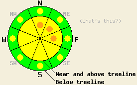
As the day progresses, avalanche danger near and above treeline will increase to MODERATE with pockets of CONSIDERABLE danger on N-NE-E aspects, 35 degrees and steeper. Below treeline, avalanche danger is LOW with pockets of MODERATE danger forming on all aspects in open areas, 35 degrees and steeper. |
|
|
|
Snow is once again falling across the forecast area this morning. New snow amounts of 5 to 14 inches are expected above 7,000' over the next 24 hours with the Sierra Crest most heavily favored. This storm system is a bit warmer than what was experienced this past weekend. Snow levels are expected to rise to near 6,000' this morning before falling to near 4,000' later today. Southwest ridgetop winds increased in speed yesterday and are moderate to strong this morning and will continue through today. Air temperatures at 8,500' are in upper teens to mid 20s across the forecast this morning with warmer air below. The current storm is expected to taper off to snow showers overnight and exit the region tomorrow.
Observations made yesterday on Tamarack Peak (Mount Rose area) and on Becker Peak (Echo Summit area) both showed continued settlement and strengthening of the recent storm snow. Examination of the November 9 basal facet layer showed that fracture propagation along this layer at the base of the recent storm snow was likely at the Tamarack Peak location (pit profile, video). An increase in the temperature gradient within the lower portion of the snowpack has occurred in this area over the past week. Tests performed on the Nov 9 layer on Becker Peak yielded inconsistent results with no strong conclusions (pit profile, photo). Snowpack depth varies greatly across the forecast area from around 2.5 feet up to 6+ feet in wind loaded areas. Sunny skies and above freezing air temperatures at the upper elevations have created some degree of surface melt-freeze crust formation in nearly all sun exposed areas below 9,700'.
Avalanche Concern #1: Storm Snow
As the day progresses, new snowfall is expected to create new unstable slabs. This will occur in response to wind loading and in response to rising snow levels. New slabs are expected in any wind loaded areas, with the largest slabs expected near and above treeline terrain on N-NE-E aspects. Rising snow levels this morning will aid in slab formation by placing higher density snow on top of the initial lower density snow that is deposited at the old/new snow interface. Snowpack failure is expected to occur at or above the old/new snow interface mainly in response to human triggering. Natural avalanche activity will become possible later today, especially in areas where the upper end of forecast new snow amounts are reached.
Avalanche Concern #2: Deep Slabs
In very isolated areas, the potential exists for deep slab instability occurring on the Nov 9 basal facet layer. Most of the recent snowpit data from around the forecast area has not shown the potential for deep slab instability. The Far East Ridge of Tamarack Peak (Mount Rose area) and Silver Peak (Pole Creek area) are the two locations where likely fracture propagation and possible deep slab instability on this layer have been noted. In both areas, the snowpack was tested on a N aspect in below treeline to near treeline terrain that is protected from east winds. Any deep slab avalanches that occur at this time will be very isolated. It will require the right trigger placed at exactly the right spot on exactly the right slope. If collapse of the Nov 9 layer is triggered, significant fracture propagation may occur, causing a large avalanche involving all of the recent storm snow. Due to the potential size of a deep slab avalanche this concern cannot be ignored, despite the fact that the snowpack conditions are appropriate for this avalanche type in very isolated areas only.
As the day progresses, avalanche danger near and above treeline will increase to MODERATE with pockets of CONSIDERABLE danger on N-NE-E aspects, 35 degrees and steeper. Below treeline, avalanche danger is LOW with pockets of MODERATE danger forming on all aspects in open areas, 35 degrees and steeper.
| 0600 temperature: | 18 to 25 deg. F. |
| Max. temperature in the last 24 hours: | 34 to 41 deg. F. |
| Average wind direction during the last 24 hours: | Southwest |
| Average wind speed during the last 24 hours: | 35 mph |
| Maximum wind gust in the last 24 hours: | 77 mph |
| New snowfall in the last 24 hours: | O inches |
| Total snow depth: | 31 to 46 inches |
For 7000-8000 ft: |
|||
| Saturday: | Saturday Night: | Sunday: | |
| Weather: | Cloudy skies with snow. | Cloudy skies with light snow in the evening. A chance of snow after midnight. | Cloudy skies in the morning, becoming mostly cloudy. |
| Temperatures: | 29 to 35 deg. F. | 7 to 14 deg. F. | 17 to 24 deg. F. |
| Wind direction: | SW | W | W |
| Wind speed: | 20 to 30 mph with gusts to 45 mph. Gusts increasing to 55 mph in the afternoon. | 10 to 20 mph with gusts to 40 mph. Gusts decreasing to 30 mph after midnight. | 10 to 15 mph with gusts to 35 mph. |
| Expected snowfall: | 4 to 8 in. | 1 to 3 in. | O in. |
For 8000-9000 ft: |
|||
| Saturday: | Saturday Night: | Sunday: | |
| Weather: | Cloudy skies with snow. | Cloudy skies with light snow in the evening. A chance of snow after midnight. | Cloudy skies in the morning, becoming mostly cloudy. |
| Temperatures: | 20 to 27 deg. F. | 5 to 12 deg. F. | 16 to 22 deg. F. |
| Wind direction: | SW | W | W |
| Wind speed: | 30 to 50 mph with gusts to 75 mph. | 20 to 30 mph with gusts to 50 mph. | 20 to 30 mph with gusts to 45 mph. |
| Expected snowfall: | 6 to 10 in. | 2 to 4 in. | O in. |


This website is owned and maintained by the non-profit arm of the Sierra Avalanche Center. Some of the content is updated by the USDA avalanche forecasters including the forecasts and some observational data. The USDA is not responsible for any advertising, fund-raising events/information, or sponsorship information, or other content not related to the forecasts and the data pertaining to the forecasts.

