In partnership with: 
|
November 29, 2010 at 8:02 am |
|
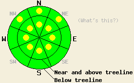
Isolated pockets of MODERATE avalanche danger exist on all aspects 35 degrees and steeper near and above treeline. Below treeline isolated pockets of MODERATE avalanche danger exist on NW-N-NE aspects on slopes 35 degrees and steeper. |
|
|
|
Cold temperatures and moderate northeast winds should continue today due to a small, high-pressure ridge over the forecast area. This ridge should remain in place through today before a weak low-pressure system starts to move into the area tomorrow evening. The wind should start to shift to the southwest and clouds should start to increase tonight as this low approaches. The forecast also calls for slightly warmer temperatures during the day tomorrow.
Another skier triggered avalanche occurred yesterday on Red Lake Peak (near Carson Pass-more info). This slide occurred on a near-treeline, NE-facing slope in complex terrain. The avalanche did injure one person. On Mt. Tallac snowpit tests showed that even though the bonds between storm snow and the old snow surfaces had gained some strength, areas of weakness remain (video and more info). Other tests such as ski cutting test slopes did not show signs of instability. On Sliver Peak (Pole Creek Drainage), in Negro Canyon (Donner Summit area), and on Pint Glass (Mt. Rose area), observations indicated that the bonds between the storm snow and the snow below it continue to gain strength. Snowpit tests on the previously weak layer of snow near the ground indicated that this layer has started to stabilize in the Negro Canyon and Silver Peak areas. However, it remains weak in the Pint Glass area. Tests on the weak, sugary layer near the ground (Nov. 9th facets) in that area indicated that if it starts to break the fracture could easily travel through that layer. Recent observations across the forecast area suggest that this layer only remains weak where the snowpack is more shallow in near and below treeline areas that are sheltered from the east winds and had snow on them in early November. In the Negro Canyon area, the NE winds had started to transport enough snow to form small, new wind slabs on the S-SE aspects near ridgelines by yesterday afternoon.
Overall the snowpack seems to be gaining strength and triggering avalanches is becoming more difficult. However, a few different isolated instabilities do still exist and warrant extra caution.
Avalanche Concern #1: Wind Slabs
The NE winds increased enough yesterday afternoon to start transporting snow and forming new wind slabs on the W-SW-S-SE aspects. These wind slabs grew more last night as the NE winds grew stronger. The added weight of a person on these newly formed wind slabs could cause them to fail today. Even though avalanches involving these wind slabs should remain relatively small, they could have serious consequences in the right locations (near cliffs, other terrain traps, or simply pushing people into shallowly buried rocks).
Avalanche Concern #2: Recent Storm Snow
In most areas the weaknesses associated with the most recent snow have strengthened. However, observations do indicate a few isolated areas where the bonds between the recent storm snow and the older snow beneath it remain weak enough for a person to break them and trigger an avalanche. The most likely places for these types of avalanches will be in more complex terrain (steep couloirs, hanging snowfields, unsupported slopes, heavily wind-loaded areas etc.) on steep NW-N-NE-E facing slopes.
Avalanche Concern #3: Deep Slabs
Avalanche resulting from the failure of the weak, sugary layer of snow near the bottom of the snowpack (Nov 9th facet layer) do remain possible. These types of avalanches should be difficult to trigger unless a person finds the exact right spot on the right slope. Any avalanches resulting from failures of this layer would be large, deep, and dangerous. Areas where this layer remains weak are isolated at best. NW-N-NE aspects near and below treeline that are sheltered from east winds where a shallower snowpack exists and where snow existed on the slope in early November are the most likely areas for this weak layer. Higher elevation areas in the mountains on the east side of Lake Tahoe hold most of the terrain that meets these conditions.
Isolated pockets of MODERATE avalanche danger exist on all aspects 35 degrees and steeper near and above treeline. Below treeline isolated pockets of MODERATE avalanche danger exist on NW-N-NE aspects on slopes 35 degrees and steeper.
| 0600 temperature: | 9 deg. F. |
| Max. temperature in the last 24 hours: | 15 deg. F. |
| Average wind direction during the last 24 hours: | Northeast |
| Average wind speed during the last 24 hours: | 14 until 6 pm last night then increasing to 30-35 mph |
| Maximum wind gust in the last 24 hours: | 47 mph |
| New snowfall in the last 24 hours: | O inches |
| Total snow depth: | 40-54 inches |
For 7000-8000 ft: |
|||
| Monday: | Monday Night: | Tuesday: | |
| Weather: | Sunny | Partly cloudy | Mostly cloudy |
| Temperatures: | 17-24 deg. F. | 13-23 deg. F. | 33-40 deg. F. |
| Wind direction: | Northeast | Southeast | Southwest |
| Wind speed: | 10-15 mph with gusts to 30 mph | up to 10 mph | up to 10 mph with gusts to 25 mph in the afternoon |
| Expected snowfall: | O in. | O in. | O in. |
For 8000-9000 ft: |
|||
| Monday: | Monday Night: | Tuesday: | |
| Weather: | Sunny | Partly cloudy | Mostly cloudy |
| Temperatures: | 13-20 deg. F. | 16-22 deg. F. | 32-39 deg. F. |
| Wind direction: | Northeast | East shifting to the south | Southwest |
| Wind speed: | 15-25 mph with gusts to 40 mph decreasing to gusts to 30 mph in the afternoon | 10-15 mph with gusts to 30 mph | 15-25 mph with gusts to 40 mph |
| Expected snowfall: | O in. | O in. | O in. |


This website is owned and maintained by the non-profit arm of the Sierra Avalanche Center. Some of the content is updated by the USDA avalanche forecasters including the forecasts and some observational data. The USDA is not responsible for any advertising, fund-raising events/information, or sponsorship information, or other content not related to the forecasts and the data pertaining to the forecasts.

