In partnership with: 
|
December 2, 2010 at 7:58 am |
|
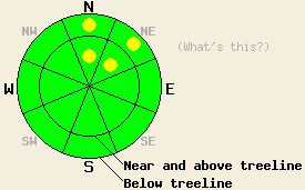
For nearly all areas, avalanche danger is LOW for all elevations and aspects. Very isolated pockets of MODERATE danger exist near and below treeline on N-NE aspects on slopes 35 degrees and steeper where a persistent weak layer exists near the base of the snowpack. Additional pockets of MODERATE danger may form later today if rain falls on the remaining areas of cold unconsolidated snow on N-NE aspects. |
|
|
|
The first in a series of warm precipitation events will spread across the forecast area today. Air temperatures below 9,000' are above freezing in most locations this morning with a few cold pockets down at the valley floors. Southwest ridgetop winds are increasing in speed this morning and are forecast to become moderate to strong in speed by late morning. Light rain and snow are expected with snow levels in the 7,000' to 8,000' range. Total expected snow accumulation above 7,000' is 4 to 8 inches with a few inches of very wet snow accumulating below 7,000' after cold front passage occurs later today. Continued snow showers and decreasing winds are expected on Friday.
Observations made yesterday on Angora Peak (Echo Summit area) and on Pickett Peak (Luther Pass area) both showed continued stabilization of the recent storm snow (pit profiles, photos, videos). This layer has been slow to gain strength. Yesterday was the first day of no reported human triggered avalanche activity since Nov 27th. In both locations, basal facets showed evidence of rounding and significant strength, leaving concerns for basal facet instability to an increasingly isolated number of areas. Surface hoar that has been observed in pockets around the forecast area over the past few days is expected to be destroyed by warm air temperatures and increasing winds prior to the onset of snowfall.
Avalanche Concern #1: Deep Slabs
Avalanches resulting from the failure of the Nov 9th facet layer near the bottom of the snowpack are a possibility in very isolated areas. Human triggering of this avalanche type will be difficult and require passing over the exact right spot on a slope where this layer exists. It is very likely that if a deep slab avalanche occurs, it will not be triggered by the first person to travel on the slope, and in fact the slope may be covered with tracks prior to the avalanche event. Any avalanches resulting from failures of this layer will be large and involve all of the snow accumulated since November 9th. Recent observations across the forecast area suggest that this layer remains weak in a few isolated areas near and below treeline on N-NE aspects that are sheltered from the east winds. Recent field observations indicating instability on this persistent weak layer have been limited to the Mount Rose area.
Avalanche Concern #2: Rain on snow
Snow levels today in the 7,000' to 8,000' range will bring the possibility of rain falling on cold unconsolidated snow that lingers on shaded N-NE aspects. If this occurs, increases in weight with a decrease of strength will occur in the top portion of the snowpack. Shallow human triggered avalanches will become possible in these areas. On other aspects, warm air temperatures and solar radiation over the past two days have prepared the snowpack to handle the small amount of rain that is expected today.
For nearly all areas, avalanche danger is LOW for all elevations and aspects. Very isolated pockets of MODERATE danger exist near and below treeline on N-NE aspects on slopes 35 degrees and steeper where a persistent weak layer exists near the base of the snowpack. Additional pockets of MODERATE danger may form later today if rain falls on the remaining areas of cold unconsolidated snow on N-NE aspects.
| 0600 temperature: | 32 to 37 deg. F. |
| Max. temperature in the last 24 hours: | 38 to 45 deg. F. |
| Average wind direction during the last 24 hours: | Southwest |
| Average wind speed during the last 24 hours: | 20 mph |
| Maximum wind gust in the last 24 hours: | 42 mph |
| New snowfall in the last 24 hours: | O inches |
| Total snow depth: | 41 to 52 inches |
For 7000-8000 ft: |
|||
| Thursday: | Thursday Night: | Friday: | |
| Weather: | Mostly cloudy skies with a chance of rain and snow showers. | Cloudy skies with a chance of snow showers in the evening. Numerous snow showers after midnight. | Cloudy skies with a chance of showers. |
| Temperatures: | 34 to 41 deg. F. | 30 to 34 deg. F. | 37 to 42 deg. F. |
| Wind direction: | SW | SW | SW |
| Wind speed: | 15 to 25 mph with gusts to 40 mph in the morning. Winds increasing to 20 to 30 mph with gusts to 55 mph in the afternoon. | 20 to 35 mph with gusts to 60 mph. | 10 to 20 mph with gusts to 40 mph. Gusts decreasing to 30 mph in the afternoon. |
| Expected snowfall: | 0 to 1 in. | Up to 3 in. | Up to 3 in. |
For 8000-9000 ft: |
|||
| Thursday: | Thursday Night: | Friday: | |
| Weather: | Mostly cloudy skies with a chance of snow showers. | Cloudy skies with a chance of snow showers in the evening. Numerous snow showers after midnight. | Cloudy skies with a chance of showers. |
| Temperatures: | 28 to 35 deg. F. | 28 to 32 deg. F. | 30 to 35 deg. F. |
| Wind direction: | SW | SW | SW |
| Wind speed: | 30 to 45 mph with gusts to 65 mph. Winds increasing to 40 to 55 mph with gusts to 90 mph in the afternoon. | 40 to 55 mph with gusts to 90 mph. | 20 to 35 mph with gusts to 60 mph. Winds decreasing to 10 to 20 mph with gusts to 40 mph in the afternoon. |
| Expected snowfall: | Trace to 1 in. | Up to 3 in. | Up to 3 in. |


This website is owned and maintained by the non-profit arm of the Sierra Avalanche Center. Some of the content is updated by the USDA avalanche forecasters including the forecasts and some observational data. The USDA is not responsible for any advertising, fund-raising events/information, or sponsorship information, or other content not related to the forecasts and the data pertaining to the forecasts.

