In partnership with: 
|
December 3, 2010 at 7:49 am |
|
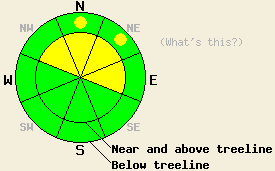
For areas north of Hwy 88, avalanche danger near and above treeline is MODERATE on NW-N-NE-E aspects, 35 degrees and steeper. Below treeline, avalanche danger is LOW with pockets of MODERATE danger on N-NE aspects 35 degrees and steeper. South of Hwy 88, avalanche danger is LOW for all elevations and aspects. |
|
|
|
The main band of moisture that has brought rain and snow to the forecast area yesterday and overnight is moving out of the area. A low pressure system parked offshore will continue to provide warm moist flow through the forecast area for the next couple of days. Snow level has been hovering around 7,000' and is forecast to rise at bit by mid day. New snow amounts above 7,500' are running 1 to 8 inches across the forecast area. The greatest accumulations (5 to 8 inches) have occurred along the Sierra Crest north of Hwy 88 while 3 to 4 inches of new snow as accumulated in the Carson Range. Moderate to strong southwest ridgetop winds continue this morning and are forecast to decrease in speed this afternoon. Air temperatures at 8,500' are in the upper 20s to low 30s this morning with around 2 to 3 degrees of daytime warming expected.
Observations made yesterday on the Far East Ridge of Tamarack Peak continue to show that basal facets in the Mount Rose area warrant ongoing concern. While very difficult to trigger, the Nov 9 basal facet layer shows good potential for fracture propagation to occur (pit profile). Snow surface conditions in the area consisted of cold unconsolidated snow on N-NE aspects and a mix of supportable and breakable melt-freeze crusts on all other aspects. Recent observations from around the forecast area have shown a deeper snowpack void of persistent weak layers along the Sierra Crest. The most recent cycle of reported avalanches occurred Nov 27th through 30th (more info).
Avalanche Concern #1: Storm snow
New snow that has fallen in the past 24 hours is of fairly high density and contains significant water content. On N-NE aspects, this snow has been placed on top of colder lower density snow, creating a classic mechanism for slab formation. Additionally, the wet high density nature of the new snow is expected to allow for significant fracture propagation. While slab depth is expected to be less than 1 foot, wide propagation of avalanches is possible given the characteristics of the new snow. The best window for natural avalanche activity has passed for this event, but human triggered avalanches remain possible today. The areas of greatest instability are expected in wind loaded areas near and above treeline on NW-N-NE-E aspects and below treeline on N-NE aspects where the old snow surface was cold and unconsolidated.
Avalanche Concern #2: Deep Slabs
Avalanches resulting from the failure of the Nov 9th facet layer near the bottom of the snowpack are a possibility in very isolated areas. Recent field observations indicating instability on this persistent weak layer have been limited to the Mount Rose area (map of study site 1, map of study site 2). Human triggering of this avalanche type will be difficult and require passing over the exact right spot on a slope where this layer exists. It is very likely that if a deep slab avalanche occurs, it will not be triggered by the first person to travel on the slope, and in fact the slope may be covered with tracks prior to the avalanche event. Any avalanches resulting from failures of this layer will be large and involve all of the snow accumulated since November 9th. This layer exists in isolated areas near and below treeline on N-NE aspects that are sheltered from the east winds. Near and above treeline terrain on N-NE aspects with east wind exposure had this layer removed by previous wind events. On other aspects it was destroyed by the sun or did not become sufficiently faceted to present an instability problem.
For areas north of Hwy 88, avalanche danger near and above treeline is MODERATE on NW-N-NE-E aspects, 35 degrees and steeper. Below treeline, avalanche danger is LOW with pockets of MODERATE danger on N-NE aspects 35 degrees and steeper. South of Hwy 88, avalanche danger is LOW for all elevations and aspects.
| 0600 temperature: | 26 to 32 deg. F. |
| Max. temperature in the last 24 hours: | 34 to 41 deg. F. |
| Average wind direction during the last 24 hours: | Southwest |
| Average wind speed during the last 24 hours: | 45 mph |
| Maximum wind gust in the last 24 hours: | 74 mph |
| New snowfall in the last 24 hours: | 1 to 8 inches |
| Total snow depth: | 36 to 54 inches |
For 7000-8000 ft: |
|||
| Friday: | Friday Night: | Saturday: | |
| Weather: | Cloudy skies with scattered rain and snow showers. | Cloudy skies with isolated snow showers. | Cloudy skies with scattered rain and snow showers. |
| Temperatures: | 33 to 40 deg. F. | 20 to 28 deg. F. | 32 to 39 deg. F. |
| Wind direction: | SW shifting to S | S | S |
| Wind speed: | 15 to 25 mph with gusts to 50 mph. Winds decreasing to 10 to 15 mph with guts to 30 mph in the afternoon. | 10 to 15 mph with gusts to 25 mph in the evening. | 10 to 15 mph. |
| Expected snowfall: | 0 to 1 in. | 0 to trace in. | 0 to trace in. |
For 8000-9000 ft: |
|||
| Friday: | Friday Night: | Saturday: | |
| Weather: | Cloudy skies with scattered snow showers. | Cloudy skies with isolated snow showers. | Cloudy skies with scattered snow showers. |
| Temperatures: | 28 to 35 deg. F. | 20 to 28 deg. F. | 28 to 35 deg. F. |
| Wind direction: | SW shifting to S | S | S |
| Wind speed: | 30 to 40 mph with gusts to 65 mph. Winds decreasing to 10 to 20 mph with gusts to 40 mph in the afternoon. | 10 to 15 mph with gusts to 35 mph in the evening. | 15 to 25 mph with gusts to 35 mph. |
| Expected snowfall: | Up to 2 in. | 0 to trace in. | 0 to trace in. |


This website is owned and maintained by the non-profit arm of the Sierra Avalanche Center. Some of the content is updated by the USDA avalanche forecasters including the forecasts and some observational data. The USDA is not responsible for any advertising, fund-raising events/information, or sponsorship information, or other content not related to the forecasts and the data pertaining to the forecasts.

