In partnership with: 
|
December 6, 2010 at 7:57 am |
|
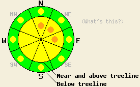
Near and above treeline pockets of CONSIDERABLE avalanche danger exist on N-NE-E aspects 35 degrees and steeper with MODERATE danger on other aspects. Below treeline pockets of MODERATE danger exist on open slopes steeper than 35 degrees. |
|
|
|
8-13 inches of snow fell along the Sierra Crest between 8pm last night and 4 am this morning. East of Lake Tahoe 4-6 inches of new snow accumulated. Snow levels started around 7900 ft. and dropped to around 6000 ft by midnight last night. The winds accompanying this snow averaged between 30 and 40 mph with gusts in the 70's and 80's. Most of the time these winds came from the southwest; however, a few shifts more to the south did occur during the night. Scattered snow showers should continue this morning across the region. As the current low pressure moves eastward today, the snow showers should end; the winds should decrease; and the clouds should decrease. By tomorrow the clouds should start to increase again ahead of another low pressure.
Yesterday observations in the Deep Creek area, in the Mt. Rose area, and in the Bear Valley area pointed to a mostly stable snowpack. Layer bonding tests, ski cuts, and general observations indicated that the 1-4 inches of new snow from the night of Dec. 4th had bonded well to the mix of dense storm snow and crusts that existed below it. Snowpit data also showed that the other layers in the snowpack continue to gain strength. One snowpit from the Pint Glass (video and more info) on a sheltered, N-facing slope with a shallow snowpack did contain the Nov.9th facet layer. Even though this layer appears to be slowly gaining strength, tests on this layer still indicate that if this layer breaks the resulting fracture could easily travel a long way along this layer.
Avalanche Concern #1: Wind Slabs
Strong winds and new snow formed new wind slabs on leeward aspects during the night. As the winds continue this morning, these wind slabs will continue to grow in thickness and extent. In many areas these wind slabs have formed faster than they can bond to the snow below them. Several of these slabs probably already avalanched during the night. Even though most of the natural avalanche activity should have occurred last night and early this morning, natural avalanches will remain possible today on pockets of terrain where the most wind-loading has occurred and where strong wind-loading continues to occur. Human triggered avalanche remain possible on any wind-loaded slope above or below treeline. Tender cornices should have formed above many of these newly wind-loaded slopes and could easily break in response to the added weight of a person. Use clues like cornices, blowing snow, ripples, drifts, and other wind created textures to tell which slopes the wind has loaded. N-NE-E wind-loaded aspects and NW-SE cross-loaded aspects hold the best potential for fragile wind slabs today.
Avalanche Concern #2: Storm Snow Weaknesses
Different types of snow crystals (like graupel) fell during the storm due to changing snowfall rates, winds, and temperatures during the night. These different crystals will form small differences in the storm snow that may create weaknesses within the storm snow. These weaknesses should quickly strengthen. However, human-triggered soft slab avalanches will remain possible due to failures in the storm snow on pockets of open terrain steeper than 37 degrees that have received the most new snow. Expect some sluffing in the new snow on steeper terrain as well.
Avalanche Concern #3: Deep Slabs
Observations show the Nov 9th facet layer (weak, sugary snow) near the bottom of the snowpack slowly gaining strength. Areas where avalanches resulting from the failure of this layer remain possible are growing more and more isolated and more and more disconnected. These types of avalanches should be very difficult to trigger unless a person finds the exact right spot on a slope where this layer exists. These kind of avalanches can be triggered even on a slope that has seen several people descend it safely. Observations suggest that this layer only remains weak where a shallower snowpack exists on near and below treeline N-NE aspects that are sheltered from the east winds and had snow on them in early November. Observers have only found this persistent weak layer in the the Mt. Rose area so far.
Near and above treeline pockets of CONSIDERABLE avalanche danger exist on N-NE-E aspects 35 degrees and steeper with MODERATE danger on other aspects. Below treeline pockets of MODERATE danger exist on open slopes steeper than 35 degrees.
| 0600 temperature: | 24-29 deg. F. |
| Max. temperature in the last 24 hours: | 34-38 deg. F. |
| Average wind direction during the last 24 hours: | Southwest |
| Average wind speed during the last 24 hours: | 35 mph |
| Maximum wind gust in the last 24 hours: | 81 mph |
| New snowfall in the last 24 hours: | 8-13 inches |
| Total snow depth: | 41-58 inches |
For 7000-8000 ft: |
|||
| Monday: | Monday Night: | Tuesday: | |
| Weather: | Mostly cloudy with scattered snow showers this morning becoming partly cloudy this afternoon. | Partly cloudy this evening becoming mostly cloudy after midnight. | Mostly cloudy |
| Temperatures: | 30-37 deg. F. | 29-37 deg. F. | 38-45 deg. F. |
| Wind direction: | Southwest | South | South |
| Wind speed: | 20-30 mph with gusts to 60 mph in the morning | around 10 mph | around 10 mph |
| Expected snowfall: | trace in. | O in. | O in. |
For 8000-9000 ft: |
|||
| Monday: | Monday Night: | Tuesday: | |
| Weather: | Mostly cloudy with scattered snow showers this morning becoming partly cloudy this afternoon. | Partly cloudy this evening becoming mostly cloudy after midnight. | Mostly cloudy |
| Temperatures: | 26-33 deg. F. | 24-30 deg. F. | 38-45 deg. F. |
| Wind direction: | Southwest | Southwest | South |
| Wind speed: | 20-30 mph with gusts to 90 mph in the morning decreasing to 15-20 mph with gusts to 40 mph in the afternoon | 10-20 mph with gusts to 35 mph increasing to 20-30 mph with gusts to 45 mph after midnight | 15-25 mph with gusts to 35 mph |
| Expected snowfall: | trace in. | O in. | O in. |


This website is owned and maintained by the non-profit arm of the Sierra Avalanche Center. Some of the content is updated by the USDA avalanche forecasters including the forecasts and some observational data. The USDA is not responsible for any advertising, fund-raising events/information, or sponsorship information, or other content not related to the forecasts and the data pertaining to the forecasts.

