In partnership with: 
|
December 9, 2010 at 7:55 am |
|
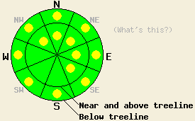
Near and above treeline, avalanche danger is LOW with pockets of MODERATE danger on NW-N-NE-E-SE aspects, 37 degrees and steeper. Below treeline, avalanche danger is LOW with pockets of MODERATE danger in open areas 37 degrees and steeper. |
|
|
|
Warm westerly flow will continue to bring light rain and snow showers to the forecast area today. Snow levels rose as high as 8,000' to 8,300' yesterday afternoon before falling to around 7,700 to 8,000' early this morning. Up to 6 inches of new snow has accumulated at the highest elevations along the Sierra Crest in the northern portion of the forecast area. All other areas have seen little to no accumulation or rain on snow. Air temperatures at 8,500' held a warming trend all through yesterday, rising above freezing around 2 to 3 pm and remaining above freezing until around 3 am this morning. Ridgetop winds are shifting from southwest to west this morning and will remain moderate in speed through tomorrow.
Observations made yesterday on Talking Mountain (Echo Summit area) revealed wet and humid conditions at 8,600'. Intentionally dropping small cornice sections onto the N aspect below treeline slopes below created shallow wet loose surface snow instabilities that were the same width as the cornice section (photos, pit profile, more info). No fracture propagation of surface slabs on these slopes was observed. In the Mount Rose area, observers reported similar conditions during the late afternoon hours despite all precipitation falling as light snow. In Upper Ophir Creek (Mount Rose area) observations specifically targeting the Nov 9 basal facet layer noted continued rounding of crystals and unlikely fracture propagation along this layer at 8,900 on a NE aspect 40 degree slope in below treeline terrain (pit profile, videos, more info).
Avalanche Concern #1: Wet snow
As warm wet conditions continue today, areas of surface wet snow instabilities will be found in steep terrain where either rain has fallen on the snowpack or warm humid air has saturated the snow surface. A mixed bag of conditions is expected today as some of these areas above 8,500' may have refrozen overnight. Most areas below 8,000' will have remained wet and unfrozen overnight. Any wet snow instabilities that occur are expected as human triggered point releases. The greatest hazard will be secondary terrain exposure such as cliffs, rocks, trees, and terrain traps that could drastically increase the consequences for anyone caught in a small wet loose avalanche.
Avalanche Concern #2: Storm snow
Pockets of stubborn, difficult to trigger high density storm snow slabs are expected to have formed at and above 9,000'. The largest slabs are expected to have formed along the Sierra Crest in the northern portion of the forecast area where 4 to 6 inches of new snow has accumulated and will be deeper in wind loaded areas. Any human triggered slab avalanche activity that occurs today will most likely occur above 9,000' in wind loaded near and above treeline terrain on NW-N-NE-E-SE aspects.
Avalanche Concern #3: Deep Slabs
Human triggered deep slab avalanche activity involving the Nov 9 basal facet layer falls in the unlikely but not impossible category. The remaining evidence for this lingering instability concern is limited to the Mount Rose area on isolated near and below treeline N-NE aspects that are east wind protected. The Nov 9 layer continues to show evidence of rounding and strength gain in most areas. A few isolated snowpit tests continue to indicate that fracture propagation is still likely to occur once snowpack failure is triggered. Due to the uneven coverage and patchy, disconnected distribution of this layer, areas where failure could occur on a slope scale are very isolated at best. With continued strength gains in the snow that makes up the overlying slab, areas where rocks and logs stick up through the weak layer and into the overlying slab are anchoring and further contributing to slope stability despite the presence of this weak basal facet layer.
Near and above treeline, avalanche danger is LOW with pockets of MODERATE danger on NW-N-NE-E-SE aspects, 37 degrees and steeper. Below treeline, avalanche danger is LOW with pockets of MODERATE danger in open areas 37 degrees and steeper.
| 0600 temperature: | 28 to 34 deg. F. |
| Max. temperature in the last 24 hours: | 37 to 39 deg. F. |
| Average wind direction during the last 24 hours: | Southwest |
| Average wind speed during the last 24 hours: | 58 mph |
| Maximum wind gust in the last 24 hours: | 86 mph |
| New snowfall in the last 24 hours: | 0 to 4 inches |
| Total snow depth: | 40 to 53 inches |
For 7000-8000 ft: |
|||
| Thursday: | Thursday Night: | Friday: | |
| Weather: | Cloudy skies with numerous rain and snow showers. | Cloudy skies with scattered rain and snow showers. | Cloudy skies with scattered rain and snow showers. |
| Temperatures: | 37 to 44 deg. F. | 25 to 33 deg. F. | 38 to 45 deg. F. |
| Wind direction: | W | W | W |
| Wind speed: | 10 to 20 mph with gusts to 35 mph. | 10 to 15 mph with gusts to 30 mph. | 10 to 15 mph with gusts to 30 mph. Winds increasing to 15 to 25 mph with gusts to 45 mph in the afternoon. |
| Expected snowfall: | Up to 2 in. | 0 to trace in. | 0 to trace in. |
For 8000-9000 ft: |
|||
| Thursday: | Thursday Night: | Friday: | |
| Weather: | Cloudy skies with numerous snow showers. | Cloudy skies with scattered snow showers. | Cloudy skies with scattered snow showers. |
| Temperatures: | 32 to 38 deg. F. | 25 to 33 deg. F. | 33 to 38 deg. F. |
| Wind direction: | W | W | W |
| Wind speed: | 20 to 35 mph with gusts to 70 mph. Gusts decreasing to 50 mph in the afternoon. | 20 to 30 mph with gusts to 50 mph. Gusts increasing to 60 mph after midnight. | 20 to 35 mph with gusts to 60 mph. |
| Expected snowfall: | Up to 2 in. | 0 to trace in. | 0 to trace in. |


This website is owned and maintained by the non-profit arm of the Sierra Avalanche Center. Some of the content is updated by the USDA avalanche forecasters including the forecasts and some observational data. The USDA is not responsible for any advertising, fund-raising events/information, or sponsorship information, or other content not related to the forecasts and the data pertaining to the forecasts.

