In partnership with: 
|
December 10, 2010 at 7:53 am |
|
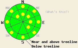
Near and above treeline, avalanche danger is LOW with pockets of MODERATE danger on NW-N-NE-E-SE aspects, 37 degrees and steeper. Below treeline, avalanche danger is LOW with pockets of MODERATE danger in open areas 37 degrees and steeper. |
|
|
|
Another weak weather disturbance has moved into the forecast area overnight. Air temperatures are on a warming trend this morning and snow level is on the rise. Remote sensors at 8,500' are reporting the warmest air temperatures observed at that elevation in the past 24 hours. All remote sensors along the Sierra Crest in the 8,000' to 8,800' range are showing above freezing air temperatures, an increase in accumulated rain water equivalent and a decrease in snowpack height, indicating that rain is falling at those locations. The vast majority of precipitation over the past few days has been focused on the Sierra Crest with minimal spill over to the Carson Range. Storm snow totals above 9,000' along the Sierra Crest are running 5 to 10 inches while the Carson Range has picked up 1 to 2 inches. Ridgetop winds have shifted back to the southwest and have increased in speed this morning as the current weather system is moving through the area. Moderate to strong ridgetop winds are expected to continue into this evening. Precipitation is forecast to peak late this morning and decrease during the afternoon. High pressure will slowly begin to build in over the forecast area with continued shower activity tonight and tomorrow.
Observations made yesterday on Jake's Peak (West Shore Tahoe area) revealed a good picture of the state of the snowpack along the Sierra Crest between 6,800' and 9,200'. Below 8,000' no significant new snow had accumulated with rain water percolating into the top 3 inches of the snowpack. Between 8,000' and 9,000', 1 to 3 inches of wet new snow sat on top of unfrozen rain wetted old snow. Above 9,000' up to 5 inches of new snow sat on top of and was well bonded to a 1/2 inch thick rain crust. Some evidence of recent rain on snow was evident all the way up to the summit at 9,170'. Skier triggered roller balls that built to 6 to 12 inches in diameter occurring between 8,200' and 8,500' provided the only evidence of wet snow instability. Snowpit data obtained at 7,850' on an ENE aspect 40 degree slope in below treeline terrain yielded no additional evidence of instability (pit profile). Ski cuts on steep convex test slopes above 9,000' produced no evidence of slab instability in this particular area. Kirkwood Pro Patrol reported avalanche reduction work performed yesterday morning at 9,200' on above treeline NE-E aspects produced some slab avalanches with crown depths in wind loaded areas of 8 inches to over a foot.
Avalanche Concern #1: Wet snow
As warm wet conditions continue today, areas of surface wet snow instabilities are expected to continue in steep terrain where either rain has fallen on the snowpack or warm humid air has saturated the snow surface. Any wet snow instabilities that occur are expected as human triggered point releases. Expect this to take the form of either wet slushy snow below 8,000' or at higher elevations as wet new snow moving and entraining additional snow as it moves down hill. The greatest hazard will be secondary terrain exposure such as cliffs, rocks, trees, and terrain traps that could drastically increase the consequences for anyone caught in a small wet loose avalanche.
Avalanche Concern #2: Storm snow
Areas of high density storm snow slabs have formed at and above 9,000'. The largest slabs are expected to have formed mainly along the Sierra Crest where up to 10 inches of new snow has accumulated above 9,000' and will be deeper in wind loaded areas. Any human triggered slab avalanche activity that occurs today will most likely occur above 9,000' in wind loaded near and above treeline terrain on NW-N-NE-E-SE aspects.
Near and above treeline, avalanche danger is LOW with pockets of MODERATE danger on NW-N-NE-E-SE aspects, 37 degrees and steeper. Below treeline, avalanche danger is LOW with pockets of MODERATE danger in open areas 37 degrees and steeper.
| 0600 temperature: | 32 to 37 deg. F. |
| Max. temperature in the last 24 hours: | 32 to 38 deg. F. |
| Average wind direction during the last 24 hours: | West shifting to southwest |
| Average wind speed during the last 24 hours: | 47 mph |
| Maximum wind gust in the last 24 hours: | 85 mph |
| New snowfall in the last 24 hours: | trace to 1 inches |
| Total snow depth: | 37 to 53 inches |
For 7000-8000 ft: |
|||
| Friday: | Friday Night: | Saturday: | |
| Weather: | Cloudy skies with scattered rain and snow showers. | Cloudy skies with a chance of rain and snow. | Mostly cloudy skies with a slight chance of rain. |
| Temperatures: | 38 to 43 deg. F. | 27 to 34 deg. F. | 42 to 47 deg. F. |
| Wind direction: | SW | W | W |
| Wind speed: | 20 to 30 mph with gusts to 45 mph. | 10 to 15 mph with gusts up to 30 mph in the evening. | 10 to 15 mph with gusts up to 30 mph in the afternoon. |
| Expected snowfall: | 0 to trace in. | 0 to trace in. | O in. |
For 8000-9000 ft: |
|||
| Friday: | Friday Night: | Saturday: | |
| Weather: | Cloudy skies with scattered rain and snow showers. | Cloudy skies with a chance of snow. | Mostly cloudy skies with a slight chance of rain and snow. |
| Temperatures: | 30 to 40 deg. F. | 26 to 33 deg. F. | 33 to 43 deg. F. |
| Wind direction: | SW | W | W |
| Wind speed: | 30 to 50 mph with gusts to 65 mph. | 20 to 30 mph with gusts to 55 mph. Gusts decreasing to 30 mph after midnight. | 10 to 20 mph with gusts to 45 mph. Winds increasing to 20 to 30 mph with gusts to 55 mph in the afternoon. |
| Expected snowfall: | Up to 2 in. | 0 to trace in. | 0 to trace in. |


This website is owned and maintained by the non-profit arm of the Sierra Avalanche Center. Some of the content is updated by the USDA avalanche forecasters including the forecasts and some observational data. The USDA is not responsible for any advertising, fund-raising events/information, or sponsorship information, or other content not related to the forecasts and the data pertaining to the forecasts.

