In partnership with: 
|
December 11, 2010 at 8:17 am |
|
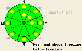
Near and above treeline, LOW avalanche danger exists in most areas with isolated pockets of MODERATE danger on N-NE-E aspects, 37 degrees and steeper. Below treeline, pockets of MODERATE avalanche danger exist in open areas 37 degrees and steeper. |
|
|
|
Rain and snow showers continued yesterday with snow level between 8500 ft and 9500 ft. Some scattered showers could continue in the mountains this morning. As a high pressure ridge forms over the forecast area, the showers should dissipate. The clouds should also clear out this evening. This high pressure should bring sunny, spring-like weather to the region tomorrow with daytime highs in mid 40's and low 50's above 8000 ft.
Near Carson Pass, rain showers continued through midday up to 9400 ft. A layer of wet, saturated snow up to 10 inches thick existed on most aspects up to 9000 ft. Above 9000 ft on the northerly aspects, this wet snow layer only reached 2-4 inches in thickness. Skiers triggered roller-balls, point-releases, and ski-width sluffs that entrained all of this wet snow on 37-40 degree test slopes on a variety of aspects in this area. Snow level dropped to 8500 ft by 3 pm. A thin, breakable crust formed on the snow surface as the temperatures started to cool down. Snowpit data and layer bonding tests on an ENE facing slope at 9300 ft. on Meiss Ridge indicated that fracture propagation in the wet snow was unlikely. These tests also showed that the recent storm snow had gained some strength but that it had not consolidated completely.
Avalanche Concern #1: Wet-Snow Instabilities
Cloud cover and warm temperatures up to 8200 ft should have prevented a strong refreeze last night. As the day warms up, more melting will occur in the snowpack. Water formed as the snow melts will percolate farther into the snow creating a thicker layer of wet, saturated surface snow. The water in this saturated layer will melt the bonds holding this layer together and weaken this layer allowing human-triggered, wet-snow instabilities to remain possible today. Roller balls, point releases, and sluffs should comprise the majority of these wet-snow instabilities. Even though these slow-moving, wet, loose snow avalanches may not be enough to bury a person, they could push a person into an area with serious consequences like over a cliff, into a creek or gully, or into some other terrain trap. These wet-snow instabilities could exist on any slope steeper than 37 degrees with a significant layer of wet, surface snow.
Avalanche Concern #2: Wind Slabs
Some isolated areas where human-triggerable wind slabs remain could still exist today. These lingering fragile wind slabs will most likely exist on N-NE-E aspect in the most heavily wind-loaded areas and in wind-loaded complex terrain (unsupported snow slopes, couloirs, cliffy areas, etc) near and above treeline.
Near and above treeline, LOW avalanche danger exists in most areas with isolated pockets of MODERATE danger on N-NE-E aspects, 37 degrees and steeper. Below treeline, pockets of MODERATE avalanche danger exist in open areas 37 degrees and steeper.
| 0600 temperature: | 30-33 deg. F. |
| Max. temperature in the last 24 hours: | 32-38 deg. F. |
| Average wind direction during the last 24 hours: | West southwest |
| Average wind speed during the last 24 hours: | 35 mph |
| Maximum wind gust in the last 24 hours: | 85 mph |
| New snowfall in the last 24 hours: | O inches |
| Total snow depth: | 35-51 inches |
For 7000-8000 ft: |
|||
| Saturday: | Saturday Night: | Sunday: | |
| Weather: | Partly cloudy with a slight chance of showers this morning. | Partly cloudy becoming clear overnight. | Sunny |
| Temperatures: | 42-48 deg. F. | 31-39 deg. F. | 45-55 deg. F. |
| Wind direction: | West | Southwest | Southwest |
| Wind speed: | 10-15 mph with gusts to 30 mph | 10 mph decreasing overnight | up to 10 mph |
| Expected snowfall: | O in. | O in. | O in. |
For 8000-9000 ft: |
|||
| Saturday: | Saturday Night: | Sunday: | |
| Weather: | Partly cloudy with a slight chance of showers this morning. | Partly cloudy becoming clear overnight. | Sunny |
| Temperatures: | 32-42 deg. F. | 32-42 deg. F. | 42-52 deg. F. |
| Wind direction: | West | Northwest | Southwest |
| Wind speed: | 25-35 mph with gusts to 55 mph | 10-20 mph with gusts to 40 mph | 10-15 mph with gusts to 30 mph |
| Expected snowfall: | O in. | O in. | O in. |


This website is owned and maintained by the non-profit arm of the Sierra Avalanche Center. Some of the content is updated by the USDA avalanche forecasters including the forecasts and some observational data. The USDA is not responsible for any advertising, fund-raising events/information, or sponsorship information, or other content not related to the forecasts and the data pertaining to the forecasts.

