In partnership with: 
|
December 16, 2010 at 8:02 am |
|
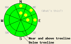
Avalanche danger is LOW for the vast majority of all elevations and aspects. Very isolated pockets of MODERATE danger may exist on N-NE-E aspects, 37 degrees and steeper due to developing deep slab concerns. |
|
|
|
One more day of sunshine will hold over the forecast area today. A colder air mass is in place over the forecast area this morning with air temperatures in the teens at nearly all locations. Ridgetop winds have shifted to the southeast overnight and have become very light. A slight increase in wind speed is expected this afternoon, but generally light winds are expected to last through today. A well advertised major storm system will impact the forecast area beginning Friday and continuing into next week with the potential for several feet of new snow (NWS video weather briefing).
Observations made yesterday on Mt. Lola (Independence Lake area), Jake's Peak (West Shore Tahoe area), and Powderhouse Peak (Luther Pass area) all revealed rapid stabilization of the mid and lower portions of the recent storm snow. In the upper portion of the recent storm snow, very long running loose snow avalanches (sluffs) were observed in wind protected areas where slab formation was absent. On Mt. Lola, evidence of four small natural avalanches that likely occurred around 9pm on Tuesday were visible in a heavily wind loaded above treeline area at 9,080' in the NE-E aspect summit bowl. Crown depth was around 1 foot deep. Snowpit tests easily identified this storm snow weakness, but fracture propagation had become unlikely on this weakness by mid day yesterday.
On Jake's Peak and on Powderhouse Peak snowpit data revealed a developing concern for deep slab instability occurring at uppermost rain crust that formed on Dec 10th and was buried on Dec 14th (henceforth referred to as the Dec 14 rain crust). Small near crust facets have formed above and below the Dec 14 rain crust and are presenting as a weak layer of developing concern. Snowpit test results indicating likely fracture propagation were observed on Jake's Peak at 8,600' on a ENE aspect 38 degree slope in below treeline terrain (pit profile, video, more info). On Powderhouse Peak this same layer, but with unlikely fracture propagation potential was observed in snowpit data obtained at 9,200' on a N aspect 46 degree slope in below treeline terrain (pit profile, more info).
Developing Avalanche Concern: Deep slabs
With the recent storm snow showing good evidence of stabilization, concerns are shifting towards evidence pointing to a developing deep slab avalanche concern. As the recent storm snow continues to stabilize and gain strength, it will become a cohesive slab sitting on top of the weaker near crust facets at the Dec 14 rain crust. This is mainly a concern going forward into the storm cycle of the next few days. However, it could occur sooner in response to human triggering if the continued rapid stabilization of the recent storm snow develops a sufficiently cohesive slab. If any deep slab avalanche activity were to occur today, it is expected as very isolated. With this avalanche type, significant destructive potential, burial, and injury are possible due to snowpack failure around 2 or more feet deep in the snowpack.
Avalanche danger is LOW for the vast majority of all elevations and aspects. Very isolated pockets of MODERATE danger may exist on N-NE-E aspects, 37 degrees and steeper due to developing deep slab concerns.
| 0600 temperature: | 13 to 18 deg. F. |
| Max. temperature in the last 24 hours: | 19 to 31 deg. F. |
| Average wind direction during the last 24 hours: | Southwest shifting to southeast |
| Average wind speed during the last 24 hours: | 18 mph |
| Maximum wind gust in the last 24 hours: | 45 mph |
| New snowfall in the last 24 hours: | O inches |
| Total snow depth: | 40 to 65 inches |
For 7000-8000 ft: |
|||
| Thursday: | Thursday Night: | Friday: | |
| Weather: | Partly cloudy skies. | Mostly cloudy skies with a slight chance of snow after midnight. | Cloudy skies with snow. |
| Temperatures: | 27 to 32 deg. F. | 20 to 25 deg. F. | 27 to 32 deg. F. |
| Wind direction: | SE | SW | SW |
| Wind speed: | Up to 10 mph. | Up to 10 mph. | 10 to 20 mph with gusts to 30 mph in the afternoon. |
| Expected snowfall: | O in. | 0 to trace in. | 3 to 6 in. |
For 8000-9000 ft: |
|||
| Thursday: | Thursday Night: | Friday: | |
| Weather: | Partly cloudy skies. | Mostly cloudy skies with a slight chance of snow after midnight. | Cloudy skies with snow. |
| Temperatures: | 22 to 30 deg. F. | 20 to 27 deg. F. | 23 to 28 deg. F. |
| Wind direction: | SE | S shifting to SW | SW |
| Wind speed: | 10 to 15 mph with gusts to 25 mph in the afternoon. | Around 10 mph increasing to 15 to 25 mph with gusts to 40 mph after midnight. | 15 to 25 mph with gusts to 40 mph. Winds increasing to 25 to 35 mph with gusts to 50 mph in the afternoon. |
| Expected snowfall: | O in. | 0 to trace in. | 4 to 7 in. |


This website is owned and maintained by the non-profit arm of the Sierra Avalanche Center. Some of the content is updated by the USDA avalanche forecasters including the forecasts and some observational data. The USDA is not responsible for any advertising, fund-raising events/information, or sponsorship information, or other content not related to the forecasts and the data pertaining to the forecasts.

