In partnership with: 
|
December 24, 2010 at 7:57 am |
|
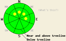
LOW avalanche danger exists in most areas above and below treeline. Some isolated pockets of MODERATE avalanche danger remain near and above treeline on NW-N-NE-E aspects, 37 degrees and steeper. |
|
|
|
The lingering high pressure ridge should keep the region dry until tomorrow afternoon when the next low pressure arrives over the Sierra. This low should begin to push more cloud cover into the area over the next 24 hours. The south and southwest winds should also continue to increase ahead of this system. A chance of snow will develop by tomorrow afternoon as this low arrives.
Shallow, small, soft wind slabs that failed due to refrigerator-sized cornices pieces falling on them did exist on wind-loaded, N-NE test slopes steeper than 39 degrees in near and above treeline terrain on Silver Peak yesterday (videos). On wind-loaded tests slopes less steep than 38 degrees, in less wind-loaded areas, and on test slopes below treeline on Silver Peak, smaller pieces of cornices dropped onto the slopes and ski cuts only caused shallow (3-4 inch deep) sluffs or nothing at all. On Jake's Peak observations showed a mostly stable snowpack with similar small, surface sluffs occurring in the steepest terrain. Layer bonding tests indicated that bonds between the recent snow and the older snow as well as between the deeper layers in the snowpack continue to strengthen. Soft, unconsolidated snow remained on the surface on the shaded slopes on both Jake's and Silver Peak yesterday; however, on the sun-exposed southerly slopes a thin sun crust had started to form on top of wet, sticky snow.
Primary avalanche concern: Wind Slabs
Human triggered avalanches will remain possible today in isolated pockets of wind-loaded, NW-N-NE-E aspects near and above treeline on slopes steeper than 37 degrees. Wind-loaded complex or extreme terrain (unsupported slopes, couloirs, cliffy areas, etc) will be the most likely areas for these pockets of instability. Additional wind-loading may occur today as the winds increase adding more snow to these wind slabs. Most avalanches due to failure of these wind slabs should remain shallow within the most recent snow; however, serious consequences could result from these small slides due to their locations. Failures that step down into the older storm snow remain unlikely but not impossible. Cornices that exist above wind-loaded slopes will also remain sensitive to human triggering today.
LOW avalanche danger exists in most areas above and below treeline. Some isolated pockets of MODERATE avalanche danger remain near and above treeline on NW-N-NE-E aspects, 37 degrees and steeper.
| 0600 temperature: | 22-27 deg. F. |
| Max. temperature in the last 24 hours: | 29-34 deg. F. |
| Average wind direction during the last 24 hours: | South southwest |
| Average wind speed during the last 24 hours: | 25-30 mph |
| Maximum wind gust in the last 24 hours: | 52 mph |
| New snowfall in the last 24 hours: | O inches |
| Total snow depth: | 65-92 inches |
For 7000-8000 ft: |
|||
| Friday: | Friday Night: | Saturday: | |
| Weather: | Partly cloudy | Mostly cloudy | Cloudy with a slight chance of snow in the afternoon. |
| Temperatures: | 39-45 deg. F. | 17-24 deg. F. | 34-41 deg. F. |
| Wind direction: | Southwest | South | South |
| Wind speed: | 10 mph with gusts to 25 mph | 10-15 mph with gusts to 30 mph | 10-20 mph with gusts to 40 mph |
| Expected snowfall: | O in. | O in. | O in. |
For 8000-9000 ft: |
|||
| Friday: | Friday Night: | Saturday: | |
| Weather: | Partly cloudy | Mostly cloudy | Cloudy with a slight chance of snow in the afternoon. |
| Temperatures: | 32-39 deg. F. | 20-27 deg. F. | 31-38 deg. F. |
| Wind direction: | Southwest | South | South |
| Wind speed: | 25-35 mph increasing to 30-45 mph with gusts to 65 mph in the afternoon | 30-45 mph with gusts to 65 mph | 30-45 mph with gusts to 60 mph increasing to 70 mph in the afternoon |
| Expected snowfall: | O in. | O in. | O in. |


This website is owned and maintained by the non-profit arm of the Sierra Avalanche Center. Some of the content is updated by the USDA avalanche forecasters including the forecasts and some observational data. The USDA is not responsible for any advertising, fund-raising events/information, or sponsorship information, or other content not related to the forecasts and the data pertaining to the forecasts.

