In partnership with: 
|
January 3, 2011 at 7:42 am |
|
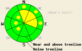
For areas south of Hwy 88, MODERATE avalanche danger exists near and above treeline on N-NE-E aspects, 35 degrees and steeper. Below treeline, avalanche danger is LOW with pockets of MODERATE danger on N-NE-E aspects, 35 degrees and steeper. Isolated pockets of MODERATE danger may form today near and above treeline on SW-W-NW aspects 37 degrees and steeper. For areas north of Hwy 88, avalanche danger early this morning is LOW for all elevations and aspects. Isolated pockets of MODERATE danger may form today near and above treeline on SW-W-NW aspects 37 degrees and steeper. |
|
|
|
The storm system that passed through the forecast area Saturday night and Sunday deposited 1 to 4 inches of new snow in areas north of Hwy 88. South of Hwy 88, 12 inches of new snow accumulated in the Bear Valley/Ebbetts Pass area. Snowfall accumulations for Sunday were well below forecast amounts with a trace of new snow in the northern portion of the forecast area and up to 5 inches in the far southern portion of the forecast area. Cloud cover is decreasing this morning with sunny skies expected across the forecast area by this afternoon. Ridgetop winds for most of yesterday were light and variable before filling in out of the east and increasing to moderate in speed overnight. Air temperatures this morning at 8,500' are in the mid teens with around 5 degrees of daytime warming expected.
Observations made yesterday on Rose Knob Peak (Mount Rose area) revealed the same density inversion within the recent storm snow that contributed to human triggered avalanches in other portions of the forecast area on Saturday. This layer showed evidence of stabilization with no signs of instability observed on the sampled NW-N-NE-E-SE aspects between 7,400' and 9,600' in this area (pit profile, more info). On Trimmer Peak (Luther Pass area) the density inversion layer was absent on northerly aspects below treeline (pit profile, more info). Several inches of settlement were noted to have occurred around trees in this area. No significant evidence of instability was observed. No backcountry observations from the Bear Valley/Ebbetts Pass area were received from the weekend, only new snow amounts.
Avalanche Concern #1: Storm snow in areas south of Hwy 88
Around 12 inches of new snow has fallen in the past 30 hours south of Hwy 88. Insufficient information is available to have a handle on whether slab or loose snow avalanches will be most prevalent. Either way, human triggered avalanches large enough to bury a person remain possible today. Areas of instability will exist mainly near and above treeline on N-NE-E aspects. Pockets of instability are expected to linger today in steep open areas below treeline on N-NE-E aspects.
Avalanche Concern #2: Wind Slabs
Increasing east winds today have plenty on unconsolidated snow on the ground available for wind transport. Wind slabs are expected to form on SW-W-NW aspects today in near and above treeline terrain throughout the forecast area. In most locations these slabs will be too small to present a significant hazard to backcountry travelers. In isolated areas where more efficient wind loading occurs, these slabs may become large enough to allow for human triggered avalanches that could bury or injure a person, especially if terrain traps are involved.
For areas south of Hwy 88, MODERATE avalanche danger exists near and above treeline on N-NE-E aspects, 35 degrees and steeper. Below treeline, avalanche danger is LOW with pockets of MODERATE danger on N-NE-E aspects, 35 degrees and steeper. Isolated pockets of MODERATE danger may form today near and above treeline on SW-W-NW aspects 37 degrees and steeper.
For areas north of Hwy 88, avalanche danger early this morning is LOW for all elevations and aspects. Isolated pockets of MODERATE danger may form today near and above treeline on SW-W-NW aspects 37 degrees and steeper.
| 0600 temperature: | 13 to 18 deg. F. |
| Max. temperature in the last 24 hours: | 26 to 29 deg. F. |
| Average wind direction during the last 24 hours: | East |
| Average wind speed during the last 24 hours: | Prior to 2 pm 5 mph, after 2 pm 21 mph |
| Maximum wind gust in the last 24 hours: | 38 mph |
| New snowfall in the last 24 hours: | Trace to 5 inches |
| Total snow depth: | 77 to 106 inches |
For 7000-8000 ft: |
|||
| Monday: | Monday Night: | Tuesday: | |
| Weather: | Mostly cloudy skies in the morning, becoming partly cloudy. | Partly cloudy skies in the evening, becoming clear. | Sunny skies. |
| Temperatures: | 19 to 26 deg. F. | 9 to 19 deg. F. | 22 to 29 deg. F. |
| Wind direction: | E | E | E |
| Wind speed: | 10 to 15 mph with gusts to 30 mph. | 10 to 15 mph with gusts to 30 mph. | Up to 10 mph. |
| Expected snowfall: | O in. | O in. | O in. |
For 8000-9000 ft: |
|||
| Monday: | Monday Night: | Tuesday: | |
| Weather: | Mostly cloudy skies with a slight chance of snow showers in the morning. Partly cloudy skies in the afternoon. | Partly cloudy skies in the evening, becoming clear. | Sunny skies. |
| Temperatures: | 15 to 22 deg. F. | 9 to 19 deg. F. | 20 to 27 deg. F. |
| Wind direction: | E | E | NE |
| Wind speed: | 20 to 30 mph with gusts to 50 mph. | 20 to 30 mph with gusts to 45 mph. Winds decreasing to 15 to 20 mph with gusts to 30 mph after midnight. | 10 to 15 mph with gusts to 30 mph. |
| Expected snowfall: | O in. | O in. | O in. |


This website is owned and maintained by the non-profit arm of the Sierra Avalanche Center. Some of the content is updated by the USDA avalanche forecasters including the forecasts and some observational data. The USDA is not responsible for any advertising, fund-raising events/information, or sponsorship information, or other content not related to the forecasts and the data pertaining to the forecasts.

