In partnership with: 
|
January 5, 2011 at 7:55 am |
|
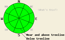
LOW avalanche danger exists at all elevations and on all aspects today. LOW danger does not mean no danger. Even though dangerous avalanche activity should remain unlikely it is not impossible. Continue to use normal caution when traveling in the backcountry. |
|
|
|
The high pressure ridge over the region should allow the calm, clear weather to continue. Like yesterday, air temperatures above 7000 ft should reach into the low to mid 30's today. This ridge should also allow light easterly winds to continue. This morning an inversion exists below 7000 ft with temperatures in the teens and some valley fog. Calm, clear weather should allow these inversions to continue.
On Waterhouse Peak yesterday, cold, soft unconsolidated snow remained on the snow surface on the sheltered E-NE-N-NW aspects. Hand pits, layer bonding tests, and ski cuts on steep test slopes showed stable results in this area. Significant settlement and consolidation continues to occur in the snowpack. On Echo Peak above treeline on open slopes exposed to the east winds, firm, wind-affected snow existed on the snow surface. On some of the lower-elevation, SW-W, sun-exposed aspects, along Hwy 89 some small, inconsequential roller balls did occur near exposed cliffs.
Avalanche Concerns:
Continued settlement and consolidation in the snowpack, mild weather, and light winds will all work together to allow the snowpack to strengthen. Avalanche activity should remain unlikely today. Unlikely does not mean impossible. Some isolated pockets of unstable snow could still lurk on isolated terrain features like very steep couliors or steep unsupported snowfields. Continue to travel with caution and evaluate slopes carefully.
Some roller balls and small wet, loose snow sluffs may continue to occur today due to daytime warming. These should remain very small and not entrain enough snow to snow to bury a person or pose much of a threat to people due to gradual warming, weak early winter sunshine, and short days . They should remain limited to isolated areas on sun-exposed aspects on the southerly half of the compass.
LOW avalanche danger exists at all elevations and on all aspects today. LOW danger does not mean no danger. Even though dangerous avalanche activity should remain unlikely it is not impossible. Continue to use normal caution when traveling in the backcountry.
| 0600 temperature: | 28-32 deg. F. |
| Max. temperature in the last 24 hours: | 32-37 deg. F. |
| Average wind direction during the last 24 hours: | East and Northeast |
| Average wind speed during the last 24 hours: | 0-10 mph |
| Maximum wind gust in the last 24 hours: | 21 mph |
| New snowfall in the last 24 hours: | O inches |
| Total snow depth: | 75-103 inches |
For 7000-8000 ft: |
|||
| Wednesday: | Wednesday Night: | Thursday: | |
| Weather: | Sunny | Clear | Sunny in the morning becoming partly cloudy in the afternoon |
| Temperatures: | 29-36 deg. F. | 13-23 deg. F. | 31-38 deg. F. |
| Wind direction: | Northeast | Variable | Variable |
| Wind speed: | Light | Light | LIght |
| Expected snowfall: | O in. | O in. | O in. |
For 8000-9000 ft: |
|||
| Wednesday: | Wednesday Night: | Thursday: | |
| Weather: | Sunny | Clear | Sunny in the morning becoming partly cloudy in the afternoon |
| Temperatures: | 28-35 deg. F. | 18-26 deg. F. | 30-37 deg. F. |
| Wind direction: | Northeast | East | Southeast shifting to the east during the day |
| Wind speed: | 10-15 mph decreasing in the afternoon | 10-15 mph with gusts to 25 mph after midnight | around 10 mph |
| Expected snowfall: | O in. | O in. | O in. |


This website is owned and maintained by the non-profit arm of the Sierra Avalanche Center. Some of the content is updated by the USDA avalanche forecasters including the forecasts and some observational data. The USDA is not responsible for any advertising, fund-raising events/information, or sponsorship information, or other content not related to the forecasts and the data pertaining to the forecasts.

